_gebco_2022_relief_image_of_the_present-day_australian_continent_showing_the_position_of_.tif)


.tif)


--(c)__representative_outcrops._(a)__type_locality_looking_north_at_8.tif)

--(g)_carbonate_turbidite_facies__(a)_and_(b)_representative_outcrops.tif)
_at_8.7025s__126.7025e__looking_north-wes.tif)
_and_(b)__outcrops_of_mafic_lava_at_8.tif)
.tif)
-(c)__representative_outcrops_of_the_afalari_pelagite._(a)__type_locality_at_8._6138s__.tif)
_and_(b)_note_large_primitive_*lepidocyclina*_(*nep.tif)
.tif)

__low_zone_o7__late_o.tif)
)__upper_m1b_zon.tif)
INTRODUCTION
The island of Timor lies on the northwestern margin of the Australian continent (Fig. 1). It has a complex geological history with a stratigraphic record dating from the latest Pennsylvanian (Late Carboniferous) and encompassing the on-going collision of crustal blocks derived from southern Sundaland (southeastern Asia) with the Australian continental margin. This started during the Late Miocene (Nano et al. 2023; Berry et al. 2024). Because of the dislocated geological structure of the island, considered to be among the most chaotic on Earth by Hamilton (1979), sedimentary formations are difficult to map. The island includes successions of strata deposited under very different marine environments, in some cases on or adjacent to different continents. These successions were juxtaposed during the collision of crustal blocks to form the Timor orogenic belt. Stratigraphic associations, each with a different set of stratigraphic units, are repeated at different localities in this collisional belt. These have different tectonic histories. Four main pre-collision tectonostratigraphic associations are recognized (Haig et al. 2019, Haig et al. 2021a, b, Barros et al. 2022, Nano et al. 2023, McCartain et al. 2024): Late Carboniferous–Middle Jurassic East Gondwana Interior Rift Association (EGIRA); Late Jurassic–mid Late Miocene Timor–Scott Plateau Association (TSPA); Late Jurassic to earliest Miocene Overthrust-Terranes Association (OTA); and late Middle Jurassic to Miocene Overthrust Ocean-Basin Association (OOBA). The “Overthrust-Terranes” were considered by Nano et al. (2023) to be separate blocks and not to belong to a continuous overthrust crustal sheet (e.g., previously designated as the Banda Terrane by Harris et al. 1998). The evidence is low thermal maturity in some areas in EGIRA strata exposed between the overthrust blocks. This indicates that there has been no substantial burial of the EGIRA succession in these areas under an overthrust crustal sheet.
_gebco_2022_relief_image_of_the_present-day_australian_continent_showing_the_position_of_.tif)
Nano et al. (2023) demonstrated the geological complexity in the Matebian Overthrust Terrane, the largest sedimentary OTA block in Timor. Stratigraphic units were shown to have been deposited in very different environments, some on different continents and to have been amalgamated on the southern margin of Sundaland (in the region of south-east Java and southern Sulawesi) before being rifted as a crustal block away from this margin (with the opening of the Banda Sea) and rolled back onto an advancing Australian continental margin (viz. Timor–Scott Plateau) during the Late Miocene. This paper formally describes the stratigraphic units summarily outlined by Nano et al. (2023). Based on the new outcrop mapping of the Matebian Range in Timor-Leste reported in Nano et al. (2023), nine stratigraphic units are described; all newly recognized on the mountain; six units are new. Detailed structural analysis of discordant outcrops on the mountain has still to be completed and because of the highly complex melange-like structure a detailed geological map cannot be given at this time. However, most of the units have been recognized on other overthrust-terrane mountain ranges in Timor-Leste and therefore are more than of local significance. The stratigraphic framework outlined here provides a critical basis for future geological mapping in the country. Each of the new units is recorded by: (i) definition, typical localities, outcrop style; (ii) rock types and distribution on Matebian Range; (iii) age; (iv) distribution elsewhere in region; and (v) depositional environment.
Perdido Limestone
Background and distribution on Matebian Range
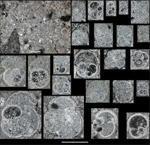
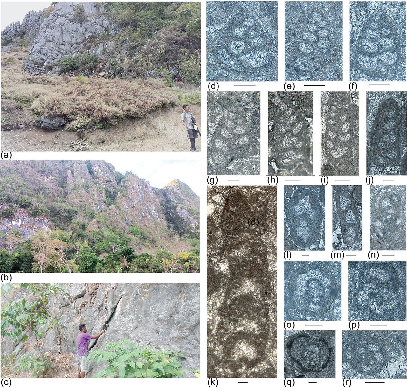
The Perdido Limestone was defined by Benincasa et al. (2012) with a type locality on the southeast slopes of the Mundo Perdido fatu (= limestone peak or ridge) to the west of the Matebian Range. It forms prominent cliff exposures on many of the high ridges of the Matebian Range (Fig. 2a–c; Nano et al. 2023, fig. 2). It is characterized by massive oolitic grainstone, mixed ooid–peloid–intraclast–skeletal packstone, and wackestone with diagnostic biogenic markers including carbonate-cemented agglutinated foraminifers and dasycladacean algae (Haig et al. 2007; Benincasa et al. 2012; Haig et al. 2021b). It is the “Bahaman facies” part of Audley-Charles’s (1968) mixed Cablac Limestone considered by him to be Lower Miocene because of the presence of a Lepidocyclina–Spiroclypeus foraminiferal assemblage (Te Letter Stage) that we now know defines the Upper Oligocene–lowest Miocene Booi Limestone (Haig et al. 2008, Benincasa et al. 2012, and description of unit below).
From dislocated prominent outcrops on the Matebian Range (e.g., Fig. 2a–c) six major microfacies are interpreted (Fig. 3; Table 1) using Dunham’s (1962) carbonate rock classification and the microfacies classification for subdivision of carbonate ramps by Flügel (2004). Because of severe structural disturbance, field relationships between facies cannot be easily demonstrated. However, transition in rock types from very coarse ooid grainstone (microfacies MFPL1) to wackestone with evidence of a very restricted marine biota (microfacies MFPL6) suggests that a coherent facies association was present before deformation, and this is interpreted below.
Age
Carbonate-cemented agglutinated foraminifers provide the means for correlation of the Matebian Range outcrops with other Perdido Limestone exposures elsewhere in Timor-Leste and to the Global Chronostratigraphic Scale. These microfossils are rare but widely distributed in most microfacies in studied outcrops. Species are difficult to identify because for this study they are evident only from randomly oriented thin sections or acetate peels and because many have micritized walls obscuring microstructures (Fig. 2d–r). Species of the Duotaxis–Siphovalvulina plexus are most common. Some of the Siphovalvulina are very elongate and appear to approach Radoicicina ciarapicae but lack well-formed uniserial adult stages. These are accompanied by rarer examples of indeterminate streptospiral to planispiral endothyrid-like to Bosniella-like morphotypes as well as Everticyclammina praevirguliana. The composition of the foraminiferal assemblage is like that illustrated by Haig et al. (2007, 2021b) from the Perdido Limestone elsewhere in Timor-Leste and ascribed to the Sinemurian–Pliensbachian of the Lower Jurassic. The age of the Perdido Limestone in the Matebian Range is confirmed by the rare occurrences of E. praevirguliana (late Sinemurian to Pliensbachian according to Fugagnoli 2000) and by possible R. ciarapicae (Early Jurassic, Hettangian to Sinemurian, and perhaps later according to Gale et al. 2018). An Early Jurassic (Sinemurian–Pliensbachian) age is also indicated by the presence of the dasycladacean alga Palaeodasycladus mediterraneus (Pia 1920; first recorded as Palaeocladus) that had a widespread Tethyan distribution during this time (Rychinlinski et al. 2018). Sections of this species found in microfacies MFPL6 in the Matebian Range (Fig. 3h) correspond to those recorded by Benincasa et al. (2012) from Mundo Perdido to the west of Matebian, and to the type material described and illustrated by Pia (1920, pl. 6, figs. 1–5) from the Lower Jurassic (Middle Liassic) of southern Italy.
Distribution elsewhere in region
The Perdido Limestone is widespread on many, but not all, fatus in Timor-Leste. Haig et al. (2021b) illustrated foraminifera diagnostic of the Sinemurian–Pliensbachian from (i) the type locality on Mundo Perdido, (ii) a locality just south of Mundo Perdido, (iii) limestone present in the gorge between Fatu Calaun and Fatu Fehuc, (iv) a locality on Fatu Fehuc, and (v) at the Audley-Charles’s (1968) type area of the Cablac Limestone on the Cablaci Mountain Range. As explained by Haig et al. (2021b), the Perdido Limestone is unrelated to the Triassic Bandeira Limestone (Haig et al. 2021a), and no carbonate-platform limestone succession is known from the uppermost Triassic (upper Rhaetian) through lowest Jurassic (Hettangian) in Timor-Leste. The Bandeira Limestone is associated with a different set of stratigraphic units (viz., East Gondwana Interior Rift Association, EGIRA, of Haig et al. 2019, 2021a, 2021b, Barros et al. 2022) from those found with the Perdido Limestone. Overlying the Bandeira Limestone in EGIRA with structural conformity is the Wailuli Formation (Barros et al. 2022; McCartain et al. 2024), a mainly calcareous mudstone unit that ranges from the Rhaetian through the Lower Jurassic and is, in part, coeval with the Perdido Limestone. No detrital material derived from the Perdido Limestone has been found in the basinal outer-neritic Wailuli Formation, whereas in basinal Triassic mudstone formations coeval with the Bandeira Limestone debris-slide deposits derived from the shallow-water limestone are present (Haig et al. 2007; McCartain et al. 2024).
Depositional environment
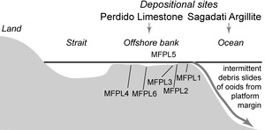
The array of facies in the Perdido Limestone suggests similar diverse environments to those mapped in very shallow water on the Great Bahaman Bank (GBB; Harris et al. 2019, figs. 2, 7). Well-sorted ooid grainstone (MFPL1, Table 1, Fig. 3a) probably formed sand banks in very shallow water in high energy environments near the edge of banks facing an open sea (Fig. 4). Ooids are produced and accumulate as grainstone in GBB in high-energy banks close to the platform margin particularly on its ocean side at water depths of 0–8 m (Harris et al. 2015, 2019). In morphology, the laminated ooids there are very close to those in microfacies MFPL1 of the Perdido Limestone on the Matebian Range (compare Fig. 3a with Harris et al. 2019, figs. 1c, d). On GBB, the ooid banks “shelter” lower energy and slightly deeper-water areas of the platform (mostly < 12 m water depth; Harris et al. 2015). In these areas on GBB, Harris et al. (2015, 2019) mapped grainstone and carbonate mud-poor packstone facies as well as carbonate mud-rich packstone, wackestone and carbonate mudstone. Microfacies MFPL2–5 of the Perdido Limestone on Matebian Range suggests a transition from these high-energy sand accumulations to wackestone with patches of fine peloidal grainstone (MFPL6) indicating a low energy very shallow lagoon in quiet water with probable metahaline salinity (40–55 psu).
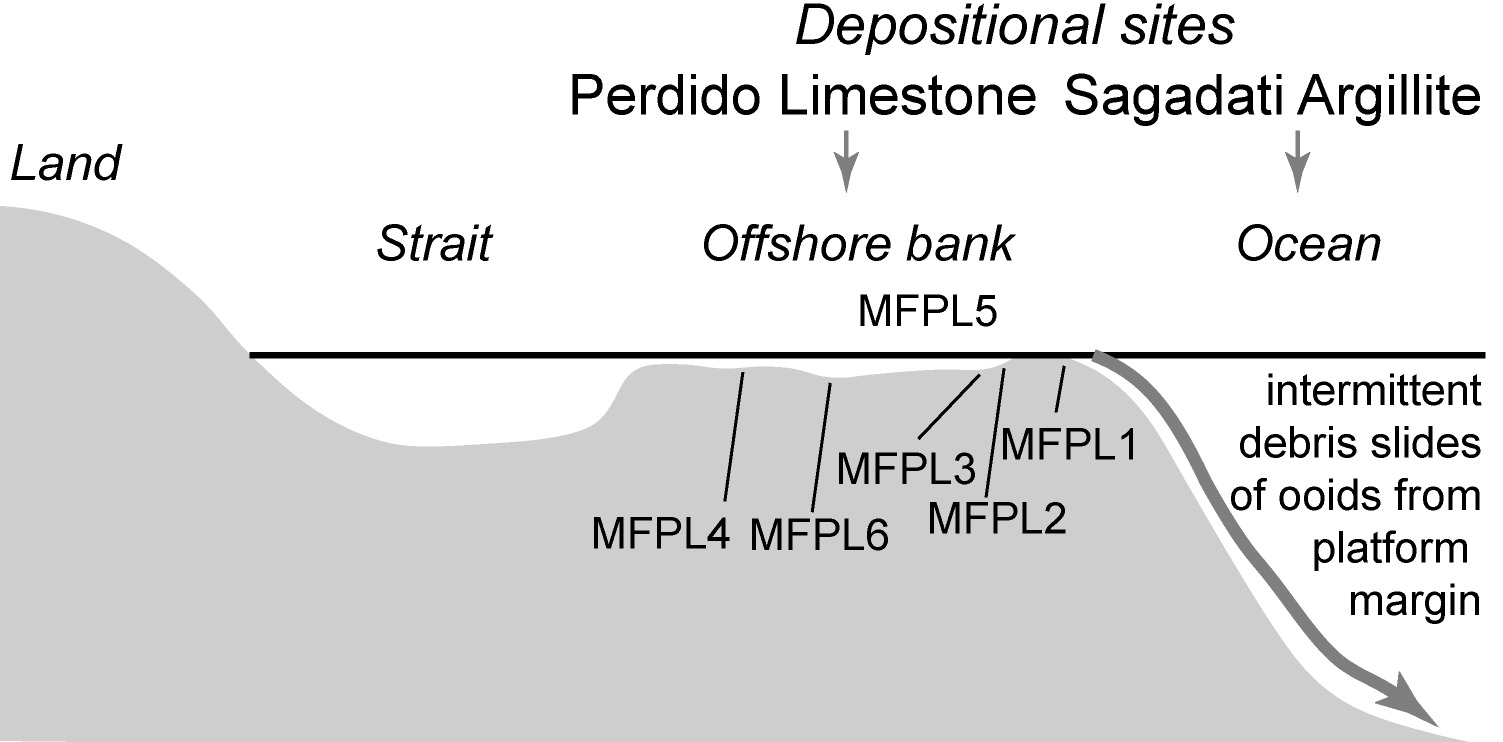
A sparse and poorly diverse biota is present. In the ooid sand, carbonate-cemented agglutinated foraminifers (Fig. 2d–r) and rare microgastropods are the main biogenic grain types with many incorporated in the cores of ooids. In the transitional microfacies (MFPL2–5), these are accompanied by sparse echinoderm plates, and ostracods. In the quiet very shallow lagoon facies (MFPL6, Table 1, Figs. 3h–i), dasycladacean algae are the most common biogenic component of the sediment, with thaumatoporellids rare, carbonate-cemented agglutinated foraminifers rare, and ostracods very rare. The composition of GBB sediment outlined by Newell et al. (1959) corresponds in general details to that found in facies of the Perdido Limestone with ooids, peloids, foraminifera, molluscs, echinoderms, and green algae as major contributors. Green algae are prominent in the low diversity biota found in the mud facies of the high salinity interior “shelf lagoon” (Newell et al. 1959, p. 222–224). The absence of a siliciclastic component in any facies suggests that the Perdido Limestone may have formed in an offshore area (Fig. 4), as in GBB, separated from the mainland by a strait, and away from the influence of terrestrial sediment input.
Sagadati Argillite (new unit)
Definition, type locality, outcrop style
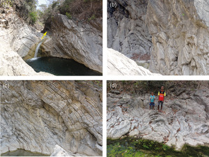
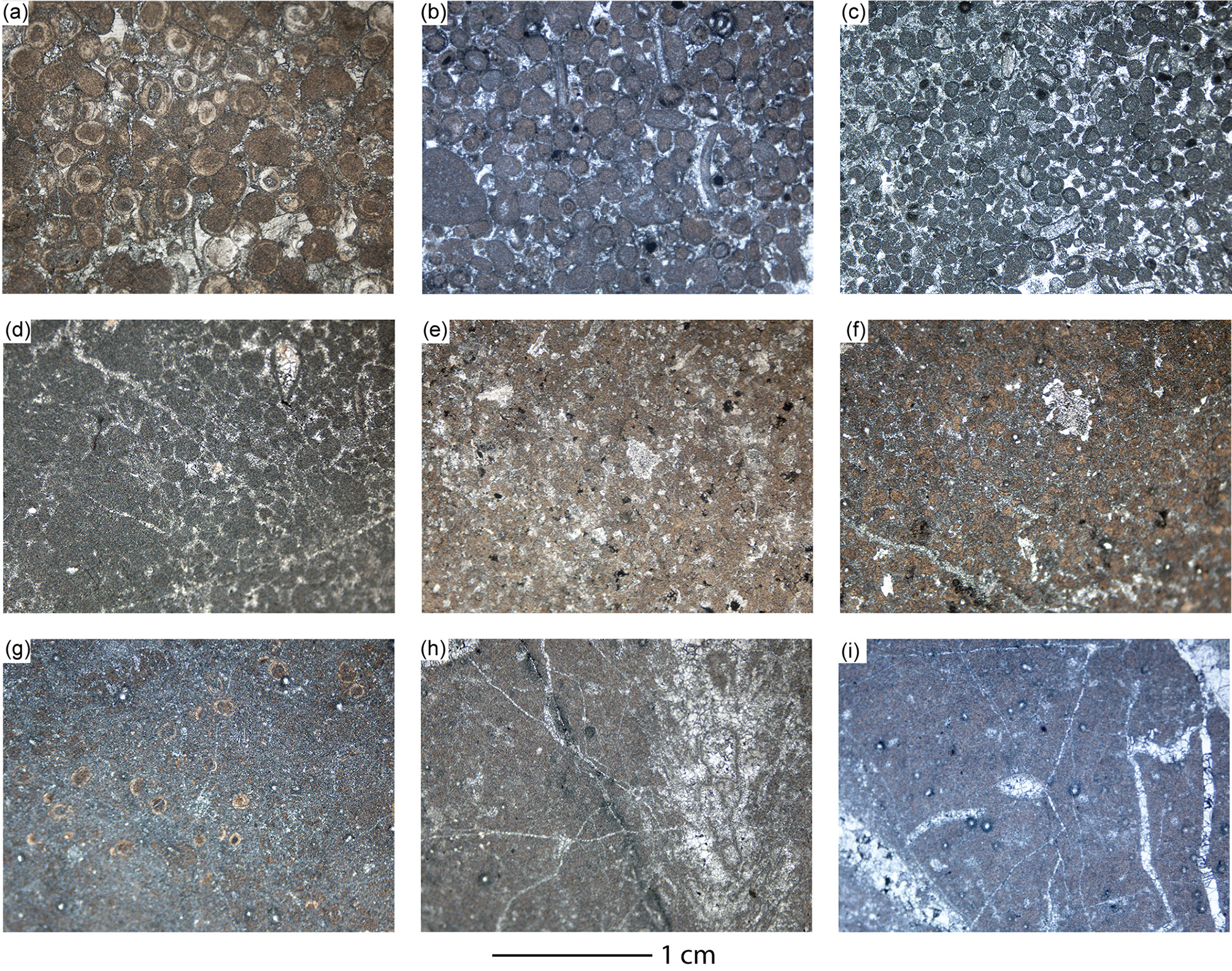
The Sagadati Argillite is dominated by siliceous argillite, with variable carbonate content, intercalated with thin-bedded mudstone. It crops out on the north-eastern side of the Matebian Range (Nano et al. 2023, fig. 2b) where a type section is selected in outcrop on the Tarmaliu River near the waterfall at 8.536191°S, 126.711789°E (Figs. 1c, 5, 6; Nano et al. 2023, fig. 3a, b). The unit is named after the nearby village of Sagadati. Because the Sagadati Argillite is highly deformed with complex folding and faulting (Fig. 7), a measured typical section was made through a package of coherent strata that were considered characteristic of the formation (Fig. 6; Nano et al. 2023, fig. 3). The measured type section is 6 m thick (Fig. 6). Indurated argillite, mainly siliceous but with variable carbonate content, is the dominant rock type. Recrystallized radiolarians are common to abundant (Figs. 8e–g; Nano et al. 2023, fig. 3d). Beds are thin to medium in thickness, and planar with sharp contacts. Indurated argillite beds alternate with very thin beds of dark grey-black friable shale, which in places contain some very small black-red chert nodules. In some argillite beds, small-scale bioturbation is represented by Chondrites-like burrow systems infilled by dark mud (Fig. 8f). Shallow channel cuts are present in the upper parts of some argillite beds (Figs. 6, 8a, d; Nano et al. 2023, fig. 3b, c). These are up to about 4 m wide along strike, have a maximum depth of 25 cm, and seem to have an irregular (erosional) base. Because of lack of suitable outcrop, it is not possible to trace the channels for any distance. Ooid grainstone infills the channels (Figs. 6, 8 a–d). Ooids vary in shape from spherical to ovoid; with some rare, more irregular grains present. Most of the grains have dark micritized interiors with faint concentric layering. Almost all grains have at least one very thin clear layer enveloping their exterior. Rare biogenic grains are also coated by outer concentric layers. These include small gastropods (Fig. 6), echinoid spine fragments, and foraminifers (Fig. 6; Nano et al. 2023, fig. 3e–j). Between the ooids is carbonate spar. In the cement are aggregations of small crystals that appear dark in the acetate peels and may be dolomite replacing, for example, calcite spar.
.tif)

The ooid-rich channel infills are graded and whilst grain-size is difficult to measure from two-dimensional peel images, the largest ooids are up to 750 μm in maximum diameter. In some of the ooid channel fills, ooids have selectively been diagenetically replaced, probably by dolomite or silica, appearing black in the acetate peels (Figs. 8a, d).
Outcrops of the Sagadati Argillite around the type section in Tarmaliu River, have undergone multistage deformation with folding, thrusting and normal faulting (Fig. 7). Therefore, it is not possible to determine the thickness of the unit nor the relationships to underlying or overlying stratigraphic units. The ooids and the contained foraminifers indicate a relationship to the Perdido Limestone (see below).
Distribution on Matebian Range
The northern area of the Matebian Range consists of rolling hills that have outcrop similar to that in the type area of the Sagadati Argillite. Similar ooid-filled channel-cuts in a radiolarian-rich siliceous argillite succession have been observed near Atelari Village (Fig. 5). Further south in the range, there are massive outcrops of ooid grainstones belonging to the coeval Perdido Limestone.
Age
The cores within ooids in the channel-fill grainstone are, in rare examples, formed by single foraminiferal tests (e.g., Fig. 6; Nano et al. 2023, fig. 3e, f, h). Other foraminifers are present free from ooid development. All are considered almost contemporaneous to deposition of the grainstone and the siliceous argillite beds because: (i) the ooids and isolated foraminifers are present as isolated grains not parts of lithoclasts; and (ii) the foraminifers that are enveloped by very thin layers of clear carbonate with radial fibrous microstructure show little sign of corrosion, abrasion, or encrustation by later cement; and (iii) free foraminifers show few signs of any abrasion and are cement infilled. The foraminifers are carbonate-cemented agglutinated types. Many are in orientations in the acetate peels that make specific identifications impossible, and their walls have been heavily micritized. The most common morphotypes that can be identified belong to forms (e.g., Nano et al. 2023, fig. 3g–j) of the Bosniella–Mesoendothyra complex (Haig et al. 2021b) with species indeterminant because the wall microstructure (e.g., presence of parapores) is uncertain. Similar types are very common in ooid limestones of the Perdido Group in the Samora River and at Mount Fehuc (area J2, Haig et al. 2021b). Following arguments advanced by Haig et al. (2021b), the age is Early Jurassic. Also present in the Sagadati channel-fills are tests belonging to Siphovalvulina (Nano et al. 2023, fig. 3e, f) like those recognized in the Lower Jurassic Perdido Group ooid limestones (Haig et al. 2021b). Very rare examples are present that seem to be tests of the Early Jurassic (Sinemurian–Pliensbachian) Everticyclammina praevirguliana (Fig. 6) that occurs in the nearby Perdido Limestone (see Fig. 2). The shallow-water Bahaman facies of the Perdido Limestone (Haig et al. 2007; 2021b) and the sections of Sagadati Argillite with channels infilled by ooids are considered contemporaneous and Early Jurassic.


Distribution elsewhere in region
The bioturbated wackestone (UWA144817) from Mundo Perdido (See Nano et al. 2023, fig. 1c) that Benincasa et al. (2012, appendix 2, table A1, p. 20) attributed to the Aitutu Formation probably belongs within the Sagadati Argillite. The wackestone had “abundant recrystallised radiolaria, common sponge spicules, rare ostracod valves, and very rare carbonate-cemented agglutinated foraminifera”. They noted that “patches of peloidal grainstone lacking radiolaria” were present. The foraminifer recorded was Siphovalvulina associated with the grainstone. It is now known that Siphovalvulina is not present in the Timor Triassic but is common in the Lower Jurassic here (Haig et al. 2021a, 2021b).
Depositional environment and significance of ooid-infilled channel cuts
The thin to medium planar bedding, the abundance of radiolarians, the sparseness of benthic fauna except for rare ostracods, sponge spicules and minute nodosarian foraminifers suggest that the depositional site was open marine and deposited in the lower bathyal zone above the calcite compensation depth. The deep-water radiolarian-rich Sagadati Argillite is “stitched” to the shallow-water Perdido Limestone by ooid-filled channel cuts in the argillite. The dimensions of the channel cuts indicate that these were distal from the high-energy platform margin where the ooids were generated (Fig. 4).
The depositional site of the Lower Jurassic Perdido-Sagadati association was probably on an open continental margin, as distinct from in the East Gondwana Interior Rift where the coeval Wailuli Formation was deposited (Haig et al. 2021a, b). Note that, unlike older basinal units in EGIRA, no debris-slide deposits with clasts derived from a contemporaneous (or indeed older) carbonate platform have been observed in the Wailuli Formation. The adjacent shelf during Wailuli Formation deposition was accumulating siliciclastic units such as the Malita and Plover formations (Mory 1991). Although the Sagadati Argillite is not related to the Waliluli Formation, it may be an Early Jurassic precursor to the deep-ocean late Middle Jurassic (Bathonian–Callovian) siliceous argillite–radiolarian chert unit from near Viqueque that was assigned to the “Noni Group” by Haig and Bandini (2013). Despite the suggestion of Munasri and Harsolumakso (2020), the latter unit should not be included in the Rhaetian to Early Jurassic Wailuli Formation which is characterised by very different facies dominated by heavily bioturbated calcareous mudstone deposited in a shallow continental rift basin.
Tibalari Pelagite (new unit)
Type locality, outcrop style
The type locality is on the slope of Matebian Feto (the female limestone peak) at 8.6427°S, 126.5937°E (Figs. 1c, 9). Here the Tibalari Pelagite consists of pale grey limestone with karstic weathering (Fig. 10). The limestone contains sparsely scattered irregular chert inclusions, most ranging in size up to about 20 cm in length. Bedding is obscure and the limestone appears massive although cut by steeply dipping fractures at the type locality. The type outcrop extends laterally for about 200 m. Higher on the ridge above an area covered by soil, similar Tibalari Pelagite is present at the crest of the mountain (see the olistolith locality described below, just under the Statue of Christ on the summit of Matebian Feto). Nearby outcrops include the Lower Jurassic Perdido Limestone, the Upper Oligocene to lowest Miocene Booi Limestone and Atelari Mudstone, and a volcanic unit that is probably the Middle Eocene Barique Volcanics. Much of the type area south of the crest of Matebian Feto is under soil and vegetation cover. Contacts of the type Tibalari Pelagite with adjacent units are obscure but must be faults. To the northeast of the crest of Matebian Feto on an inaccessible slope, possible Tibalari Pelagite show either thick steeply dipping bedding or a steeply dipping regular fracture system (Fig. 9).
Rock types and distribution on Matebian Range
Limestone forming the Tibalari Pelagite is a wackestone with scattered rare planktonic foraminifers in a carbonate-mud matrix. Many of the foraminiferal tests show evidence of some dissolution and breakage. At one locality (at 8.6883°S, 126.6556°E), inoceramid shell fragments and individual calcite prisms from disaggregated shells are present in the carbonate mud matrix. Planktonic tests are infilled with calcite mosaic cement, or partly infilled with micrite. No benthic foraminifers have been observed in acetate peels of the beds.

--(c)__representative_outcrops._(a)__type_locality_looking_north_at_8.tif)
In many places, the rock is cut by microfractures infilled with calcite mosaic cement and by iron enriched stylolites. Associated with the Tibalari Pelagite along the crest of Matebian Feto are two very large blocks of Perdido Limestone (Nano et al. 2023, fig. 4). The limestone forming the blocks is a well-sorted ooidal–peloidal grainstone–packstone (Nano et al. 2023, fig. 4d). The ooids have many concentric laminae around micritic cores; some ooids are micritized. Biogenic grains include very rare echinoid plates (including spines) and poorly preserved carbonate-cemented agglutinated foraminifera; very rare bryozoans; very rare fragments of bivalves; very rare gastropods; rare algae fragments; and very rare nodosarian foraminifers. Grain size is lower coarse sand class. In patches a granular mosaic cement is present. Contacts with the planktonic foraminiferal wackestone of the Tibalari Pelagite are not structural (Nano et al. 2023, fig. 4c) and one of the Perdido blocks clearly shows intensive fracturing that does not affect the adjacent Tibalari Pelagite (Nano et al. 2023, fig. 4b). In the Tibalari Pelagite immediately adjacent the contact, planktonic foraminifers are crushed (Nano et al. 2023, fig. 4e). The Perdido Limestone blocks are interpreted as olistoliths that slid downslope to become embedded in the deep-sea carbonate ooze that formed the Tibalari Pelagite.
On the Matebian Range, the Tibalari Pelagite is known only from the southern sector of the range. Apart from the localities discussed above, pale grey to pale red pelagite with karstic weathering is well exposed in the Namanei area on the north side of Matebian Mane and in the Afalari area at the south-east side of Matebian Mane (Figs. 10b, c).
Age
Planktonic foraminifers are difficult to identify with precision in random sections. Age-diagnostic planktonic species include probable Praeglobotruncana delrioensis (Fig. 10d), Thalmanninella of the T. globotruncanoides (Sigal)–T. brotzeni Sigal–T. gandolfi (Luterbacher and Premoli Silva) group (Fig. 10e–g) and Rotalipora cushmani (Fig. 10h), characteristic of the Cenomanian (pforams@mikrotax.org; 100.5–93.9 Ma, International Commission on Stratigraphy Chart v.2022, v.10). Many samples contain Helvetoglobotruncana helvetica (Fig. 10i–l), Dicarinella spp. (Fig. 10m–q), Marginotruncana pseudolinneiana (Fig. 10r, s), and Planoheterhelix globulosa (Fig. 10t, u), collectively indicative of the overlying Turonian (pforams@mikrotax.org; 93.9–89.8±0.3Ma, International Commission on Stratigraphy Chart v.2022, v.10). Samples with Helvetoglobotruncana belong within the time range of 93.5 Ma – 92.6 Ma.
Distribution elsewhere in region
Elsewhere in Timor-Leste, the Tibalari Pelagite is present on Mundo Perdido where it was placed by Benincasa et al. (2012) in the “Kolbano Beds” (see their appendix 2, table A1, samples UWA143149, 143169, 144716, 144718, 144726, 144757). The Tibalari Pelagite differs from the Borolalo Formation of the Timor Scott Plateau Association (see Haig et al. 2019) by a mainly Cenomanian–Turonian stratigraphic range in contrast to the mainly Campanian–Maastrichtian range of the latter formation. Chert nodules present in the Tibalari Pelagite have not been recorded from the Borolalo Formation. The Tibalari Pelagite and the Borolalo Formation in Timor-Leste are associated in the field with different sets of stratigraphic units. The stratigraphic makeup of the Kolbano succession in West Timor, including the “Ofuserie” of Wanner (1913) and later modifications (De Waard 1955; Barber et al. 1977; Rosidi et al. 1979; Charlton and Suharsono 1990; Sawyer et al. 1993; Charlton and Wall 1994; Harsolumakso et al. 2019) requires major documentation and revision of the planktonic foraminifera and any other index microfossils, microfacies and rock-unit associations before reasonable correlations to pelagite successions in Timor-Leste can be made. A revision is needed of the Wai Bua beds (Audley-Charles 1968) in Timor-Leste, based on the type area near Betano where late Aptian-early Albian planktonic foraminifers are present (Haig and McCartain 2007).
Depositional environment
As suggested by the low abundance of planktonic foraminifers many of which show evidence of selective dissolution and the sparsity of benthic foraminifers and other fossils, the Tibalari Pelagite was probably deposited close to the Calcite Compensation Depth (depth in the ocean at which calcite dissolves, probably around 3500–4000 m during the Cretaceous; Van Andel 1975). In contrast to the deep-sea depositional environment of the Cenomanian–Turonian wackestone, the ooidal–peloidal grainstone–packstone forming the olistoliths (derived from the Perdido Limestone) was deposited in a sand bank under very shallow-water high-energy conditions (see section on Perdido Limestone). The olistoliths probably were eroded during the Turonian from outcrops of Lower Jurassic Perdido Limestone at a continental edge fronted by oceanic sediment. The Perdido Limestone blocks slid downslope to become embedded in the deep-sea carbonate ooze that became the Tibalari Pelagite. The ocean must have been close to a continental margin where severe deformation of strata no older than late Early Jurassic and no younger than Early Cretaceous had taken place.
Lakamutu MUDSTONE (new unit)
Definition, typical localities, outcrop style
Red mudstone dominates the Lakamutu Mustone but the mudstone crops out poorly in areas of subdued topography with soil and vegetation cover (e.g., Fig. 11). Along the Lakamutu River thick to thin-bedded red to light grey calcareous sandstone, calcilutite, red siliceous argillite, thin black shale and less common medium-bedded brown chert are exposed within the mudstone succession. Three of these sections are chosen to typify the facies: at (i) 8.6404°S, 126.6742°E, (ii) 8.6391°S, 126.6734°E, and (iii) 8.6352°S, 126.6722°E (Fig. 11). The indurated beds are either isolated in the mudstone (as in type locality i, Nano et al. 2023, fig. 5a) or form a closely interbedded succession of limestone and friable, sometimes laminated, mudstone (as in type locality ii, Nano et al. 2023, fig. 5c). Most are less than 0.5 m thick, with rare examples exceeding 1 m. The beds have planar surfaces.
Rock types and distribution on Matebian Range
Within the red mudstone, the limestone interbeds are coarse to fine calcarenite with some beds showing both planar laminations and small-scale cross-laminations (Fig. 12a, b). Other limestone beds are “chalky”. The calcarenite is mainly shades of pale red, but some beds are pale grey and pale blue green. The sand component in the calcarenite is usually tightly packed and in some is composed almost entirely of planktonic foraminifers; in other beds these are mixed with micritic clasts, quartz, and ooid limestone clasts. Most of the planktonic foraminifers are well preserved and infilled by mosaic calcite cement. Very rare tests of larger benthic foraminifers are present (Nano et al. 2023, fig. 5f–h). At 8.63614°S, 126.67201°E, thin bedded planktonic foraminiferal calcarenite beds, with sole-mark groves at base, grade to white mudstone. Less common beds of quartz sandstone also occur. Thin sections (including Nano et al. 2023, fig. 5d) demonstrate that the quartz-feldspar sandstone contains quartz (both clear and polycrystalline types), feldspar (plagioclase and microcline), muscovite, pyroxene, glauconite, unidentified opaque minerals, and carbonate clasts (including foraminifers). Grains are cemented by calcite. Most of the feldspar grains are partly replaced by calcite. The siliciclastic component suggests a volcanic plus a metamorphic source. At one site, the Lakamutu Mudstone are closely associated with volcaniclastic deposits which we place in the Barique Volcanics (see below).

--(g)_carbonate_turbidite_facies__(a)_and_(b)_representative_outcrops.tif)
Red friable mudstone associated with the limestone contains small poorly preserved planktonic and benthic foraminifers. Areas of red friable mudstone are present on the high mountain slopes of the southern Matebian Range; most of the samples taken from these areas have been barren of microfossils.
The stratigraphic base and top of the Lakamutu Mudstone have not been recognized, and relationships to adjoining units seem to be faulted. Because of similarities in grain composition and possibly age, the Liloli Calcarenite (see below) that is composed of more massive limestone may be a related unit more proximal to the source of the carbonate clasts than was the Lakamutu Mudstone. A “basal conglomerate”, illustrated by Harris (2006, p. 220), apparently from the “base of Mata Bia” contains Nummulites and discocyclinid larger benthic foraminiferal fragments as well as rare small indeterminant planktonic foraminifera. The locality and immediate field relationships of this conglomerate were not detailed. It may belong as a debris slide within the Lakamutu Mudstone or the related Liloli Calcarenite. The larger benthic foraminifers are of Middle Eocene age and are accompanied by volcanic and metamorphic clasts (Harris, 2006, fig. 6).
Age
Planktonic foraminifers from a red mudstone in the Lakamutu River at 8.6361°S, 126.6720°E include Acarinina boudreauxi Fleisher, Acarinina bullbrooki (Bolli), Acarinina praetopilensis (Blow), Globigerinatheka curryi Proto-Decima and Bolli and Morozovelloides coronatus (Blow). These collectively suggest an age of 45–43 Ma in the Middle Eocene (pforams@mikrotax.org). Preservation of the planktonic foraminifers in the calcarenite beds, although transported downslope, suggest that these are probably contemporaneous with the red mud deposition. They include Acarinina spp. including A. bullbrooki, A. praetopilensis (Fig. 12d, e), Hantkenina sp. (Fig. 12g) and Subbotina senni (Beckmann) (Fig. 12c). Collectively these are indicative of a Middle Eocene (Lutetian) age (pforams@mikrotax.org).
The rare larger benthic foraminifers present in some samples, including Alveolina sp. (Nano et al. 2023, fig. 5f), Discocyclina sp. (Nano et al. fig. 5g) and Asterocyclina sp. (Nano et al. 2023, fig. 5h), also indicate a Middle Eocene age. Haig et al. (2019) illustrated a coeval foraminiferal assemblage from a neritic limestone at the type locality of Audley-Charles’s (1968) “Barique Formation”.
Distribution elsewhere in region
On Mundo Perdido to the west of the Matebian Range, Benincasa et al. (2012) recorded Middle Eocene packstone (UWA144757, 144776) and red mudstone (UWA 144775, 144854) with similar planktonic foraminifers to those in the Lakamutu Mudstone. They attributed the Mundo Perdido beds tentatively to the “Barique Formation”. Similarities in rock types and diagnostic foraminifers indicate that these occurrences should be referred to the Lakamutu Mudstone.
Depositional environment
Rock types found in the Lakamutu Mudstone correspond to those encountered in the Cretaceous and Cenozoic section cored in Ocean Drilling Program (ODP) Hole 765. This ODP Site is in the Argo Abyssal Plain, drilled at 5721 m water depth, to the south of Timor about 50 km outboard of the junction between the Scott and Exmouth plateaus (subsided marginal plateaus of the Australian continent). Here, mudstone (usually red) dominates in the Upper Cretaceous and Paleogene and contains interbedded turbiditic “calcareous sediments”, turbiditic “nannofossil chalk” and matrix-supported conglomerates interpreted as debris flows (Shipboard Scientific Party, 1990). It is probable that the Lakamutu Mudstone had a similar abyssal depositional environment to the coeval deposits in the Argo Abyssal Plain, although probably not in the vicinity of this plain. The concentrations of well-preserved planktonic foraminifera in some calcarenite beds contemporaneous with those found in the red mudstone indicates that pelagic sediment was present upslope from the depositional site. The chalky limestone may represent the winnowed out nannofossil-mud component (of the source pelagite) that settled after turbiditic calcarenite deposition. The presence of Middle Eocene larger benthic foraminifera indicates a nearby shelf accumulating carbonate-platform sediment, and this suggests that land may have been present in the vicinity. On the upper slope or on adjacent land, exposures of oolitic limestone (probably the Perdido Limestone) were present and contributed clasts to the calcarenites. In the hinterland, volcanic and metamorphic rocks contributed to the quartz-feldspar sandstone beds and to the conglomerate reported by Harris (2006).
Liloli Calcarenite (new unit)
Definition, type locality, outcrop style
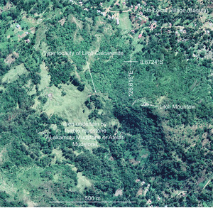
Successions (greater than 20 m thick) of thick crudely bedded calcarenite make up the Liloli Calcarenite (Fig. 13a, b; Nano et al. 2023, figs. 6a). The type locality is at 8.6740°S, 126.6139°E (Figs. 1c, 14). The type outcrop extends laterally for about 500 m. As indicated above, this unit may be related to the Lakamutu Mudstone, but its overall thickness and bedding style places it as a separate mappable entity. Relationships to the underlying and overlying units are not known; contacts are covered by soil and scree.
_at_8.7025s__126.7025e__looking_north-wes.tif)

Rock types and distribution on Matebian Range
The calcarenite is well sorted with sparry calcite cement. Grain types are dominated by micritized clasts some of which contain ooids (Nano et al. 2023, fig. 6c). Rare large clasts with probable thaumatoporellid algae in a micritic matrix are present (Nano et al. 2023, fig. 6b). Other micritic clasts contain planktonic foraminifers including very rare globotruncanids (including possible Dicarinella and Marginotruncana; Nano et al. 2023, fig. 6d) of the Upper Cretaceous (possibly Turonian) and more common but scattered Subbotina, Acarinina and Morozovelloides of the Middle Eocene (Nano et al. 2023, fig. 6e). Some of the latter appear free of matrix. A feature of the rock is the common occurrence of scattered dolomite rhombs.
On Matebian range, the Liloli Calcarenite is distributed mainly along the south-east side of the range and on the west side of Matebian Mane (male Matebian peak that is close to Matebian Feto). The calcarenite has also been found on Bina Range on the southern boundary of the Matebian Terrane. Elsewhere in Timor-Leste, the Liloli Calcarenite has not been reported
Age
The youngest microfossils observed in the Liloli Calcarenite are free of matrix and belong to small indeterminant Acarinina and the Morozovella caucasica–aragonensis group of the upper Lower to lower Middle Eocene (pforams@mikrotax. org). This suggests that the Liloli Calcarenite is approximately the same age as the Lakamutu Mudstone.
Depositional environment
The Liloli Calcarenite was deposited as a debris slide mainly composed of clasts derived from rock units exposed higher on a submarine slope or in adjacent land areas. The rock units included the Lower Jurassic Perdido Limestone as well as the Upper Cretaceous Tibalari Pelagite. The water depth was probably shallower than the depositional site of the Lakamutu Mudstone and was more proximal to the provenance areas of the clasts.
BARIQUE VOLCANICS
Background and distribution on Matebian Range
This mainly volcanic unit was originally named by Audley-Charles (1968) the “Barique Formation” and a type locality selected by him along the Quique River to the west of the Matebian Range. Haig et al. (2019) re-examined outcrop at the type locality and found mainly dark green-grey tuffs, blue-grey mudstone, some mafic lava, and isolated occurrences of shallow-marine Middle Eocene limestone. Some beds of the limestone contain volcaniclastic clasts and were included in the Barique Formation (now referred to as the Barique Volcanics).
In the Matebian Range a similar association of mafic volcanics with green-grey tuffaceous sandstone, laminated fine sandstone and mudstone crop out in the Samalari River (Fig. 15). A laminated (? tuffaceous) sandstone at 8.6029°S, 126.6673°E (Fig. 15d) contains poorly preserved Middle Eocene planktonic foraminifers like those found in the Lakamutu Mudstone. The volcanics at 8.6062°S, 126.6670°E inter-tongue with similar sediment (Fig. 15b), and display surfaces with ropey-lava texture (Fig. 15c). Until detailed study is made of the volcanic rocks, these are tentatively referred to the Middle Eocene Barique Volcanics. At the type locality as well as in the Matebian Range, stratigraphic relationships are uncertain.
_and_(b)__outcrops_of_mafic_lava_at_8.tif)
AFALARI PELAGITE (NEW UNIT)
Definition, type locality, outcrop style
The Afalari Pelagite consists of indurated wackestone with scattered planktonic foraminifers and, in some beds, radiolaria. The rock is massive and pale red or pale grey on fresh surfaces. It usually forms limestone cliff outcrops. The planktonic foraminifera have well-preserved test microstructure but small tests show breakage and corrosion indicative of partial dissolution. Benthic foraminifers are extremely rare. No mass-flow deposits have been found associated with the unit. The type locality is at 8.6138° S and 126.6400° E (Fig. 16). The type outcrop is observed in a valley at the termination of the main road in Afalari town. This unit also can be observed in the foothill ridge to the east of Matebian Mane. On the south of the type locality, outcrops of the Oligocene Booi Limestone and Lower Jurassic Perdido Limestone are present. Contacts between the Afalari Pelagite and adjacent units are covered but are considered faults.
Age
Planktonic foraminifera include Dentoglobigerina tripartita (Koch) (Fig. 17d–g); Dentoglobigerina globularis (Bermúdez) (Fig. 17h); Dentoglobigerina sp. cf. D. sellii (Borsetti) (Fig. 17i); Ciperoella ciperoensis (Bolli) (Fig. 17j–l) and Ciperoella sp. (Fig. 17m). The age is Middle Oligocene, late Rupelian (ca. 30 Ma to 28 Ma; pforams@mikrotax.org) because of the absence of Dentoglobigerina binaiensis, a species common in the Upper Oligocene Atelari Mudstone in the Matebian region (see below).
.tif)
-(c)__representative_outcrops_of_the_afalari_pelagite._(a)__type_locality_at_8._6138s__.tif)
Distribution elsewhere in region
Similar limestone is widespread on Mundo Perdido, a major fatu west of the Matebian Range, where Benincasa et al. (2012) recorded it as part of the “Kolbano Beds”. Here it is also massive and forms limestone cliffs, and the planktonic foraminifera are scattered in the micritic matrix and in some beds show breakage due to dissolution as in the Afalari Pelagite.
Depositional environment
The scattered occurrence of planktonic foraminifera, the appearance of well-preserved radiolarians associated with less common planktonic foraminifera in some beds, the common breakage/dissolution of small planktonic foraminiferal tests, and the sparsity of benthic foraminifera indicate that the Afalari Pelagite was deposited in the lower bathyal zone approaching the lysocline and Calcite Compensation Depth (as deep as 4400 m during the Oligocene in the Indian Ocean according to Van Andel 1975). During the middle Oligocene no mass-flows of detrital material from an upslope area interrupted the pelagite deposition.
BOOI LIMESTONE
Background and distribution on Matebian Range
The Booi Limestone was named by Haig et al. (2008) for the upper Oligocene-lowest Miocene part of Audley-Charles’s (1968) Cablac Limestone with type locality in the Noni and Niti river valleys in West Timor. The limestone is of carbonate-platform facies (Fig. 18) characterized by larger benthic foraminifers including Lepidocyclina (Eulepidina and primitive Nephrolepidina) and Spiroclypeus characteristic of the Upper Oligocene to lowest Miocene (Aquitanian) age (Haig et al. 2019). The Booi Limestone, deposited on a narrow shelf, has widespread isolated occurrences in the study region and on other Timor fatus associated with the same stratigraphic units as on Matebian Range.
_and_(b)_note_large_primitive_*lepidocyclina*_(*nep.tif)
On Matebian Range, an easily accessible typical outcrop of the Booi Limestone occurs at 8.5799°S, 126.6754°E. Here foraminiferal-algal-coral wackestone/ floatstone (Nano et al. 2023, fig. 7a, b) forms the main outcrop which is associated with medium to thin beds of conglomerate (Nano et al. 2023, fig. 7c, d) immediately to the south. The conglomerate has many clast types including (i) Oligocene planktonic foraminiferal pelagite derived from Afalari Pelagite ; (ii) Late Cretaceous (Turonian) planktonic foraminiferal pelagite derived from Tibalari Pelagite; (iii) radiolarian-rich argillite derived from Sagadati Argillite; (iv) ooid and peloidal grainstone and packstone derived from the Perdido Limestone; (v) igneous/volcanic mafic clasts probably from the Barique Volcanics; (vi) sandstone and possible chert, with the chert similar to that found in the Tibalari Pelagite.
ATELARI MUDSTONE (NEW UNIT)
Type section
The Atelari Mudstone is the youngest and least deformed unit on Matebian Range. The best exposed section of the Atelari Mudstone is in the Atelari River on the east side of the Range (Fig. 19). The type section is continuous along the river between 8.5617°S, 126.6890°E and 8.5625°S, 126.6899°E where it is terminated by a fault (Fig. 20). The base of the formation is taken at the top of the highest limestone bed (Nano et al. 2023, fig. 8a), with planktonic foraminifers of Late Oligocene age (Fig. 21), in the conformably underlying unit (un-named at this stage because it could not be examined here as the section is within a sacred site not accessible for our studies). Mudstone with interbedded sandstone crops out in discontinuous river-cliffs downstream between 8.5625°S, 126.6913°E and 8.5616°S, 126.6923°E, but the age of these exposures has not been determined, although they are suspected to be part of the Atelari Mudstone. At 8.5604°S, 126.6930°E thin bedded bioturbated muddy limestone of the Aitutu Formation (Upper Triassic) crops out and it is assumed that there is a major fault separating the Aitutu Formation from the mudstone unit. The type section of the Atelari Mudstone is 68 m thick (Fig. 20) and includes five units that gently dip to the east.
.tif)


Unit 1 is 21 m thick and includes the lower part of the formation (Fig. 20). It is composed mainly of massive calcareous mudstone, blue-grey when fresh, pale grey when weathered (Nano et al. 2023, fig. 8b). The base of the Atelari Mudstone is conformable on a pale grey limestone bed (Nano et al. 2023, fig. 8a). At about 40 cm above base, a 15 cm-thick conglomerate composed mainly of limestone clasts is present (Nano et al. 2023, fig. 8a). The ages of various clast types and their provenance are discussed below and are crucial for understanding the tectonostratigraphic history of the mountain range. The calcareous mudstone at 5m above base contains a diverse assemblage of planktonic and benthic foraminifers (Figs. 22a, b; see discussion below for interpretations of age and bathymetry). Planktonic foraminifers dominate the assemblage. The benthic foraminifers include diverse types. These are the only fossils found in the unit.
Unit 2 is much less calcareous than Unit 1, although the transition seems gradual. It is about 13 m thick (Fig. 20), and composed of massive, grey to dark grey mudstone that at several levels includes dark more-coherent mudstone pebbles to several centimetres in diameter. A foraminiferal assemblage, which is much less abundant and less diverse than that from Unit 1, has been recovered from about 22 m above base of formation. Planktonic foraminifers (Fig. 23) completely dominate the assemblage, with very few benthic types recovered. Palynomorphs were also recovered from this level but are mainly reworked Cretaceous types (see discussion on sediment provenance, below).
__low_zone_o7__late_o.tif)
)__upper_m1b_zon.tif)
Unit 3 contains the first major influx of sand and is 5.5 m thick (Fig. 20). The unit grades from a greenish-grey sandy mudstone to a muddy lithic sandstone. No bedding is apparent, and no fossils have been observed.
Unit 4 includes 23.5 m of massive dark grey to grey mudstone. No fossils have been observed. Unit 5 has at its base a 30 cm thick bedded laminated fine lithic sandstone, cross-laminated in part. It is overlain by massive green-grey mudstone. At about 68 m above the base of formation a major fault truncates the succession. No fossils were observed in this unit. At the time of logging, outcrop downstream from the fault is sporadic with the best exposures along the river from about 8.5625°S, 126.6913°E to 8.5616°S, 126.6923°E.
Age of type Atelari Mudstone
From the type section, two mudstone samples (A and B; Fig. 20) have yielded planktonic foraminiferal assemblages from which the age of the unit is interpreted. Foraminiferal assemblage A from Unit 1 (Fig. 20) contains abundant planktonic species (Fig. 22a) with known stratigraphic zonal ranges that provide the basis for age determination. The absence of species of Globigerinoides and Globoquadrina indicates a stratigraphic position below the Miocene (below zone M1), i.e., older than 23.8 Ma (Wade et al. 2018). The presence of morphotypes of the Paragloborotalia pseudokugleri–Paragloborotalia kugleri lineage identified as P. pseudokugleri suggests a position within zone O7. The common occurrence of Subbotina gortanii and the presence of Globoturborotalita paracancellata indicates that the sample comes from a level low in zone O7, Late Oligocene, probably within the 25.3–25.9 Ma interval, assuming that G. paracancellata ranges a little higher than indicated by Spezzaferri et al. (2018).
Foraminiferal assemblage B (Fig. 23) comes from near the base of unit 2 (Fig. 20) and contains common planktonic species which differ from those in assemblage A. Based on the co-occurrence of Paragloborotalia kugleri, Trilobatus praeimmaturus, Globigerinoides subquadratus, Globigerinoides italicus and Dentoglobigerina altispira, the sample belongs within zone M1b (within earliest Miocene 21.8–23.2 Ma interval), probably within upper zone M1b (21.8–22.4 Ma). The sedimentation rate between the levels containing foraminiferal assemblages A and B, is probably approximately 1m per 200 ky. Above the level of assemblage B, we have no age information, but the appearance of clasts in the mudstone and sections of lithic sandstone suggest that the depositional rate may have been higher than for the calcareous mudstone of Unit 1.
The conglomerate within Unit 1 (Fig. 20; Nano et al. 2023, fig. 8a), includes coralline limestone clasts with the larger benthic foraminifer Spiroclypeus margaritatus (Schlumberger) that ranges through the upper part of Te Letter Stage (Late Oligocene–earliest Miocene; Adams 1984) and large primitive Lepidocyclina flexuosa Rutten (1911, p. 1132, 1133;1914, pl. 23, figs. 6–8) that ranges from Te letter stage to lower Tf letter stage (Late Oligocene–Early Miocene; Adams 1970). Planktonic foraminifera are scattered in the matrix and include Globoturborotalita paracancellata Olsson and Hemleben, Dentoglobigerina tripartita (Koch) and probable Ciperoella spp. Both the larger benthic foraminifera and the planktonic species indicate a Late Oligocene age, almost contemporaneous with that of the calcareous mudstone of unit 1.
The highest limestone in the section beneath the basal mudstone of the Atelaria Formation in the type section is a planktonic foraminiferal packstone to wackestone, at least 1 m thick, which contains scattered angular lithoclasts up to several centimetres long. The limestone is structurally conformable with the overlying Atelari Formation type section. The planktonic foraminiferal assemblage (Fig. 21) indicates a position no lower than close to the zone O6/O7 boundary (Late Oligocene, probably close to 25.9 Ma). This is at the lower end of the age range suggested for foraminiferal assemblage A from about 5 cm above base in the type section.
Depositional environment of the type Atelari Mudstone
Foraminiferal assemblages A and B from Units 1 and 2 of the type section (Fig. 20) provide the best evidence for bathymetry at the depositional site. In Unit 1, assemblage A includes a diverse range of large-size planktonic foraminifera (Fig. 22a) which overwhelmingly dominate the entire assemblage (forming > 90% of foraminiferal tests). A similar dominance of planktonic tests is also present in the limestone that conformably underlies the basal mudstone of the type section. The abundance and large test size (for Late Oligocene specimens) of the planktonic assemblage suggest a bathyal depositional environment (Murray 1976; Van Marle et al. 1987). In assemblage A, the accompanying benthic foraminifers are also diverse and consist of representatives of carbonate-cemented agglutinated groups (Fig. 22b, nos. a–c), Order Lagenida (Fig. 22b, nos. d–j), Order Buliminida (Fig. 22b, nos. l–x), and Order Rotaliida (Fig. 22b, nos. y–zl). Miliolida, common constituents of shelf faunas (Murray 1991) are absent. The benthic assemblage seems to have elements of Van Marle’s (1989, 1991a) Depth Zones II (150–400 m) and III (400–1000 m) but lacks Osangularia (mainly present at depths greater than 600 m, Van Marle 1989), spinose or granulate Uvigerina (e.g., U. proboscidea found mainly below 500 m, Van Marle 1989), striate Bulimina from zone III and deeper water Oridorsalis and Laticarinata. It also lacks Asterorotalia and Ammonia from zone II (genera most common on the shelf; Murray 1991). Van Marle’s depth zones were derived from studies of the distributions of modern benthic species in the Timor–Seram region (Van Marle 1991b). According to Van Marle (1989, fig.3), Uvigerina canariensis (Fig. 22b, no. s) is mainly found shallower than 500 m in the region; Lenticulina spp. (Fig. 22b, no. i) shallower than 700 m; Dentalina spp. (Fig. 22b, no. h) shallower than 300 m; whereas Uvigerina peregrina (comparable morphotype, Fig. S21b, no. t) is found mainly deeper than 300 m, and Vulvulina pennatula (closely related to Semivulvulina capitata, Fig. 22b, no. c) and Trifarina bradyi (comparable morphotype, Fig. 21b, no. o) are found mainly greater than 500 m. This suggests a probable depth range of 300–600 m (the lower part of the upper bathyal zone). This depth range is also consistent with data included in broader compilations of species bathymetric ranges (e.g., by Haig 2012, appendix D; Holbourn et al. 2013). The conglomerate near the base of Unit 1 probably represents the distal part of a debris slide that carried pebbles from the shelf and hinterland downslope to the basin floor or slope at 300–600 m water depth.
It is more difficult to evaluate the depositional water depth for Unit 2. The mudstone becomes non-calcareous, probably because of an increase influx of terrigenous mud and sand. The base of the unit contains a diverse planktonic foraminiferal assemblage (Fig. 23) that suggests bathyal deposition, but the benthic assemblage is much reduced probably from turbid conditions on the seafloor. Dark grey coherent mud clasts at some levels in Unit 2 indicate that material is being reworked and transported downslope. In the benthic assemblage the few species identified correspond to those of Unit 1. Therefore, the water depth was probably within the upper bathyal zone, but probably shallower than Unit 1. Sands higher in Unit 3 and at the base of Unit 4 may represent parts of submarine fans, although the greenish-grey sand of Unit 3 suggests a tuffaceous component. No foraminiferal information is available for the upper units of the type section.
Distribution
Because of its friable nature, the Atelari Mudstone is poorly exposed but is considered to have widespread distribution in the Matebian Range. It has yet to be mapped in detail. Coarse turbiditic calcarenites and/or conglomerates that are present at many sites have similar composition (see discussion below) to the conglomerate in unit 1 at the type section, and to clasts in the underlying limestone bed. At outcrop localities where bedding can be observed, the dips are gentle and there is no evidence of mesascopic folding except drag folds along high-angle faults (e.g., at the termination of the type section). Greenish siliceous mudstone, that may be tuffaceous, is exposed in numerous road cuts between the Baguia-Defaussi road junction at 8.5781°S, 126.6795°E south almost to Baguia (8.6281°S, 126.6554°E). There is no biostratigraphic age control on these exposures, but greenish-grey mudstone also characterizes the lower part of Unit 3 as well as Unit 5 of the type section, and may partly have a volcanic derivation. A more detailed study of the region may confirm correlation of these units.
Elsewhere in Timor-Leste, the outer neritic to upper bathyal mudstone unit of latest Oligocene to earliest Miocene age recorded by Benincasa et al. (2012, their table 1) on Mundo Perdido belongs to the Atelari Mudstone. It was originally placed as part of the Booi Limestone as it overlies this unit conformably in outcrop on the eastern side of Mundo Perdido.
Sediment provenance of the mudstone
A mixed palynomorph assemblage with mostly Cretaceous forms is present in mudstone from the same level as foraminiferal assemblage B in Unit 2 of the type section (Fig. 20). The most common palynomorphs in this sample are two small distinctive monolete spores that have yet to be determined. Other spore-pollen include Callialasporites dampieri (Jurassic to Early Cretaceous; Helby et al. 1987) and nondescript Cyathidites/Dictyophyllidites. Dinocysts present include a fragment Cribroperidinium edwardsii that ranges through the Early Cretaceous to the Santonian (Helby et al. 1987) and several large Batiacasphaera spp. The accompanying foraminiferal assemblage indicates an earliest Miocene, 21.8–22.4 Ma, age. The identified palynomorphs are therefore reworked and were probably derived from mainly friable Cretaceous mudstone units exposed in the hinterland adjacent the earliest Miocene depositional setting. Such Cretaceous siliciclastic mud lithologies are known only from the Cretaceous Haulasi beds in Timor-Leste following terminology used by Haile et al. (1979), Duffy et al. (2017) and Bucknill et al. (2019; also referred to as the Palelo Series/flysch/formation in the Same region by Carter et al. 1976).
Sediment provenance of carbonate clasts in conglomerates
Clast types found in conglomerates and coarse turbiditic calcarenites in the Atelari Formation provide critical information about the indurated rock units that were present either upslope from the depositional setting or in the hinterland. A diverse range of rock types of different ages are represented in clast assemblages found in the conglomerates and turbiditic calcarenites the Atelari Mudstone. Most of the clasts can be attributed to stratigraphic units now recognized in outcrop elsewhere on Matebian Range. This suggests that the provenance of the clastic material was close to the depositional site and that these source-area to depositional basin relationships were preserved during the collision that formed Timor. Conglomerates in the shallow-water Booi Limestone also contain similar clast types (Nano et al. 2023, fig. 7c, d).
Late Oligocene – earliest Miocene neritic limestone (from Booi Limestone)
These limestone clasts are characterized by the larger benthic foraminifera Lepidocyclina flexuosa Rutten (Nano et al. 2023, fig. 9d, e) and Spiroclypeus margaritatus (Schlumberger) (Nano et al. 2023, fig. 9b, c) with robust tests. Together with the presence of fragments of colonial corals and coralline algae and diverse smaller rotaliid benthic foraminifera and sparse small planktonic foraminifera, these suggest an inner to middle neritic depositional site on a shelf near coral-algal reefs. The shallow-water Booi Limestone (see above) includes the same Lepidocyclina-Spiroclypeus facies as in these clasts.
Oligocene planktonic foraminiferal limestone (from Afalari Pelagite)
Wackestone and packstone clasts with Oligocene planktonic foraminifera (Nano et al. 2023, fig. 9g–j) are in the conglomerates present in Atelaria Mudstone. Common species include probable Ciperoella spp. (e.g., Nano et al. 2023, fig. 9h), Dentaglobigerina spp. (Nano et al. 2023, fig. 9g, j) and probable Globoturborotalita paracancellata (e.g., Nano et al. 2023, fig. 9i). These forms are present in the absence of typical Miocene types such as Globigerinoides spp. The rock types and diagnostic foraminifers correspond to those in the Afalari Pelagite.
Early to Middle Eocene planktonic foraminiferal limestone (from the Lakamutu Mudstone or associated pelagite)
Wackestone and packstone clasts with Early to Middle Eocene planktonic foraminifera (Nano et al. 2023, fig. 9k–n) are present in the conglomerates and coarse calcarenites in the Atelaria mudstone. In all clasts, Acarinina spp. with angled peripheries dominate. In some, the Middle Eocene indices Acarinina topilensis and possible Morozovelloides coronata are present (see discussion by Haig et al. 2019 for a similar assemblage from limestone associated with the type Barique Formation, about 64 km south-west of the western edge of Matebian Range). Massive pelagite with Early or Middle Eocene planktonic foraminifera has not yet been found in this area, although it is considered to have been the source of transported foraminifers in both the Lakamutu Mudstone and the Liloli Calcarenite.
Late Cretaceous planktonic foraminiferal limestone (from Tibalari Pelagite)
Wackestone clasts containing Late Cretaceous planktonic foraminifera (Nano et al. 2023, fig. 9o–t) are present in the Atelari Mudstone conglomerates. The species suggest an Upper Cretaceous pelagite source, probably mainly Cenomanian–Turonian corresponding to the Tibalari Pelagite.
Early Jurassic shallow-water Bahaman-facies limestone (from Perdido Limestone)
A variety of limestone clasts include ooid grainstone (Nano et al. 2023, fig. 9z, za) and peloidal grainstone (Nano et al. 2023, fig. 9zd, ze) as well as wackestone with thaumatoporellids (Nano et al. 2023, fig.9zb). Rare benthic carbonate-cemented agglutinated/microgranular foraminifera (Nano et al. 2023, fig.9u–y) in these clasts include species previously found as diagnostic of the Perdido Limestone (see discussion of this unit above and Haig et al. 2007, 2021b). One specimen of a chaetitid-like form has been found among the clasts (Nano et al. 2023, fig. 9zc). This has some resemblance to species of Lovcenipora Giattini described by Vinassa de Regny (1915) from the Timor Triassic. However, the tube diameters are much smaller (about 0.07 mm in contrast to 0.5–1 mm as described by Vinassa de Regny 1915, for Lovcenipora). The identity and age of this form are uncertain, but similar morphotypes have been observed in the Perdido Limestone elsewhere.
Siliceous argillite with radiolarians (probably from Sagadati Argillite)
Clasts of siliceous argillite with small very poorly preserved recrystallized radiolarians are present in the conglomerates and turbiditic calcarenites of the Atelaria mudstone. These are probably derived from the Lower Jurassic Sagadati Argillite.
Other clast types
Quartz and dolomite grains are present as a detrital component in some of the conglomerates and turbiditic calcarenites. The quartz may be derived from either the same source as for sandstone beds in the Middle Eocene Lakamutu Mudstone or from reworking of these beds. The dolomite may be derived from the Liloli Calcarenite.
DISCUSSIONS AND CONCLUSIONS
Nano et al. (2023, fig. 10) plotted the nine stratigraphic units recognized on Matebian Range on a time vs bathymetry plot. As outlined above, ages of the units range from Early Jurassic to earliest Miocene and depositional sites were marine and included abyssal, bathyal and neritic environments (Table 2). Olistoliths, and clast types in conglomerates (debris slides) and turbiditic sands were used to reconstruct provenance areas. Transported sediment was recognized in all units except in the lower bathyal mid Oligocene Afalari Pelagite. Many of the clasts are recognized by distinctive sedimentary including biogenic features as belonging to older stratigraphic units also outcropping on Matebian Range (see Nano et al. 2023, fig. 11; and discussion presented above of sediment clasts in each unit). As explained by Nano et al. (2023, fig. 12), the stratigraphic units formally defined in this paper, indicate a complex tectonic history for the Matebian Overthrust Terrane. This includes the six major phases that are summarized below.
(i) Early Jurassic deposition took place on the Gondwanan continental margin, with the Perdido Limestone accumulating on a Bahaman-like bank in the neritic zone and the Sagadati Argillite accumulating on the adjacent bathyal slope.
(ii) Based on regional evidence, during the late Middle Jurassic the crustal block carrying the Lower Jurassic deposits rifted from the Gondwanan margin and, during the Early Cretaceous, the resulting microcontinent collided with the continental margin of southern
Sundaland (South-East Asian). During this collision, the Lower Jurassic strata were deformed and uplifted.
(iii) Steep bathymetric gradients were present on the margin of Sundaland, and during the early Late Cretaceous large blocks of the massive Perdido Limestone were dislodged from scarps on the continental margin and slide downslope to become embedded as olistoliths in the calcareous ooze that formed the Tilbari pelagite.
(iv) An episode of major uplift of marine deposits at the Sundaland margin during the Middle Eocene, resulted in the Tilbari pelagite and the Lower Jurassic units being exposed in the hinterland that had a narrow shelf (with carbonate sedimentation, at least in part) adjacent a steep slope where the red muds and turbidites (both of pelagic carbonates and quartz) of the Lakamutu Mudstone were deposited in the abyssal zone. Higher on the slope, coarser debris slides forming the Liloli calcarenite were deposited. Volcanism on the slope is evidenced in the coeval Barique Volcanics interbedded with marine muds.
(v) Extremely rapid uplift of the Middle Eocene deposits and the mid Oligocene Afalari Pelagite (which was deposited in the lower bathyal zone) took place during the early Late Oligocene. These deposits provided clasts to debris slides and flood conglomerates on a narrow shelf that included areas of carbonate deposition (Booi Limestone), and to the coeval Atelari Mudstone that accumulated in the upper bathyal zone adjacent the shelf. The clasts include representative rock types from each of the older units known on Matebian Range.
(vi) During the Late Miocene, a crustal block, including the units outlined above, rifted from the southern Sundaland margin (probably associated with the opening of the Banda Sea), and “rolled-back” on the advancing Australian continental margin that in this area formed the submerged Timor-Scott Plateau (equivalent of Exmouth Plateau). The Matebian Overthrust Terrane became incorporated in the Timor–Seram orogenic belt on the Australian margin.