
INTRODUCTION
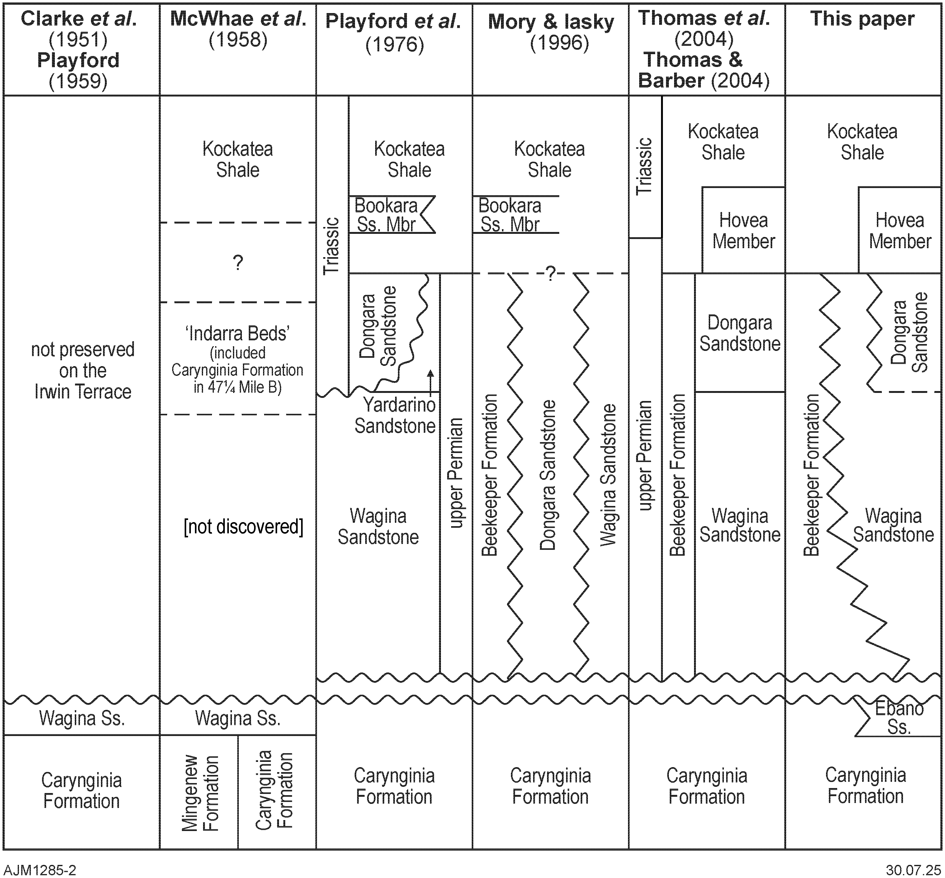
The name ‘Wagina Sandstone’ is commonly applied to extensive upper Permian shoreface to shallow marine siliciclastic facies that lie unconformably above lower Permian strata and conformably below the uppermost Permian Dongara Sandstone and Triassic shale in the subsurface of the northern Perth Basin (summarised in Playford et al. 1976; Mory & Iasky 1996; Mory et al. 2015). By contrast, early reports on the outcrop belt within the Irwin Terrace along the eastern margin of the basin mostly considered the Wagina Sandstone to be conformable on the underlying Carynginia Formation (Clarke et al. 1951; Playford & Willmott 1958*; McWhae et al. 1958; Playford 1959) and, apart from Playford & Willmott (1958*), favoured an Artinskian age for both units presumably based on the lack of an obvious break and age-diagnostic fossils. Nevertheless, Johnson et al. (1950, 1954) and Dickins (1963, p. 20) were ambiguous about this relationship, and Playford & Willmott (1958*) indicated an uncertain age within the Permian for the Wagina Sandstone. Based on spore-pollen assemblages from the shallow core hole University of Western Australia 4 (UWA 4) drilled into the top of the reference section of the Wagina Sandstone, Balme (1964a) concluded that the formation is late Permian in age. His later suggestion that this microflora resembled those from between the Carynginia Formation and Triassic Kockatea Shale in the first petroleum exploration wells in the region (in McTavish 1964a*; Pearson 1964*) led to the widespread application of the name Wagina Sandstone to dominantly sandstone facies of late Permian age in the subsurface west of the outcrop belt. The unusual situation of having a conformable relationship on the eastern margin of the basin rather than an unconformity or disconformity in the deeper part of the basin was not only ignored but it was then assumed that Wagina Sandstone in the outcrop must also be unconformable on the Carynginia Formation (e.g. Playford et al. 1976; Le Blanc Smith & Mory 1995; Mory & Iasky 1996). This paper seeks to resolve these stratigraphic conflicts with newly processed palynological samples from UWA 4, which is the only core hole containing an unoxidized section unambiguously from the Wagina Sandstone within the Irwin Terrace.
Geological setting
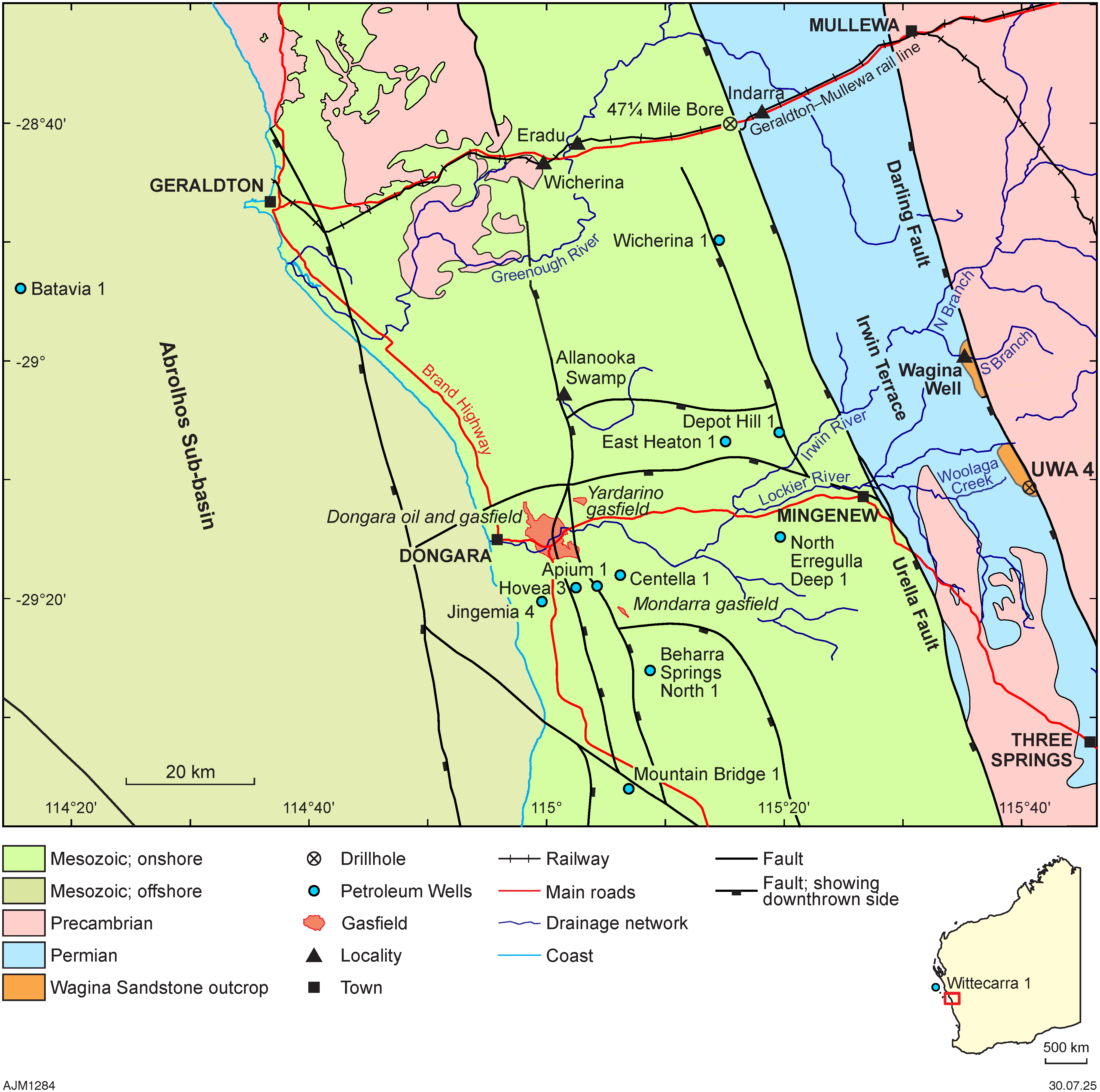
In the northern Perth Basin, the Irwin Terrace (Hocking 1994), formerly the Irwin Sub-basin of Playford et al. (1976), encompasses an elongate NNW-trending belt of folded and faulted Permian strata between the Urella Fault and Precambrian rocks east of the Darling Fault (Fig. 1). The older term ‘Irwin Basin’ as used by Clarke et al. (1951) and Johnson et al. (1954) appears to also refer to a modern physiographic province. The main depocentres in the basin lie west of the Urella Fault and are characterised by thick Mesozoic sedimentary deposits above the Permian whereas the Irwin Terrace lacks Mesozoic sections.
The Irwin Terrace, which contains the main Permian outcrops of the northern Perth Basin, is where many of the Permian formations now in use were defined by Clarke et al. (1951) before they were recognised in the subsurface west of the Urella Fault after petroleum exploration drilling commenced in the 1960s. This includes the name Wagina Sandstone, which has been widely applied to upper Permian siliciclastic facies in about 150 petroleum wells and over 50 published papers on the petroleum geology of the region. Clarke et al. (1951 p. 67–68) designated the type section of the Wagina Sandstone along the South Branch of the Irwin River near Wagina Well at 28°59’42"S, 115°35’11"E; however, Playford & Willmott (1958, p. 63–64; and in McWhae et al. 1958, p. 78), considered this exposure poor and nominated a reference section near Woolaga Creek, 22 km to the south. Playford (1959, p. 23–24) indicates that section runs between Red Hill (at 29°11’06"S, 115°40’20"E) to the centre of a small syncline next to the Darling Fault (at 29°10’45"S, 115°40’45"E), and is the youngest part of the Permian preserved along the Irwin Terrace. Over two kilometres have been eroded from this section, based on Le Blanc Smith & Mory’s (1995, p. 38) estimated depth of burial for the Irwin River Coal Measures within the sub-basin.

Significance of UWA 4
To date, UWA 4 has yielded the only productive samples for palynology from the Wagina Sandstone within the outcrop belt between the Darling and Urella faults. Despite intense coal exploration drilling north of the Lockier River between 2004 and 2017 by Austral Iron, AP Mining and Westralian Iron, no other intersections of the formation can be verified, or, if they do exist, they are shallower than 20 m within intervals described as highly oxidised in the company reports.
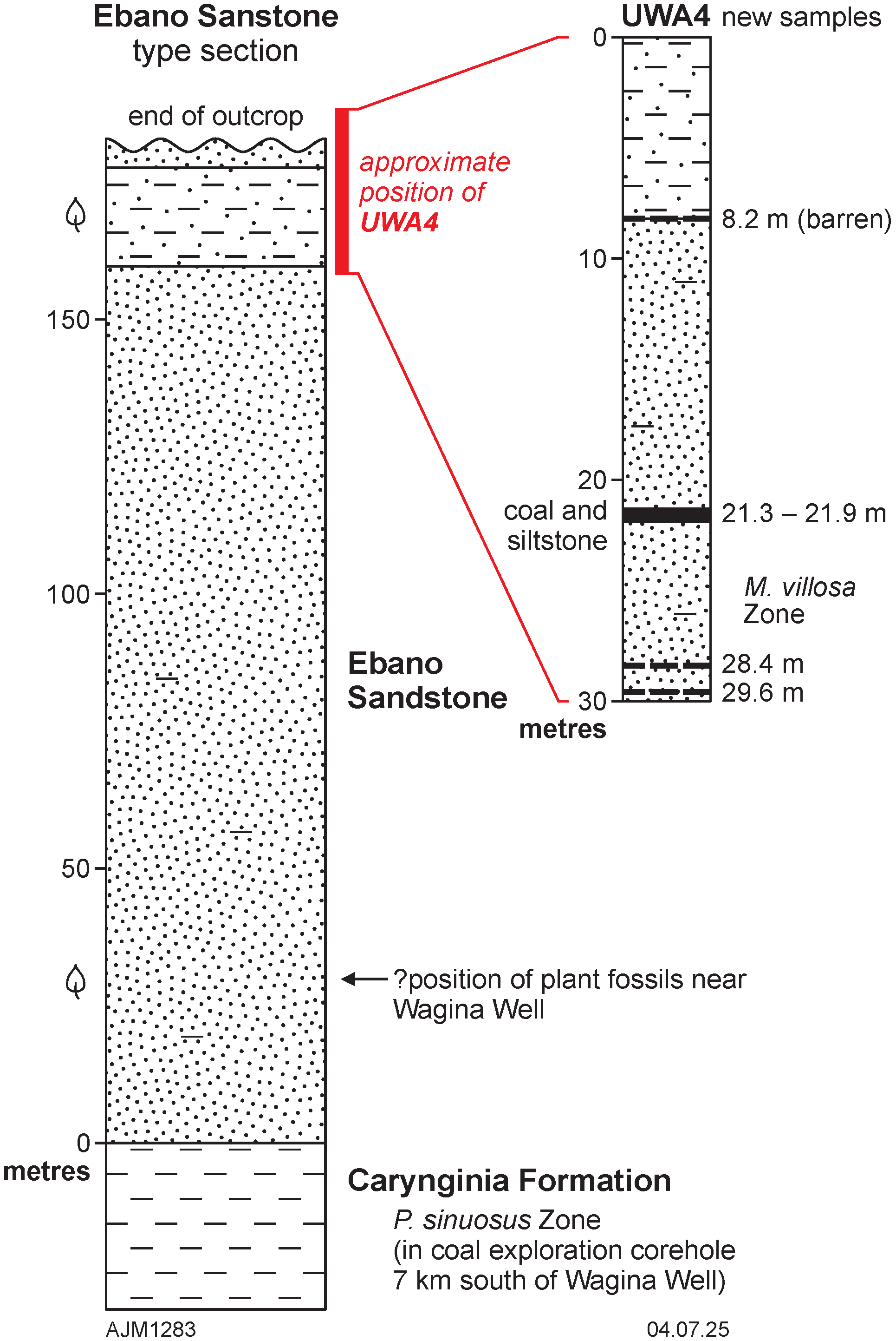
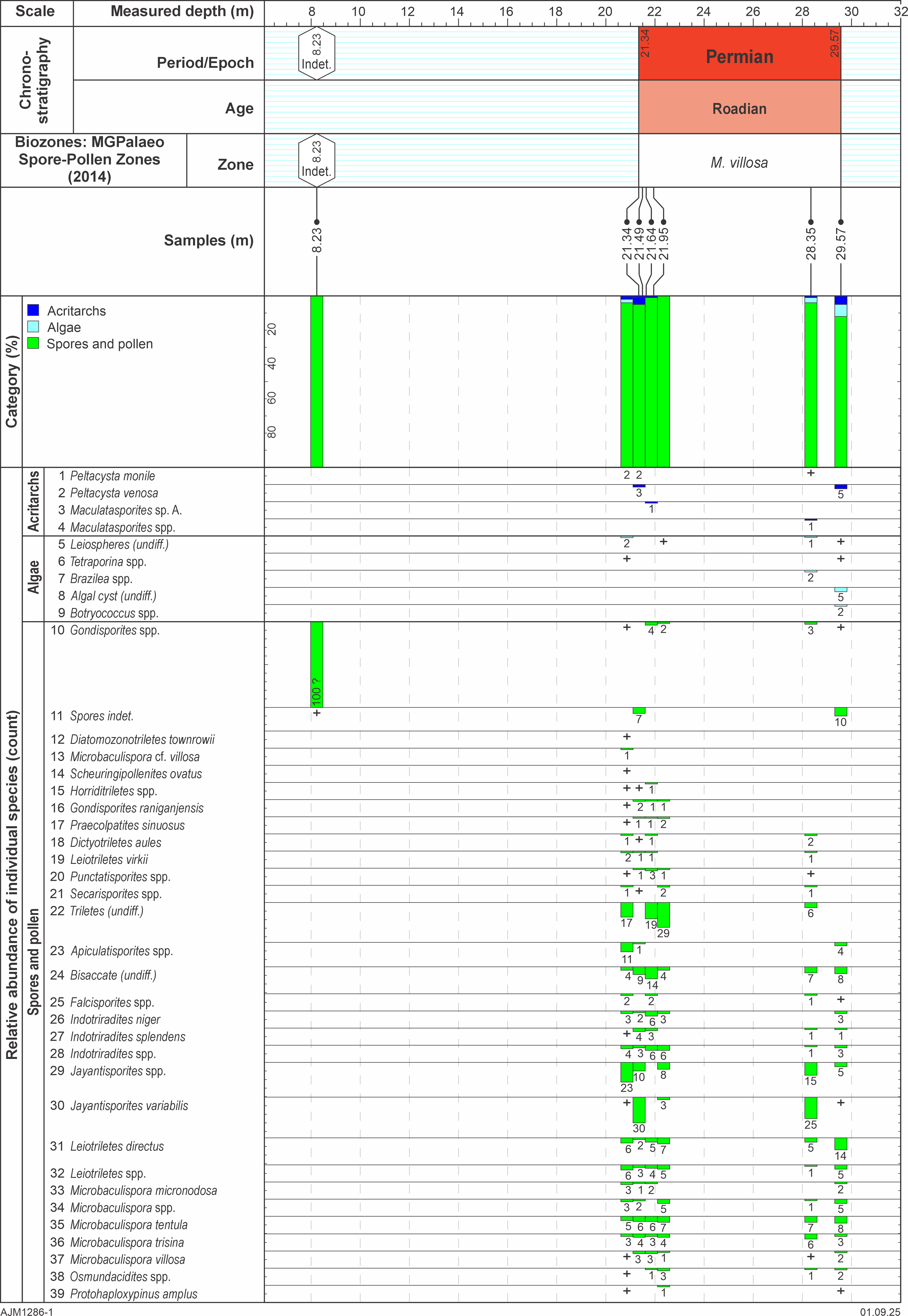
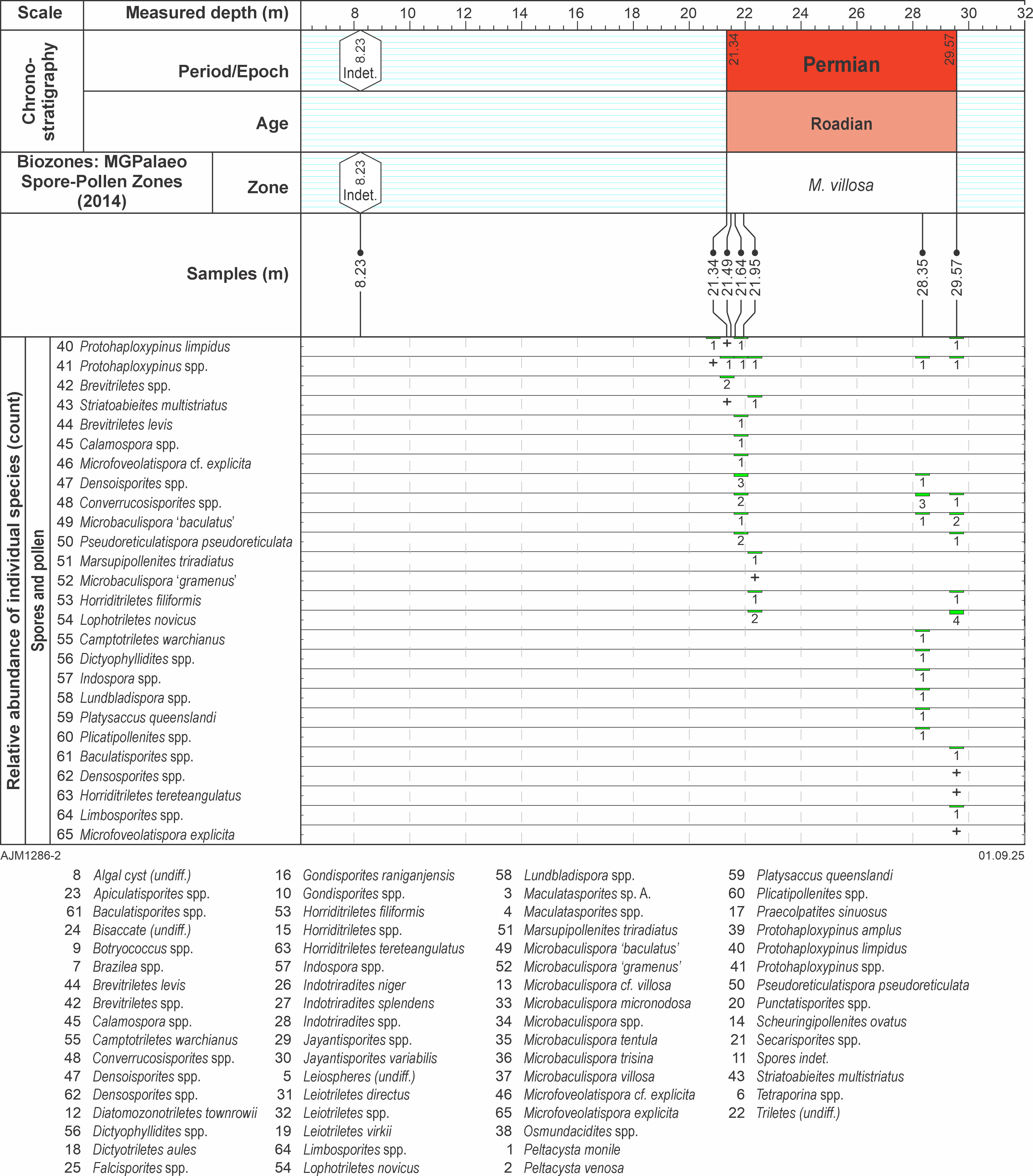
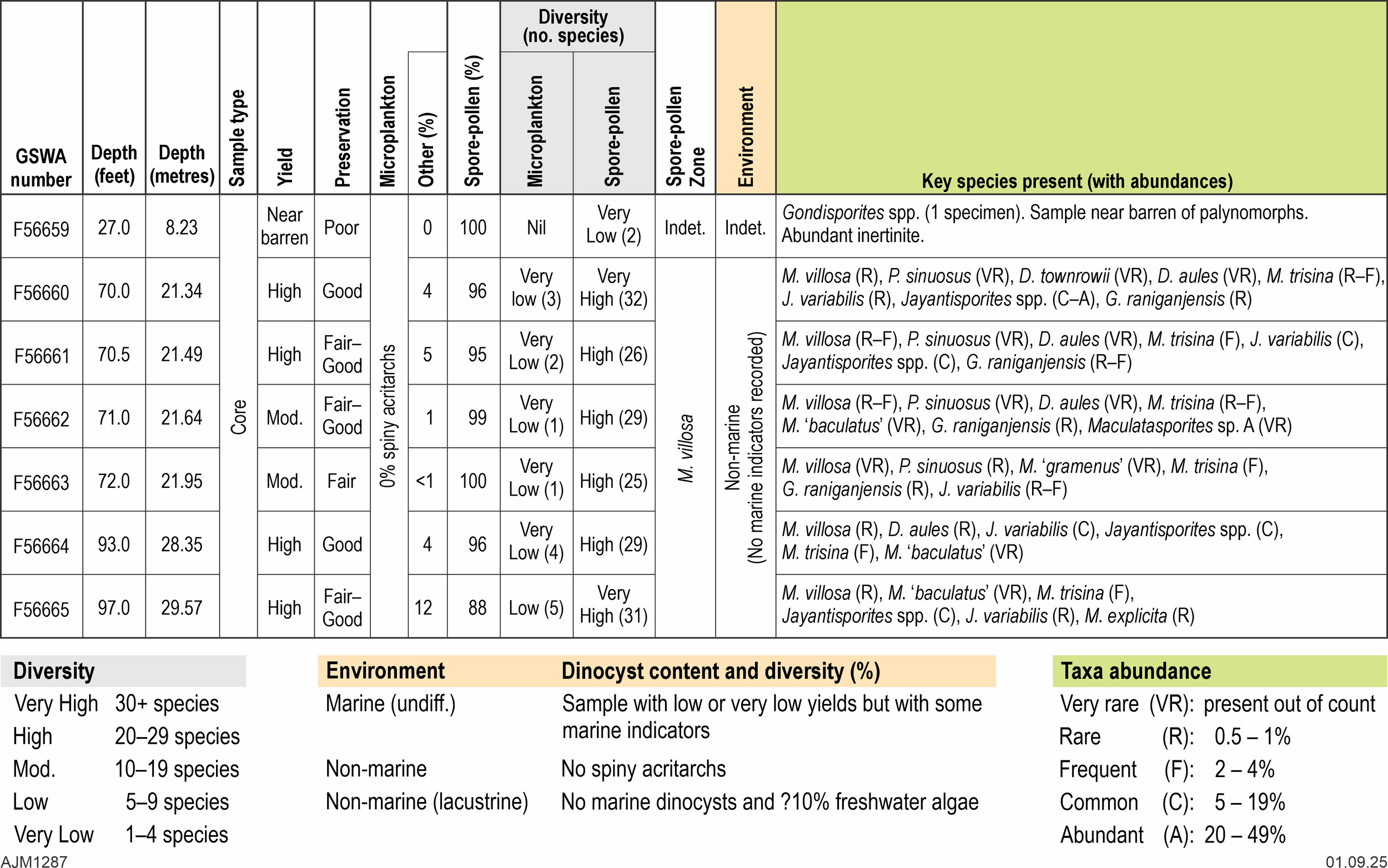
UWA 4 was drilled to about 30 m into the Wagina Sandstone close to the top of the reference section during April 1964 at about 29°10’40"S, 114°40’40"E based on Balme’s (1964a) description (Fig.2). The drill site presumably was chosen to be close to the plant fossil beds that Playford (1959, p. 25) discovered near the upper limit of the outcrop approximately 160–177 m above the Carynginia Formation. The ~3 cm diameter core is fragmented with few depths marked (in feet) and recovery was no more than 20% based on what is in the core tray, so sample depths are approximate. The missing intervals probably correspond to poorly consolidated sandstone. Seven siltstone samples spanning 8.2 to 29.6 m (Table 1) were processed for palynology following standard procedures at MGPalaeo’s Malaga laboratory. Balme’s (1964a) samples were mostly from the sapropelic coal between 21.3 and 21.9 m based on depths in the UWA Geology Museum catalogue, as opposed to those provided in his paper (28–29.3 m), whereas Backhouse’s (1993a) sample was from a siltstone at 27.7 m.

Permian spore-pollen zones
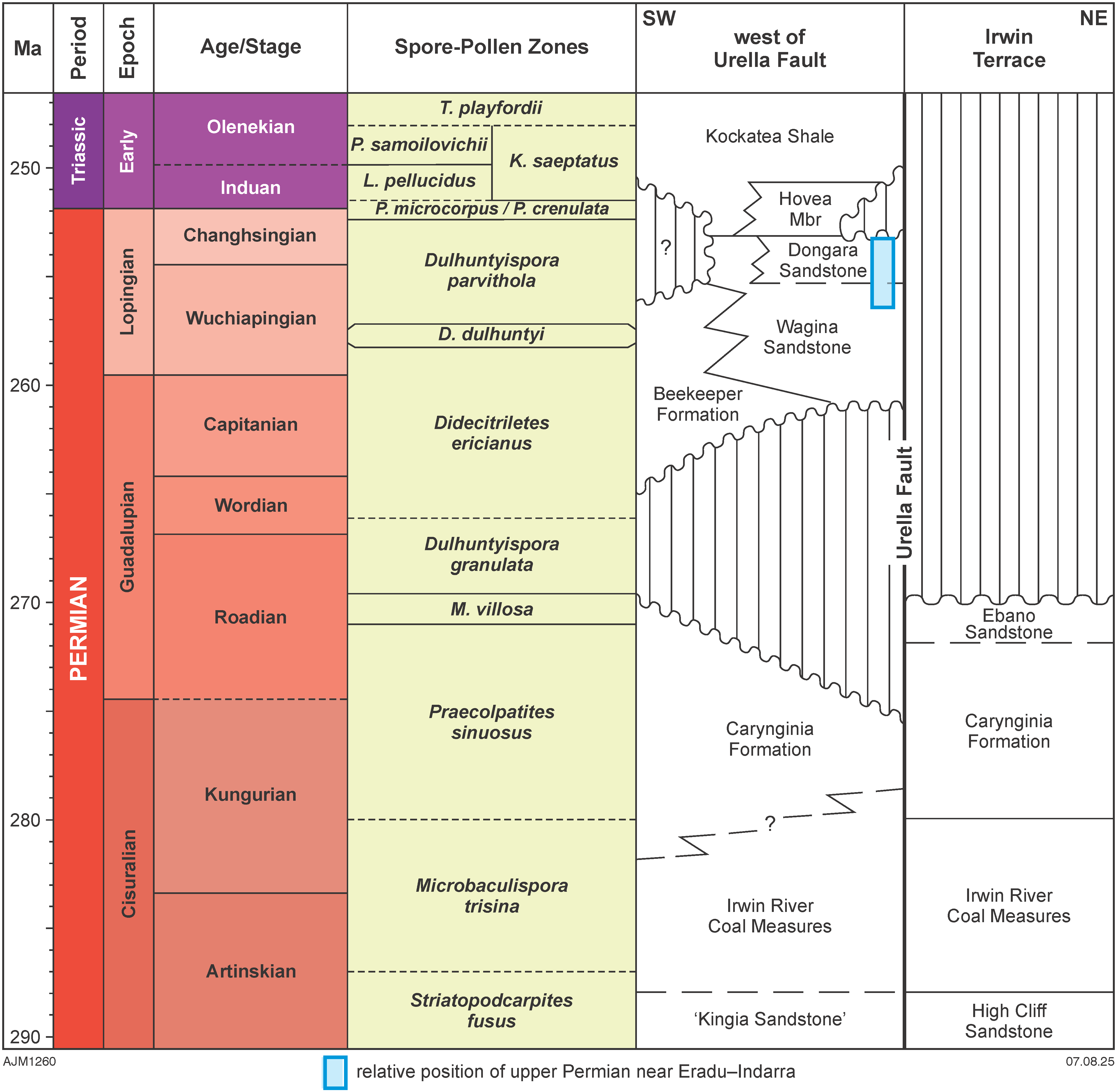
Spore-pollen zones (e.g. Kemp et al. 1977; Backhouse 1991, 1993a, 1998; Foster & Archbold 2001) are typically used to aid Permian correlations in the northern Perth Basin as significant non-marine or restricted marine intervals hinder age determinations based on marine fossils. Of the 12 spore-pollen zones recognised in the Permian of Western Australia, eight cover the late Artinskian to end Permian (Carynginia Formation to lowermost Kockatea Shale, Fig. 3) discussed in this paper. Although the zonation is largely dependent on first appearances of provincial species, the Guadalupian to Lopingian part is calibrated to international stages using chemical abrasion-isotope dilution thermal ionisation mass spectrometry (CA-IDTIMS) dating of zircons from volcanic tuffs, albeit mostly from eastern Australia (Laurie et al. 2016). Their study revised the age of most mid- to upper Permian zones upwards compared to earlier estimates, with the most significant shift being the base of the Dulhuntyispora parvithola Zone from about 263 Ma to 257.4 Ma. In the case of the Microbaculispora villosa Zone (APP3.3, Stage 4b of Kemp et al. 1977), its age shifted from the earlier estimate of late Kungurian–early Roadian (Mantle et al. 2010), to entirely within the Roadian (Laurie et al. 2016). Mory et al. (2017) later reported late Roadian CA-IDTIMS dates of 267–268.4 Ma associated with this zone in the Canning Basin, which at the time were considered early Wordian; however, these ages conflicted with slightly older dates (~269 Ma) associated with the purportedly overlying D. granulata Zone. This discrepancy was explained by local depositional conditions overriding the general succession of spore-pollen species but nevertheless highlights uncertainties in establishing ages from these fossil assemblages.
In the northern Perth Basin, the mid-Roadian M. villosa Zone is found within the upper Carynginia Formation in just four petroleum exploration wells: Batavia 1 (SWC at 2824 m), East Heaton 1 (SWC at 2271 m), Mountain Bridge 1 (SWCs from 2680–2693 m) and Wittecarra 1 (SWC at 2838 m). The overlying succession contains the Wordian to early Wuchiapingian D. ericianus Zone and mid-Wuchiapingian to Changhsingian D. parvithola Zone. The D. granulata Zone between these zones is missing in the northern Perth Basin, presumably coinciding with the unconformity between the Carynginia Formation and the overlying upper Permian succession.

Plant macrofossils in the Wagina Sandstone
Johnson et al. (1954, p. 51) suggested that the fossil plant horizon in the type section of the Wagina Sandstone lies approximately 30 m (100 feet) above carbonaceous shale that was later mapped as the Carynginia Formation by Le Blanc Smith & Mory (1995, plate 1). The plant fossils material from the formation have been described by Rigby (1966) and McLoughlin (1992, 1995). In his description of Bergiopteris sp. cf. B. archangelskyi from this unit McLoughlin (1995) notes that other Australian occurrences of this pinnate frond species are Sakmarian and are comparable to Sakmarian or Artinskian Argentinian forms. By comparison, Rigby (1993) opted for a Kazanian age, which at the time was considered equivalent to the entire Guadalupian; however, Leonova (2007) equates the Kazanian with the Roadian. Changes to the absolute ages of Permian stages and the relative position of spore-pollen zones in Australia based on improved radiometric dating, mostly of zircons, point to a Kungurian–Roadian age for these macrofloras. However, these ages are uncertain given the scarcity of Cisuralian zircon dates within Australia to better calibrate spore-pollen zones against international stages as resolved by Laurie et al. (2016) for the upper Permian.
PALYNOLOGICAL ASSESSMENT OF UWA 4
Processing
Seven new samples from UWA 4 were processed for palynological analysis using the standard preparatory techniques outlined by Phipps & Playford (1984) and Wood et al. (1996). The samples, weighing between 12 and 26 g, were scrubbed and washed to remove any drilling additives or modern spore-pollen contaminants. They were then crushed to a 2–5 mm diameter grit and immersed in 30–50 ml of hydrochloric acid (32%) to remove any calcareous minerals. The hydrochloric acid reactions were negligible, and only a short maceration time (~two hours) was allowed for each sample, which were then left overnight in 30 ml of cold hydrofluoric acid (48%) to remove most of the siliciclastic minerals. Following neutralisation, the organic portion was separated from any remaining heavy minerals in a lithium heteropolytungstate solution set to a specific gravity of 2.1. The resulting organic float was neutralised again before filtering through a 10 µm nylon sieve to remove fine organic particles. This final kerogen fraction underwent moderate oxidation (180 sec) in nitric acid (69%), followed by a final neutralisation with sodium hydroxide, and finally the residue was mounted on glass slides for microscopic analysis. The slides for the seven samples are registered in the Geological Survey Western Australia (GSWA) Palaeontology Collection as F56659–65 (Table 1).
Results
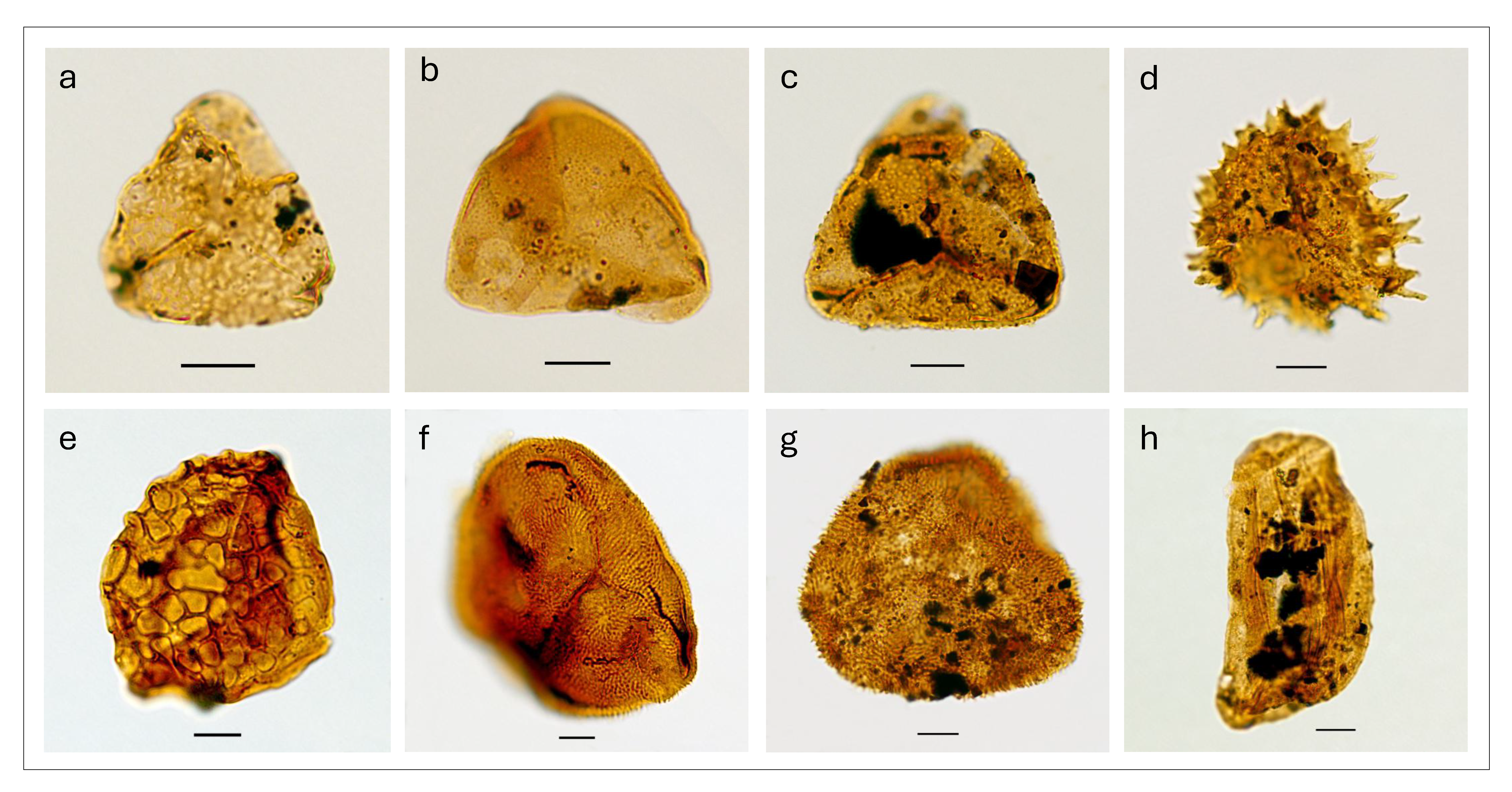
Six of the seven core samples produced moderate to high organic fossil yields (Tables 1, 2); the shallowest sample from 8.2 m contained abundant inertinite but was near barren of palynomorphs and could not be assigned an age. The six productive samples (21.3 m, 21.5 m, 21.6 m, 21.9 m, 28.4 m, and 29.6 m) contained fully terrestrial assemblages dominated by fern and lycopsid spores along with subordinate gymnosperm bisaccate pollen (mostly derived from Glossopteris species), and rare to frequent freshwater acritarchs and algae (including Botryococcus sp., leiospheres, Peltacysta spp., and a Tetraporina sp.). The rare to frequent presence of Microbaculispora villosa (formerly Acanthotriletes villosa) in all six samples and the absence of any younger spore-pollen index species, principally the lack of Didecitriletes ericianus or Dulhuntyispora, restricts these samples to the M. villosa Zone. Other stratigraphically useful accessory taxa include Dictyotriletes aules (21.3 m, 21.5 m, 21.6 m, 28.4 m; with a regional first appearance in the uppermost Praecolpatites sinuosus Zone), rare to common Jayantisporites variabilis (in all six samples; species typically rare above the Didecitriletes ericianus Zone), and two informal taxa, Microbaculispora “gramenus” (22 m) and M. “baculatus” (21.6 m, 28.4 m, 29.6 m) that are rarely recorded beyond the P. sinuosus to D. granulata zones. Examples of these taxa are illustrated in Figure 4. In all samples the spore-pollen are orange–brown indicating sufficient burial to generate oil and gas from organically rich intervals (Jiang et al. 2016), i.e. between one and possibly three kilometres of strata have been eroded from the succession preserved next to the Darling Fault.
_*microfoveolatispora_exp.png)


HISTORY OF ‘UPPER’ PERMIAN STRATIGRAPHIC NOMENCLATURE
Irwin River – Woolaga Creek outcrops
The first mention of the sedimentary succession that was eventually called the Wagina Sandstone by Clarke et al. (1951) was by Campbell (1910, p. 29) who referred to ‘argillaceous sandstones [in] the upper portion of the series’, at a time when the entire Permian section was considered Carboniferous in age and known only from outcrop between the Urella and Darling faults (Fig. 1). Teichert (1941, p. 378) described this part of the succession as ‘whitish and grey fine-grained sandstones and shales from which no fossils have yet to be found …’ and suggested an Artinskian age (in his fig. 6), presumably based on its stratigraphic position. Clarke et al. (1951) defined the formation and designated outcrop along the South Branch of the Irwin River near Wagina Well as the type section, thereby incorporating a nearby, then newly found, plant fossil locality. However, Playford and Willmott in McWhae et al. (1958) considered this exposure poor and nominated a reference section near Woolaga Creek, 22 km to the south, where Playford (1959, p. 24–25) found a carbonaceous siltstone containing plant fossils about 160–180 m above the Carynginia Formation (Fig. 2). In 1964 UWA drilled a shallow core hole (#4) just east of that plant locality allowing Balme (1964a, p. 83) to extract spores and pollen from a canneloid coal not evident in the outcrop. He “…strongly suggest[ed] that the unit is upper Permian, although a ‘Kungurian’ age is not entirely out of the question.” In ensuing papers Balme & Segroves (1966) and Segroves (1967a, 1970, 1972) emphasized a late Permian age when formally describing this palynological assemblage (along with material from other localities). The most recent palynological review incorporating the UWA 4 microflora accepted that age although the species list (Backhouse 1993a, fig. 11) lacks evidence for an age younger than the Kungurian – early Roadian P. sinuosus Zone.
Eradu–Indarra area
Drilling into the upper Permian for water and coal in this area commenced in the 1900s at the 47¼ mile peg on the Geraldton–Mullewa railway line west of Indarra and then for coal at nearby Eradu (Fig. 1) presumably encouraged by nearby carbonaceous outcrops along the river. Exploration interest in Eradu continued into the 1920s, mostly for coal (Campbell 1910, p. 31–32; Blatchford 1930; Johnson et al. 1954, p. 59 and appendix), and revived in the 1960s with drilling for water and then coal in the 1980s. Although the succession was first correlated with the Artinskian–Kungurian Irwin River Coal Measures (Clarke et al. 1951), its age was not determined until the late 1950s (Balme reports in Playford 1957*). The Permian in the 47¼ Mile Bore from ~290 m to total depth at 432 m (950–1418 feet) was named as the type section of the ‘Indarra Beds’ by Playford (1957*) and Playford & Willmott (1958*; in McWhae et al. 1958, p. 79, table V on p. 54) at a time when the Wagina Sandstone in the outcrop belt was considered significantly older. However, these workers ignored the use of ‘Eradu Coal Measures’ by Johnson et al. (1954) and were ambivalent regarding Balme’s use of ‘?Wagina Sandstone’ and ‘Eradu Beds’, and his identification of the Carynginia Formation, in the 47¼ Mile Bore (table 1 in Playford 1957*, appendix II; Fig. 5).
Drilling in the Eradu area briefly resumed in the 1960s for its water resources (summarised by Swarbrick 1964) but was abandoned after a better supply was found in Jurassic sandstone near Allanooka Swamp (Allen 1980). In addition to the 47¼ Mile Bore, about 40 water bores near Eradu intersected the ‘Indarra beds’ (Swarbrick 1964, plate 6). Little palynology accompanied the hydrogeological drilling near Eradu, but Segroves (1967b*) later included samples from several of those wells in his palynological investigation. Eventually Playford et al. (1976) discarded the name ‘Indarra Beds’ as used by Balme (1963, p. 37; 1964b, p. 65) in favour of Wagina Sandstone. Few cores and cuttings have been retained from Eradu, none of the water or coal bores drilled before the 1970s had wireline logs, and the available palynology from this drilling needs a revision.
Despite Johnson et al.‘s (1954) suggestion that the coals near Eradu were too inferior to justify further investigation, exploration revived briefly in the 1980s (e.g. Denman & O’Neil 1981*; Wilkinson 1987*; Clark & Griffith 2013*) and confirmed the substandard quality of the coal. The 1980’s exploration included drilling with wireline logs and palynology, which indicated the presence of the D. parvithola Zone, and possibly the D. ericianus Zone, within the succession (Balme in Denman & O’Neil 1981*; Purcell in Wilkinson 1987*). Since then, the only palynological reassessment of the area (Backhouse 1993a, fig 11) was restricted to samples from 347.5 m in the 47¼ Mile Bore and 58.2–111.9 m in Wicherina X49 within the Eradu–Wicherina area close to the Greenough River, and indicated the D. parvithola Zone, i.e. a Lopingian age, for the succession. However, that revision did not extend to deeper units which Swarbrick (1964) and Segroves’ (1967b*) assigned to the High Cliff Sandstone and Holmwood Shale in bores near Eradu, and to the Carynginia Formation below 363 m (1190 feet) in the 47¼ Mile Bore. The succession in this area appears to be entirely non-marine (e.g. Mory et al. 2005, p. 32) with thicker mudstone and coal intervals in the subsurface than in petroleum wells to the south near Dongara where the coeval facies are shoreface to shallow marine (e.g. Tupper et al. 1994). Use of ‘Indarra’ or ‘Eradu’ as stratigraphic terms away from these locations is not recommended especially given the identification of the Carynginia Formation in the 47¼ Mile Bore.
Subsurface west of the Urella Fault
The name Wagina Sandstone was first applied to subsurface sections west of the Urella Fault in two West Australian Petroleum (WAPET) exploration wells: Wicherina 1 (McTavish 1964a*) and Yardarino 1 (Pearson 1964*). This assignment was guided by the stratigraphic position of the formation above the Carynginia Formation and the apparent similarity of the palynoflora to that described from UWA 4 by Balme (1964a). In the succeeding evaluation report for Wicherina 1, McTavish (1964b*) instead applied ‘Indarra Formation’ to this succession, following Playford & Willmott (in McWhae et al. 1958, p. 79); however, this appears to be the only use of that name in a petroleum exploration well within the basin.
In Yardarino 1, Pearson (1964*) divided the Wagina Sandstone into an upper (Unit A) and lower (Unit B) sandstone. Unit A was later named the ‘Basal Triassic Sandstone’ (Johnstone & Willmott 1966; Hosemann 1971; Bergmark & Evans 1987) and then the ‘Yardarino Sandstone’ (McWhae 1967*) with the type section nominated by Playford & Low (1972, p. 45) as 2284–2307 m in Yardarino 1. Whereas the ‘Yardarino Sandstone’ was regarded as a member of the Wagina Sandstone by Playford et al. (1976, p. 113), they renamed the ‘Basal Triassic Sandstone’ in the Dongara field as the ‘Dongara Sandstone Member’ of the Kockatea Shale with a type section spanning 1682–1701 m in Dongara 11 (p. 123; Fig. 5). In this regard they followed the unpublished report by McKellar (1972*), which appears to be the first use of Dongara Sandstone. With subsequent drilling of that reservoir, at first by WAPET, these units were shown to be entirely late Permian in age (Fig. 5). Mory & Iasky (1996, p. 17–18) pointed out that the Wagina Sandstone ‘… east of the Urella Fault is a pebbly sandstone of fluvial origin, whereas the upper Permian west of the Urella Fault is largely a bioturbated marine sandstone’. For this reason, they extended the type section in Dongara 11 downwards by 12 m to the top of the unconformably underlying Carynginia Formation at 1713 m. Nevertheless, Mory & Iasky (1996) restriction of the name ‘Wagina’ to the outcrop belt was not widely accepted with many publications following the nomenclature in Thomas et al. (2004) and Thomas & Barber (2004; Fig. 5).

In the original species list for Yardarino 1 (Balme in Pearson 1964*) only one species from core 16 in the upper Permian (Acanthotriletes sp. cf. A. ericianus) indicates the D. ericianus Zone or younger (Backhouse 1992*). By comparison, species listed by Balme (in McTavish 1964a*) from the upper Permian at 512.7 m in Wicherina 1 point to an age no younger than the late Kungurian to early Roadian P. sinuosus Zone; however, Backhouse’s (1993b*) record of Dulhuntyispora parvithola and D. dulhuntyi from the assemblage from 512.7 m confirms a Lopingian (late Permian) age and assignment to the D. parvithola Zone. The Permian age of the Dongara Sandstone was apparently confirmed with the identification of Lopingian palynomorphs (D. parvithola Zone) within the overlying Hovea Member at the base of the Kockatea Shale in six wells drilled between 2001 and 2012 (Apium 1, Centella 1, Ejarno 1, Hovea 3, Jingemia 4 and Mondarra 7). However, it is possible that the Permian palynomorphs within the Hovea Member are reworked (Mantle, 2025). In other wells the Induan P. microcorpus Zone lies just above the top of the Dongara Sandstone suggesting either a diachronous relationship between the two units, or local condensed sequences at the base of the Hovea Member.
Recent attempts to differentiate subsurface units attributed to the Dongara and Wagina sandstones include the CSIRO-developed HyLogger™, a rapid non-destructive logging and imaging system using visible and infrared spectroscopy and digital imaging to examine cores and cuttings that is best employed to identify pale minerals (e.g. Copp et al. 2021), as well as chemostratigraphy and heavy minerals. Of these techniques chemostratigraphy, utilizing bulk rock elemental data, is becoming relatively widely applied to assist correlations using elemental and provenance analyses. Whereas Chemostrat Australia (2021*) recognize six subdivisions in the Wagina Sandstone and up to five in the Dongara Sandstone, which they use to correlate between petroleum wells, their data suggests the two ‘formations’ are similar with no discernible differences in the heavy mineral assemblages or provenance.
CONCLUSIONS
The presence of the mid-Roadian Microbaculispora villosa Zone in samples from UWA 4, drilled into the uppermost, non-marine part of the Permian succession on the Irwin Terrace, indicates a correlation with the upper Carynginia Formation in subsurface sections west of the Urella Fault; however, in that area the name Wagina Sandstone has been applied to unconformably overlying marine sandstone facies. Despite the age difference between the outcrop east of the Urella Fault and subsurface facies west of the fault, and use of the name ‘Wagina Sandstone’ in the outcrop having historical precedence, the overwhelming application of the name in about 150 petroleum wells is such that, following the advice of the convenor of the Australian Stratigraphic Committee, the outcrop sections on the eastern margin of the basin are here renamed as ‘Ebano Sandstone’ to avoid confusion. By comparison, the outcrop and its plant fossils have been described or illustrated in fewer than 20 publications. Near Dongara WAPET applied the names ‘Yardarino Sandstone’ and ‘Dongara Sandstone’ to the upper Permian with the former first defined by Playford & Low (1972) and the latter by Playford et al. (1976). Although use of ‘Yardarino Sandstone’ pre-dates that of ‘Dongara Sandstone’, the latter is more widely used and should be applied to the uppermost part of the Permian siliciclastic shoreface succession characterised by clean sands which contain monazite in the Dongara field. The Appendix summarizes the revisions made herein.
Between Geraldton and Mullewa the upper Permian has been called ‘Indarra beds’ and rarely ‘Eradu Coal Measures’ in early reports, whereas Playford et al. (1976) assigned the succession to the Wagina Sandstone. Few samples have been retained from boreholes in this area and only the coal exploration bores drilled in the 1980s have wireline logs; however, the succession appears to be entirely non-marine, so the designation of Wagina Sandstone in this area is not recommended.
As a rule, ages provided in early publications (not just for the northern Perth Basin) typically need to be re-evaluated before being compared to modern determinations. This is particularly so as, prior to the availability of precise CA-IDTIMS dating of zircons from tuff beds, correlations to international stages were imprecise especially where dependent on macrofaunal relationships using non-cosmopolitan species.
ACKNOWLEDGEMENTS
We thank David Haig (UWA) for prompting our investigation of the Wagina Sandstone; Siri Kellner (UWA) for access to core held at the Shenton Park facility; Fiona Dodd (GSWA) for resolute attempts to locate ancient samples in the Perth Core Library; Cathy Brown (convenor of the Australian Stratigraphic Commission) for her advice; Dennikka Lopresse and Michael Prause for drafting the figures; and Clinton Foster and Darren Ferdinando for reviewing the manuscript. AJM publishes with the permission of the director of the Geological Survey of Western Australia.