
_photograph_taken_by_teichert_(1947__pl._xiii__fig._2)_and_described_as__surface_of_lime.tif)
.tif)
Introduction
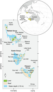
The Wallabi Group of Islands, part of the Houtman Abrolhos archipelago off the central coast of Western Australia (Fig. 1), is the site of the oldest European-built stone structure in Australia. Given its historical significance a replica of the structure has been built at the Batavia Park in Geraldton. Much of the historical discourse presented here is derived from Dash’s book Batavia’s Graveyard (2003) and the archaeological survey done by the Western Australian Museum (Souter et al. 2007). The Dutch East Indies Company (Verenigde Oost-indische Compagnie, VOC) was founded in 1602 to profit from the lucrative spice trade between Europe and what is now Indonesia. Ships sailed around the Cape of Good Hope and took advantage of the strong 'westerlies" to cross the Indian Ocean to the ‘South Land’ (Australia) before turning north to Batavia the then capital of the Dutch East Indies (now Jakarta in Indonesia). The westerlies are the winds which cross the Indian Ocean between 30 and 60-degrees latitude, commonly referred to as the roaring forties. This passage was first adopted by the Dutch in the early 17th century to shorten the passage time from Holland to Batavia replacing the longer route preferred by the Portuguese via their possessions in Goa and Malacca to the Spice Islands. At that time longitudes could not be measured and it was inevitable that some ships sailing blind would run aground on the reefs off the western coast of the ‘South Land’. The VOC ship named Batavia left Texel in the Netherlands on 29 October 1628 destined for Batavia with a complement of 340 comprising crew, passengers, VOC representatives and VOC soldiers. It carried a valuable cargo of trade goods, coins and jewellery and its ballast included stone destined to build a portico for the Batavia fort - later salvaged and re-erected in the Fremantle Maritime Museum. The ship ran aground on the Morning Reef (off the south-east edge of Beacon Island; Fig. 2) in the Houtman Abrolhos Islands off the coast of what is now Western Australia on the night of 4 June 1629. Three hundred survivors managed to reach Beacon Island, a low-lying island with no natural water sources. Francisco Pelsaert the VOC upper merchant and nominally master in charge of the Batavia conducted a quick unsuccessful search for water on nearby islands including East Wallabi Island where shallow holes dug into coastal sand only penetrated brackish groundwater. East Wallabi Island is more easily accessible by sea than West Wallabi Island because of fewer surrounding reefs (refer Fig. 2) a factor which influenced subsequent events.

Pelsaert departed for Batavia on 8 June in the ship’s longboat with 47 of the survivors, ostensibly to look for water on the mainland 80 km to the east but it appears his main motivation was to reach Batavia to report on the loss of valuables and mount an expedition to recover them. By the time of his return and after a month of salvage efforts he departed back to Batavia on 15 November 1629 carrying the remaining 74 survivors of the shipwreck. They had occupied the islands for 142 days and were the first Europeans to spend more than a few days on the ‘South Land’ surpassing Dirk Hartog who spent three days on Dirk Hartog Island also off the coast of Western Australia in 1616.
This paper aims to (1) identify the rock material used in the fort structure on West Wallabi Island, (2) discuss how the ready availability of this material facilitated the quick construction of the fort, and (3) clarify the position of the fort, partly using the presence of gnamma holes, and discuss its relationship to a second pre-1900 stone structure on West Wallabi Island, and (4) the hydrogeological evidence from both West and East Wallabi Islands.
PHYSICAL CHARACTERISTICS OF THE WALLABI ISLANDS
Geology
Teichert’s (1947) description of the geology of East and West Wallabi islands noted (1) a foundation of coral reef limestone, (2) in places an overlying layer (< 1 m thick) of shell limestone with rare corals, and (3) dune limestone with cross-bedding and rhizoliths, that rests on the shell limestone platforms with base between 1.5 and almost 3 m above present sea-level, and up to 10 m thick. For West Wallabi Island, Teichert (1947, p. 175, 1976) noted that “limestone of the central part of the island, which reaches the coast in low cliffs south of the easternmost promontory of the island, is very monotonous (e.g., Fig. 3b)”. As on East Wallabi Island (Fig. 3a) he observed that this limestone was broken by numerous joints with, in places, the surface resembling a cobble pavement. Collins et al. (1997) recorded a similar stratigraphic succession (Fig. 4) with a core of Wallabi Limestone (formally defined by Cockbain et al. 1975), a dense coral-reef limestone platform formed when sea levels were higher during the Last Interglacial period ca 125 Ka (Zhu et al. 1993). The platforms are +2–3 m in elevation with respect to present-day sea level. The limestone is covered in places by up to 2 m of partly friable eolianite, a wind-blown sand deposit. This succession is capped by calcrete which probably formed in soil covering the earlier Pleistocene deposits when the islands were hills on an extensive coastal plain during the last lowstand of sea-level (the glacial period, ca. 20–10 Ka). The calcrete forms a hard pavement over the island and in places was covered by deposits of phosphatic guano (from bird droppings) which were commercially mined intermittently commencing 1876.
_photograph_taken_by_teichert_(1947__pl._xiii__fig._2)_and_described_as__surface_of_lime.tif)
.tif)
Rainfall
The majority of the survivors were totally dependent on rainfall for their drinking water. The first rainfall records in Western Australia commenced in the 1830s more than 200 years after the Batavia shipwreck but the general pattern of rainfall would not have changed significantly. It was fortunate that the shipwreck occurred at the start of the wet winter season otherwise many would have died from thirst. The wet season extends from June to August with rainfall peaking in July. Current annual average rainfall for the Houtman Abrolhos Islands is about 350 mm but is known to have declined by 10 to 20% in the past decades because of global warming. Pelsaert encountered storms on his return in September 1629 which continued until his departure in early November suggesting that rainfall at that time was higher than seen today and favoured the survivors.
Groundwater
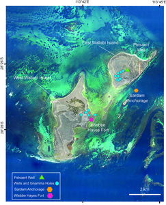
Groundwater on West Wallabi Island is contained within limestone fissures referred to as gnamma holes by First Nations People. A majority of the gnamma holes identified by the Western Australian Museum did not extend down to the water table. The strong tidal fluctuations recorded by Wiebbe Hayes in two gnamma holes he discovered on West Wallabi (Huystee 1994 p. 19) and the low elevation suggest that the maximum thickness of the freshwater lens near the Wiebbe Hayes Fort was no more than 2 m and this thickness would have varied with tidal rise and fall and also seasonally. When Pelsaert returned towards the end of the rainy season the freshwater lens would have thinned and could have turned brackish even without the extra demand from his crew and the remaining mutineers. Porosity and permeability of these aquifers is entirely related to the prevalence and distribution of cavities which appears to be limited on West Wallabi Island.
HUMAN HABITATION
First Nations People
The traditional owners of this area are the Nhanda/Nanda tribes north of Geraldton and the Yamatji/Wajarri/Amangu clans to the south. They would have used gnamma holes on the mainland similar to those found by Wiebbe Hayes on West Wallabi Island for millenia and although there is no evidence of any aboriginal settlement on the Houtman Abrolhos Islands visitation would have been possible by sea and also by foot during the last glacial maximum ca 20,000 years ago when sea levels were 120 to 125 m lower. The Western Australian Aboriginal Sites Register has no registered indigenous sites on West Wallabi (Souter et al. 2007).
The Survivors
As described by Dash (2003) and Souter et al. (2007), Jeronimus Cornelisz the self-elected leader of the survivors after Pelsaert left for Batavia had been planning to mutiny and take possession of the Batavia and its cargo before the shipwreck occurred. He still had illusions that if and when Pelsaert returned he would be able to complete his mutiny but only if he retained his coterie of fellow mutineers and dispensed with the rest. Citing, with some credibility, the lack of water on Beacon Island as his motive 26 survivors were removed to Long Island and a further sixteen to Traitor’s Island all with few exceptions later massacred. The 27 VOC soldiers led by Wiebbe Hayes (the defenders) were dropped on to East Wallabi Island on 20 June again citing the need to find water with the expectation they would not survive given that Pelsaert had already searched there for a water supply unsuccessfully. Nevertheless they were given instruction to light fire signals in the unlikely event that a water source could be found. They were not provided with tools, weapons or a boat. Wiebbe Hayes and his men spent 20 days looking for a permanent water supply on East Wallabi Island without success before wading across a low tide causeway to West Wallabi Island. There they came across two gnamma holes they termed 'pits (Huystee 1994 p70) containing fresh groundwater about 100 m inland. They signalled their success by lighting fires on 9 July at a time when Cornelisz and his henchmen (the mutineers) were busy on their killing spree and indeed had no intention of rescuing the soldiers. Commencing on 15 July several small groups of survivors managed to elude the killers and escaped to West Wallabi Island bringing the total number of survivors there to 47 which was sustainable given the groundwater finds.
LIMESTONE BUILT STRUCTURES
Position of limestone structures
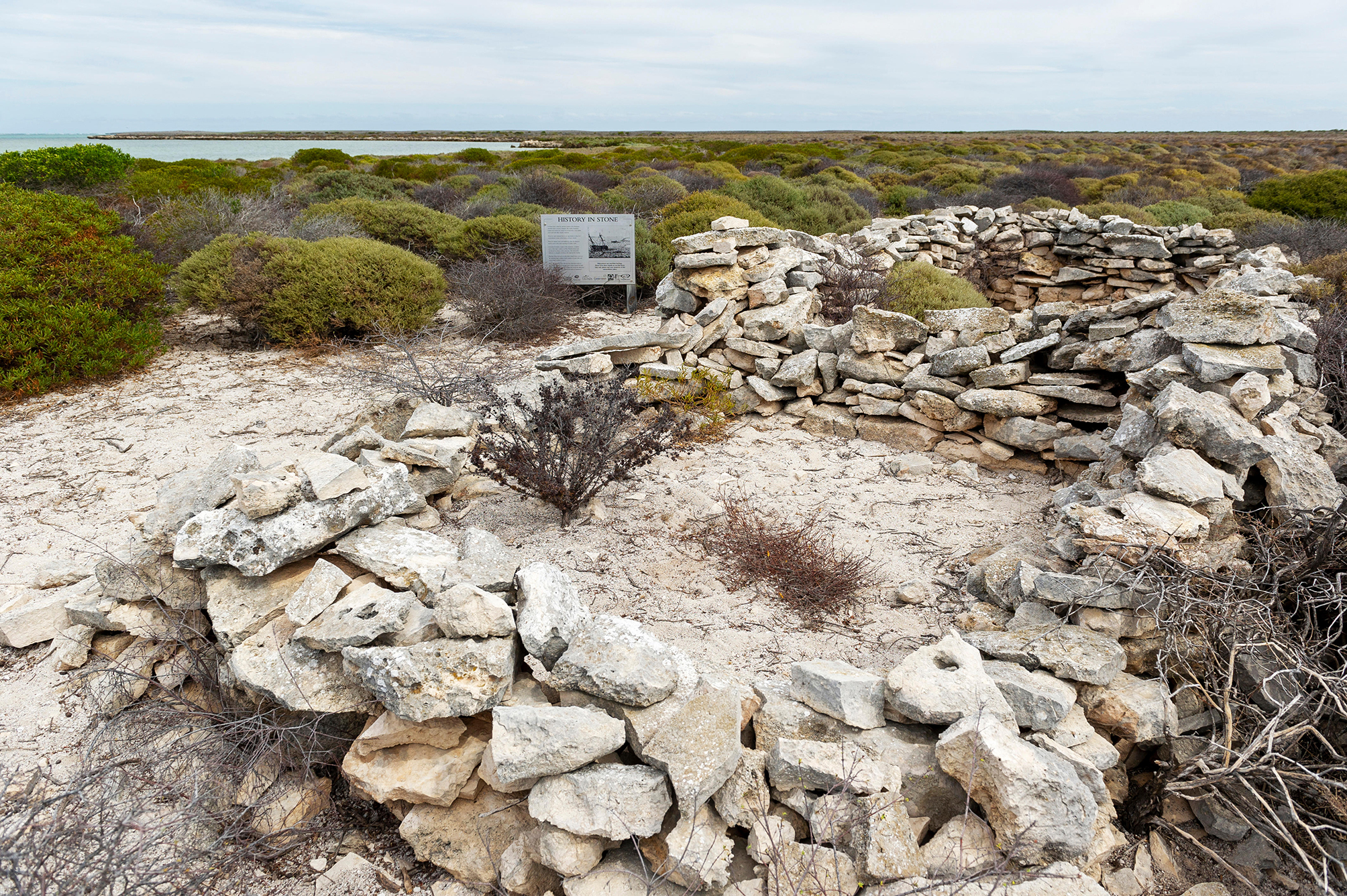
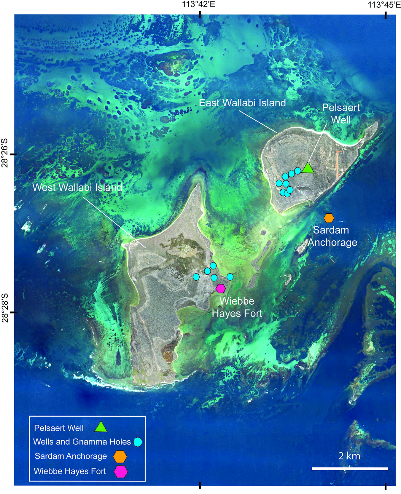
There are two built calcrete structures on West Wallabi, one near the coast (Fig. 5) and a second further inland (Fig. 3b). The coastal structure (28°27′41″S 113°42′15″E; Fig. 3) is near where Wiebbe Hayes and his men first came ashore and located the two gnamma holes. It is recognised as the oldest European structure built in Australia and is named the Wiebbe Hayes Fort. Archaeological studies confirm the artefacts recovered have a connection to the Batavia survivors including barrel hoop-irons and nails (Green and Stanbury 1988). There is a common misunderstanding in the literature that the inland structure because of similar construction and proximity to a groundwater well was also connected to the defenders. However as summarised in the Western Australian Museum archaeological studies (Souter et al. 2007) there is no supporting evidence for that claim. Pelsaerts Journal notes strong tidal fluctuations in both of Wiebbe Hayes gnamma holes (Huystee et al. 1994 p19) an indication they were close to the sea and providing further confirmation that the defenders did not occupy the inland site, the structure there had to be built later. Some historical data (Green et al. 1988 p14) lends further credibility to these findings: "In 1840 Stokes reported that two caverns about half a mile (0.8 km) west of this point contained 3 tons (8.5 kilolitres) of excellent water. He made no reference to any stone structures nor of the two gnamma holes at Wiebbe Hayes Fort to the south of Slaughter Point. In 1843 Gilbert visited the island but failed to locate fresh water and makes no mention of the stone structures. In 1876 L.A. Manning & Co. were granted a lease for two years to remove guano from islands in the Wallabi Group. In 1879 Forrest examined West Wallabi Island for guano deposits. He reported a good well of fresh water and the remains of two old stone huts but does not indicate where these were located". This well must relate to the inland well as Pelsaerts’ Journal mentions that the two gnamma holes at the coastal structure had turned saline in 1629. From its appearance the inland well (Fig. 3b) had been enlarged using tools not available to the defenders.
_constructed_1629___www.alamy.com_(http___www.alamy.c.jpg)
Wiebbe Hayes Fort
As discussed by Dash (2003) and Souter et al. (2007), the arrival of the newcomers fleeing the mutineers in July 1629 made Wiebbe Hayes acutely aware of the killing rampages. Prior to this the defenders would have encamped near the two gnamma holes but after hearing of the massacres he correctly anticipated there would be attacks from the sea and proceeded to build the fort (Fig.5) further south from the gnamma holes in a more commanding and defensible position. Also as a place to manufacture and store rudimentary weapons fashioned out of hoop iron and nails bound to sticks (Huystee 1994 p14). This defensive structure measures 7.9m by 3 m, hardly big enough to house more than a few men. Figure 3 shows that there was no entrance and no windows and the height was limited to a maximum of 1.2 m by the use of dry stone building techniques with no account of canopy. Using the loose blocks of calcrete scattered nearby on the surface as the building material the structure could have been built within a few days towards the end of July 1629 and was instrumental in repelling three attacks despite the superior weapons of the mutineers. The first two attacks required the mutineers to dismount offshore before wading across the mudflats and were easily countered. The third approach was made across the causeway and resulted in the arrest of Corneliusz and the killing of his companions. The final attack was made on 17 September 1629 when the mutineers now less than 20 had armed themselves with guns from the Batavia. By an extraordinary coincidence just when they appeared to be gaining the upper hand Pelsaert appeared on the sloop Sardam ending the insurrection by capturing all the mutineers and executing their ringleaders including Corneliusz (Dash 2003). The Sardam moored off East Wallabi Island (Fig. 6) and the crew initially had to rely initially on Wiebbe Hayes’s two gamma holes for its water supply. However with the greatly increased demand the groundwater had become saline by the end of September. The defenders would then have relocated to the Sardam ending their occupation of Wiebbe Hayes Fort. On 8th October Pelsaert directed fires to be lit on East Wallabi Island to capture wallabies as food supply but also in the hope he could uncover gnamma holes similar to those on West Wallabi. The following is from his Journal (Huystee 1994 pp 83/84). "When they were burning off they have found a well with water, but very stinking. After that, again a pit with brackish water. The next day they found under some burnt shrubs, a small hole that an arm might enter, threw a stone in and noticed that it gave an echo of water. So the skipper has ordered to get pickaxes and crowbars from aboard, with which they have make a hole so big that one could easily scoop out the water. From this well, they filled the ship’s empty water vessels and took them on board". The use of tools to enlarge this gnamma hole created Australia’s first groundwater well of this nature and is here named Pelsaert Well (Fig. 5). Despite the long-elapsed time since Pelsaert first recorded the groundwater in the two gnamma holes as becoming saline they remained brackish.
Significance of calcrete as building material
The calcrete pavement on which the limestone structures were built (see, in particular, Fig. 3), produced a ready and easily worked source of hard limestone blocks for the structures. The calcrete forms a cap on the underlying strata which includes friable (non-cemented) eolianite (Fig. 4). The stone slabs that form the structures would have enabled the fort to be built very quickly to provide a defensive base against attacks by the mutineers. The fort replica in Geraldton next to a statue of Wiebbe Hayes used bioclastic limestone slabs brought from Big Rat Island in the Easter Group of the Abrolhos rather than calcrete from West Wallabi Island.
DISCUSSION
As discussed by Dash (2003), when Wiebbe Hayes stepped ashore on West Wallabi Island he found two gnamma holes and set his encampment there 100 m back from the sea. In July 1629 in response to the threat of attacks from the mutineers he built a small limestone structure now known as Wiebbe Hayes Fort south of the gnamma holes with a commanding position overlooking any sea approaches. Findings of barrel ring-hoops and nails during archaeological excavations at the fort suggest that as well as acting as a lookout it was also used for assembly and storage of the rudimentary weapons to repel the invaders. On the return of Pelsaert when the groundwater in the two gnamma holes became saline the defenders joined Pelsaert on the Sardam ending their occupation of Wiebbe Hayes Fort in September 1629.Many observers (Dash 2003 p216) consider there was only one gnamma hole near the fort with the second at an inland structure. This second gnamma hole appears to have been enlarged using tools not available to Wiebbe Hayes and archaeological excavations there found no evidence of Batavia artefacts. This structure was first seen by Forrest in 1879 after guano mining on the island had formally commenced in 1876 and it can be surmised that the opening of the inland gnamma hole occurred between 1876 to 1879 at the same time as the structure was built.
CONCLUSIONS
The Wiebbe Hayes Fort (28°27′41″S 113°42′15″E) was built in July 1629 using blocks of calcrete and occupied until September of that year making it the earliest European structure built in Australia. It played an important role in repelling attacks from the Batavia mutineers. Its purpose appears to have been both as a lookout post and also as a place to assemble and store rudimentary weapons which were successfully employed against the invaders. A second calcrete structure further inland had no connection to Wiebbe Hayes and was built by guano miners in the mid-19th century. The well created by Pelsaert on East Wallabi Island in October 1629, referred to as the Pelsaert Well in this article, is the first of its type in Australia’s history. First Nations People who had been using similar gnamma holes on the mainland for millenia did not have the tools to enlarge them.
Acknowledgements
Grateful acknowledgement to Dr David Boyer (University of Western Australia) for providing feedback on the archaeological aspects and to the Western Australian and Fremantle Maritime Museums for their support. and to Arthur Mory for his helpful review of the manuscript. Clément Tremblin very kindly redrafted or enhanced the original figures.