INTRODUCTION
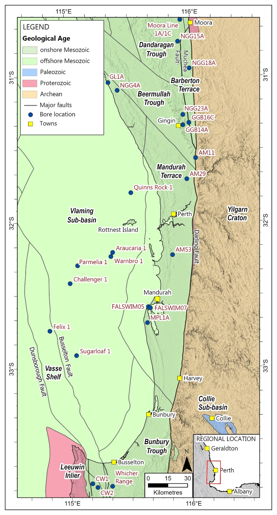
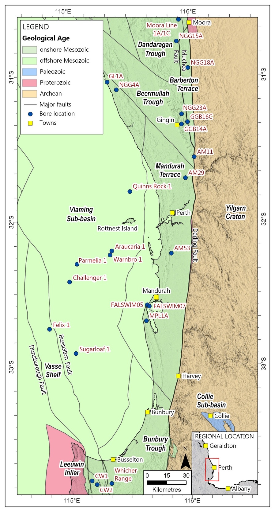
Many boreholes have been drilled for groundwater investigation in the onshore Perth Basin between Moora in the north and the Mandurah area in the south (Davidson 1995; Schafer et al., 2008; Department of Water, 2017*; Department of Water and Environmental Regulation 2020*; Schafer et al. 2025*). Some of these boreholes drilled north and east of Gingin provide the primary evidence for an upper Aptian sedimentary succession that is distinguishable from the Warnbro Group below (see Davidson 1995) and younger Cretaceous strata above (Department of Water 2017*). Strata of this age are also identified in a few boreholes south of Mandurah and some south of Busselton. In the offshore Vlaming Sub-basin there is evidence for strata of similar age in six petroleum exploration wells south of Rottnest Island (Fig. 1) and best demonstrated in Warnbro 1.
Many Australian sedimentary basins with extensive Lower Cretaceous strata contain upper Aptian formations or biostratigraphic units that are clearly differentiated from strata below and above. The best example is the Windalia Radiolarite in the Carnarvon Basin of Western Australia, which is a shallow-water radiolarian-rich mudstone rather than a deep-sea radiolarite (Haig 2005). Fossil evidence suggests the Windalia Radiolarite in the onshore part of the basin was deposited in water no deeper than c.40 m (Haig 2005). This formation has been well dated based on a series of onshore boreholes, notably Barrabiddy 1/1A, by foraminifera (Haig 2005) and palynology (Backhouse in Mory and Yasin 1999). It is distinguished palynologically by the late Aptian Diconodinium davidii Microplankton Interval Zone (Helby et al. 1987), which is confined to the formation. It is succeeded by a thin Muderongia tetracantha Microplankton Interval Zone at the base of the overlying Gearle Siltstone (e.g. Backhouse in Mory and Yasin, 1999).
In the Perth Basin, palynological samples of late Aptian age have been recognised historically in few onshore boreholes. In the past these samples have been placed in the Osborne Formation or sometimes in the Leederville Formation. It can now be demonstrated that there are essentially identical stratigraphic upper Aptian to Albian successions in the Perth and Carnarvon Basins. Similar age units are present in most west Australian sedimentary basins that contain mid-Cretaceous successions. It is proposed to name the upper Aptian unit in the Perth Basin the Moondah Formation.
METHODOLOGY
The primary data for this report is from palynological slides prepared from cuttings samples and sidewall cores (SWCs) collected over many decades by the Geological Survey of Western Australia (GSWA), various petroleum exploration companies and more recently by the Department of Water and Environmental Regulation. Correlation of these boreholes and petroleum wells is supported by wireline logs and lithological data. Palynological slides from over 100 boreholes have been re-examined as part of an ongoing review of this historical data set from the onshore Perth Basin. Samples dated as late Aptian in several old reports prepared mainly in the 1970s and 1980s have been carefully re-examined. Since 1998 additional hydrogeological drilling programs have extended biostratigraphic coverage, especially to areas east and north of Gingin, and areas south of Mandurah.
Sedimentary descriptions of borehole intersections largely depend on hydrogeological reports. Wireline logs are available for most of the deeper boreholes and all the petroleum wells. Even if limited, palynological evidence for the D. davidii Zone in the reviewed data is mentioned herein. In cases where few palynological samples are available assignment to the Moondah Formation also depends on the wireline log interpretation.
GEOLOGICAL SETTING
The Perth Basin is a north–south elongate basin along the southwestern continental margin of Australia. Onshore it extends approximately 1000 km north from the southwestern continental margin to directly east of Shark Bay (GSWA 1990). To the east it adjoins the Archean Yilgarn Craton along the Darling Fault system. Offshore, the basin extends south, west and north to the edge of the continental shelf.
The Lower Cretaceous stratigraphic succession in the Perth Basin (Playford et al. 1976, GSWA 1990) includes a thick interval of Valanginian to lower Aptian Warnbro Group consisting of the Gage Formation, South Perth Formation and the Leederville Formation (in ascending order). The Leederville Formation is now divided into three members in onshore areas close to Perth (Davidson 1995). The relatively most marine unit at the top of the Leederville Formation is the Pinjar Member (Davidson 1995). A stratigraphic unit between the Barremian–lower Aptian Pinjar Member and the lower Albian–Cenomanian Osborne Formation is currently not recognized, although the Dandaragan Sandstone (Playford et al. 1975) is sometimes inserted below the Osborne Formation. As this sandstone is based on highly weathered outcrops lacking a biostratigraphic age that directly underlie the Turonian–Coniacian (Late Cretaceous) Molecap Greensand (Playford et al., 1976), its regional significance is unclear.
Faulting associated with continental breakup during the latest Jurassic to Berriasian affected the pre-Warnbro Group succession, notably in the offshore Vlaming Sub-basin, but also onshore. Post-breakup subsidence yielded greater sediment accommodation offshore than onshore, where thicknesses of the group are usually less than 600 m. However, post-Berriasian uplift and faulting in some onshore areas has affected the distribution of post-Warnbro Group strata.
During the late Aptian shallow inland seas extended across a large portion of Australia’s interior (Haig 2005). The late Aptian (~117–113 Ma) was a time of significant change to tectonic rifting patterns between the Australia, India and Antarctica continents (Williams et al. 2013; Olierook et al. 2020; Asimus et al.; 2025). A slowing of rifting rates between the Australian plate and Greater India as ongoing emplacement of the offshore Kerguelen large igneous province was taking place (Bredow and Steinberger 2018; Jiang et al. 2020) may have reduced the rate at which accommodation was generated in the Perth Basin. Also, a Cretaceous plate tectonic reorganization event, which commenced at the very end of the Aptian, changed the orientation of the Australia–Antarctica plate boundaries (Olierook et al. 2020; Asimus et al. 2025), and may have concentrated sedimentation in the Perth Basin closer to active north–south oriented faults and associated transfer faults during this time.
AUSTRALASIAN MID-CRETACEOUS MICROPLANKTON ZONES
Palynology is the principal method of dating Lower Cretaceous and older Mesozoic subsurface strata throughout Western Australia, particularly in the Perth Basin where few stratigraphic units yield other fossil groups from either borehole samples or the deeply oxidized Mesozoic outcrops. It is also widely used in all other sedimentary basins in Australia. The current Australian zonation established by Helby et al. (1987), encompasses parallel spore-pollen and microplankton zones, Microplankton zones are now usually referred to as dinoflagellate cyst, or dinocyst, zones (Helby et al. 2004, Partridge 2006). This zonal scheme is applied here rather than that of Backhouse (1988) which is widely used for Berriasian to lower Aptian strata in the Perth Basin.
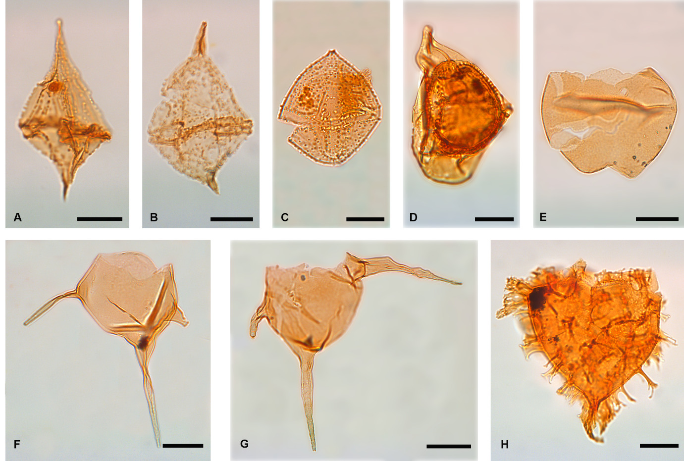
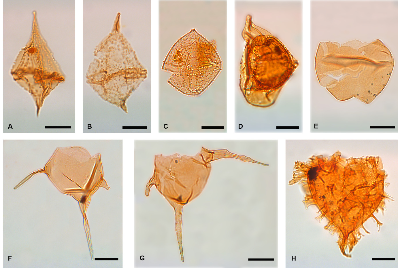
Dinocyst zones are largely based on first occurrence (FO) or last occurrence (LO) of key index species. Most are designated as interval or Oppel zones but referred to herein simply as zones after the initial mention. Several of the mid Cretaceous zones were originally based on reference intervals in eastern Australia and the work of Morgan (1980a). Examples of key dinocyst taxa from the Diconodinium davidii Zone are shown in Figure 2.
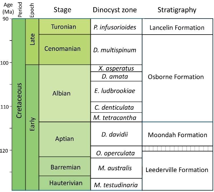
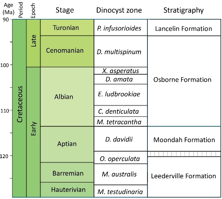
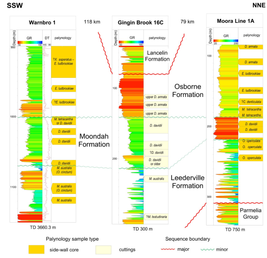
Two zones are particularly relevant to this report. The Diconodinium davidii Interval Zone was defined as the biostratigraphic interval between the FO of Endoceratium turneri and the LO of Diconodinium davidii and the Moondah Formation is biostratigraphically defined by the D. davidii Zone (Fig. 3). Helby et al.'s (1987) reference section is from 217.3 m to 243.8 m in the Bulldog Shale in the Oodnadatta 1 well in the Eromanga Basin of South Australia. The palynology of Oodnadatta 1 was originally described by Morgan (1980a) who assigned this interval to Subzone A of his Pseudoceratium turneri Zone. Similarly, the Muderongia tetracantha Interval Zone was defined by Helby et al. (1987) as the biostratigraphic interval between the LO of Diconodinium davidii and the LO of Muderongia tetracantha, with a reference section in Oodnadatta 1 from 164.6 m to 209.7 m. Morgan (1980a) assigned this interval to Subzone B of his Pseudoceratium turneri Zone. It is now recognised that the dinoflagellate taxon previously assigned to Muderongia tetracantha by Morgan (1980a) is not conspecific with the European taxon of that name. The Australian upper Aptian morphotype is currently referred to as Muderongia tetracantha sensu Morgan (see Davey 1999; Backhouse 2006), but simplified to Muderongia tetracantha in this paper.
Below the D. davidii Zone is the Barremian to early Aptian Odontochitina operculata Oppel Zone of Helby et al. (1987) with significant species changes at the boundary. Marshall and Lang (2013) place the K40 (KA) boundary of the North West Shelf below the upper O. operculata Zone, following Helby et al. (2004) and Partridge (2006). In Perth Basin boreholes and wells this upper part of the O. operculata Zone is not identified and the K40 boundary is placed at the base of the D. davidii Zone, which is also the base of the Moondah Formation. Below the O. operculata Zone the latest Hauterivian to earliest Barremian Muderongia australis Oppel Zone contains dinocyst assemblages that differ little from those of the O. operculata Zone. Both are present in the upper part of the Leederville Formation in the Perth Basin, but the O. operculata Zone is confirmed from relatively few boreholes. The transition from the top of the D. davidii Zone to the M. tetracantha Zone also appears to be a minor sequence boundary with a subtle wireline log signature, but it is unclear how much section, if any, is missing. No sequence boundary is known from the North West Shelf in this position, but it may be too close to the K43 boundary of Marshall and Lang (2013) to be detectable.
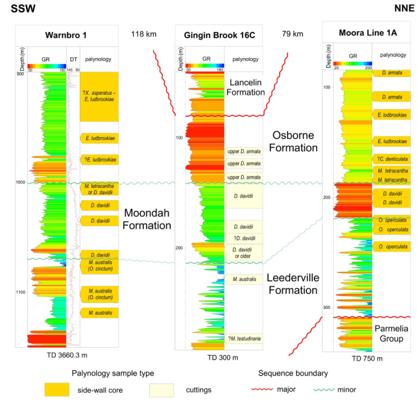
The M. tetracantha Zone is only confirmed from one borehole in the Perth Basin, Moora Line 1A/1C (Fig. 4), where it is probably no more than 10 m thick. Above the M. tetracantha Zone in the Carnarvon Basin is the Canninginopsis denticulata Interval Zone with the boundary marked by a change in dinocyst assemblages. This correlates with the K43 sequence boundary of Marshall and Lang (2013). Immediately overlying the C. denticulata Zone is the Endoceratium (Pseudoceratium) ludbrookiae Interval Zone. This zone and younger Albian zones have an extensive distribution in boreholes in the onshore Perth Basin and southern Vlaming Sub-basin.
MOONDAH FORMATION: TYPE SECTION AND DEFINITION
Type section
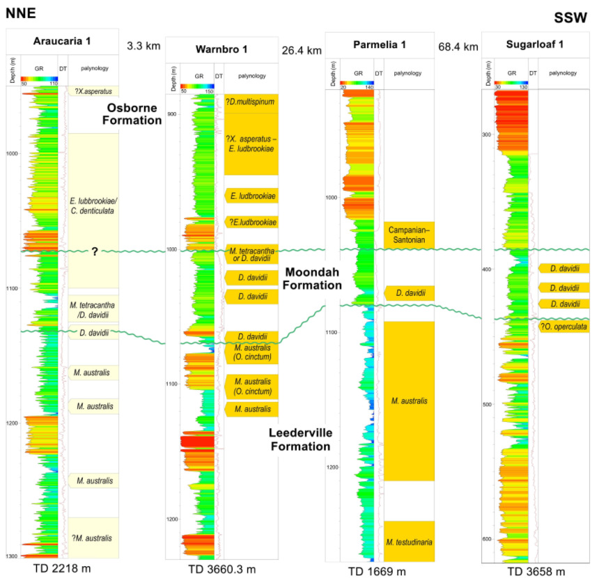
The formation has no known outcrop. The type section is proposed in hydrogeological borehole Gingin Brook 16C (GGB16C) (115.98895°E, 31.32457°S) between 141 m and 213 m below ground level, a thickness of 72 m (Fig. 1). This borehole was drilled in 2017 as part of the Department of Water and Environmental Regulations (DWER) Southern Dandaragan Plateau groundwater investigation project (Filiptsova 2020*, Schafer et al. 2025*) 7.5 km east–northeast of Gingin near Moondah Brook. The formation is defined from lithological information (see below), although this relies on cuttings that do not allow sedimentary structures to be identified, the gamma log signature and palynomorph distributions (which are the main identifiable biogenic components of the rock). The formation boundaries also take into account correlation with other wells, especially Warnbro 1 (Fig. 4).
The lithology of the formation recorded from cuttings samples in the type section from 141 m to153 m is predominantly dark grey, silty claystone, sometimes with brown staining and lignite fragments. From 153 m to 159 m the lithology is similar, but with some coarse sand grains. From 159 m to 194 m dark grey to black or greenish claystone predominates with minor silty intervals. From 194 m a more sandstone dominated interval extends down to 213 m.
Palynomorphs
Identification of the age of the formation is primarily palynological — specifically the presence of key dinocysts of the Diconodinium davidii Zone. Sixteen cuttings samples spanning 112–113 m to 282–283 m from GGB16C were processed for palynology (Appendix 3). As down-hole caving is inevitable in cuttings samples the palynostratigraphy from this section depends on last occurrences (LO) of index species.
The 50 m sample yielded an assemblage assigned to the early Campanian Nelsoniella aceras Interval Zone, whereas the 74 m sample belongs in the mid- to late Coniacian Conosphaeridium striatoconum Interval Zone. Both are from the Lancelin Formation.
The 112–113 m, 123–124 m and 135–137 m samples are assigned to the late Albian upper Dioxya armata Zone. This is based on Craspedodinium indistinctum in the lowest sample, a species confined to the upper part of the Dioxya armata Zone (Partridge 2006; Backhouse 2006). Diconodinium cristatum and Endoceratium ludbrookiae are present in all three samples. The absence of the Cenomanian Diconodinium multispinum index species in these cuttings samples suggests that the eponymous interval zone is not present in GGB16C. This indicates an unconformity at the top of the Osborne Formation at this location, with the Coniacian immediately overlying the late Albian part of the Osborne Formation. However, a sample gap exists between 74 m and 112–113 m. The 135–137 m sample lies 8–9 m above the apparent top of the Moondah Formation, which suggests the E. ludbrookiae Zone, C. denticulata Zone and M. tetracantha Zones are also not represented and oldest part of the Osborne Formation is absent.
Cuttings samples from 8 samples from 142–143 m to 200–202 m contain Diconodinium davidii, but only the 7 samples from 142–143 m to 191–192 m can be placed with complete confidence in the D. davidii Zone because there is a change in lithology at c. 194 m, and the 200–202 m and 207–209 m samples yielded high counts of Circulodinium colliveri (Fig. 2; Appendix 3) suggesting slightly different dinocyst assemblages in the lowest samples. Supporting evidence for the D. davidii Zone is Muderongia tetracantha from 149–150 to 200–202 and several specimens of Endoceratium turneri at 191–192 m. The M. australis Zone is identified at 228–229 m and the slightly marine 282–283 m sample is provisionally assigned to the M. testudinaria Zone. The Moondah Formation in the type section therefore overlies the Pinjar Member of the Leederville Formation with the gamma log pointing to a sequence boundary at approximately 213 m. In a shallow borehole, GGB14, 5 km west southwest of GGB16C and close to Gingin township, three cuttings samples from 16 m, 17 m and 21 m are identified as Moondah Formation on palynological evidence. Because of the shallow depth, there are no unweathered palyniferous samples above 16 m and therefore the palynological data from the D. davidii Zone is uncontaminated by caved specimens compared with the samples from GGB16C. Diconodinium davidii is common in all three samples and suggests this interval is above the oldest part of the D. davidii Zone. There is evidence for the M. australis Zone in the 27 m sample and the base of the Moondah Formation is placed between 21 m and 24 m. Coniacian to Turonian strata is recognised in the interval above 16 m pointing to a considerable stratigraphic break at the top of the Moondah Formation in GGB14.
Some borehole intersections that are now assigned to the Moondah Formation were previously assigned to the Henley Sandstone Member of the Osborne Formation. Unfortunately, no biostratigraphic data is available from that member because it is entirely sandstone. We propose to retain the Henley Sandstone Member as a stratigraphic unit for sandstone units at the base of the Osborne Formation.
MOONDAH FORMATION IN MOORA LINE 1A AND 1C
The deep boreholes Moora Line 1A and 1C located c.8 km west of Moora (Briese 1979) (Fig. 1) penetrated the M. tetracantha Zone and the D. davidii Zone, based on one SWC sample from ML1A and three from ML1C (Fig. 4). The gamma logs for these boreholes spaced a few metres apart match exactly over this interval and the boreholes are treated as a single stratigraphic section. This is the most stratigraphically complete succession of D. armata to O. operculata zones drilled to date in the Dandaragan Trough. The microplankton distribution in 16 SWC samples from Moora Line 1A/1C is detailed in Appendix 4. It is the most northerly occurrence of the Moondah Formation in the onshore Perth Basin and is nominated as a reference section for the unit.
The Moondah Formation in this borehole is composed of glauconitic sandstone and spans 187 m to 218 m. Two SWC samples were shot in this interval (Fig. 4). Endoceratium turneri is rare at 204.5 m, but this assemblage also contains a large morphotype of Dingodinium cerviculum and rare Ovoidinium striatum, both evidence for the lower part of the D. davidii Zone. Index species for older zones, such as Muderongia australis, Circulodinium hirtellum and Cassiculosphaeridia magna, are absent. Diconodinium davidii comprises c. 14% of the total palynomorph count at 196.5 m, suggesting this sample is in the middle or upper part of the zone where Diconodinium davidii is more common in boreholes such as Barrabiddy 1 in the Southern Carnarvon Basin (Backhouse in Mory and Yasin 1999).
A short interval, consistent with the lower part of the Osborne Formation, extends from c. 187 m to 176 m. A sample from 184 m yielded a rich dinocyst assemblage with extremely rare Diconodinium davidii (one specimen, suspected to be reworked) and several Dingodinium cerviculum. It is placed in the lower part of the M. tetracantha Zone. A sample from 175.8 m lacks Dingodinium cerviculum but contains several specimens of Muderongia tetracantha and can placed in the M. tetracantha Zone, possibly the upper part of the zone. All samples from 165 m to 38 m belong in the Osborne Formation. The lowest sample, at 165m, could belong in the Canninginopsis denticulata Zone and samples from 149 m and 124.5 m are placed in the E. ludbrookiae Zone, with the lower and upper D. armata Zone extending from 111 m to 40.5 m (Fig. 4). Therefore, the early Albian to late Albian part of the Osborne Formation may be almost complete, but all younger Cretaceous strata are absent and the Albian interval is overlain by Cenozoic and younger superficial units.
OTHER ONSHORE OCCURENCES OF THE MOONDAH FORMATION
North Gingin area
Of the boreholes included in the East Midland Investigation area north of Gingin, 38 intersect the top of the Moondah Formation, with 34 of those fully intersecting the unit. (Schafer et al. 2025*). In this area the formation is dominated by clay with discontinuous, interbedded shale, siltstone and sandstone. Sandstone in the Moondah Formation is green to greenish grey, fine to coarse grained, but predominantly fine grained in the south and coarse grained in the north, poorly to moderately sorted, sub angular to sub rounded, glauconitic quartz sand grains. It is often silty with minor feldspar, lignite and carbonaceous material, which is common in the sandy intervals. The clay is dark grey to black, silty, glauconitic and carbonaceous with minor very fine to fine grained sandstone (Schafer et al. 2025*). The gamma-ray response is slightly higher than the in the Kardinya Shale Member and distinctly different to the Pinjar Member (even with the interbedding), thereby rendering the Moondah Formation a distinguishable individual unit in the North Gingin area.
The D. davidii Zone was identified in cuttings samples in four boreholes drilled as part of this program. On the eastern margin of the Dandaragan Trough, NGG15A 65 km north of Gingin, NGG18A 46 km north of Gingin and NGG23A 8 km north of Gingin are near the north–south Muchea Fault (Fig. 1). All contain evidence for the D. davidii Zone, and therefore the Moondah Formation, in at least one or two samples. In all cases the zone is overlain by Osborne Formation. NGG 4A, drilled near the coast 4 km east of Ledge Point and Gillingarra Line 1A (GL1A), c.8 km farther north (Fig. 1), both contain D. davidii Zone directly below the Lancelin Formation of Turonian or younger age and underlain by Barremian – lower Aptian Warnbro Group. The Osborne Formation is absent in this area.
Between Gingin and Mandurah
Artesian Monitoring (AM) boreholes were drilled between Gingin and Mandurah in the 1970s and 1980s, typically with several holes on the same site (Davidson 1995). The Moondah Formation has only been identified in two of the AM boreholes north of Perth, AM11 and AM29 (Fig. 1). In AM11 the evidence for the D. davidii Zone is not robust, but it may be present from c. 218 m to 270 m based on the available samples. This approximate interval was originally assigned to the Henley Sandstone Member (Davidson 1995). In AM29, c. 30 km north of Perth, the formation is at least 35 m thick, based on the recognition of the D. davidii Zone from SWC samples at 150 m and 185 m.
One palynological sample from 62 m in AM53A, located c. 30 km south of Perth (Fig. 1), has also been assigned to the D. davidii Zone. There is no record of the zone in nearby AM boreholes to the east and west, but AM boreholes to the north have large sample gaps between the youngest Warnbro Group sample and the oldest Osborne Formation sample.
South of Mandurah
Several boreholes just south of Mandurah have yielded dinocyst assemblages that can be placed in the D. davidii Zone. The shallow borehole Murray‒Peel Leederville 1A (MPL1A) was drilled 3 km from the coast between the Indian Ocean and the Mandurah Inlet (Fig. 1). It intersected Osborne Formation, identified in the 53‒54 m cuttings sample and D. davidii Zone in the 116‒117 m sample above marine Leederville Formation at 209‒210 m. The gamma log for MPL1A suggests the Moondah Formation spans at least 16 m.
Three shallow, cored boreholes were drilled in 2018, FALSWIM 05-18, 06-18 and 07-18, in a northwest to southeast line across the coastal strip at Falcon, about 10 km northeast of the Dawesville Cut and 11 km north of MPL1A (Department of Water and Environmental Regulation 2020*) (Fig 1). All cores contain sandstone, siltstone and claystone beneath superficial sediments. Two samples from FALSWIM 05-18 at 10.25 m and 11.7 m below AHD, and 2 samples from FALSWIM 07-18 at 11.3 m and 12.3 m below AHD contain diverse D. davidii Zone assemblages with Endoceratium turneri, Muderongia tetracantha, and possible specimens of Diconodinium davidii in FALSWIM 05-18. A sample from FALSWIM 06-18 at 30.7 m below AHD is c.18–21 m deeper than the FALSWIM 05-18 and 07-18 samples. This assemblage is also diverse, but lacks index species for the D. davidii Zone. It contains numerous specimens of Muderongia closely comparable to Muderongia crucis that are larger than Muderongia tetracantha and bear more robust horns. Other dinocysts include Aprobolocysta eilema, Avellodinium lepidum, Batioladinium longicornutum and Endoscrinium campanula, which are all absent from the other two boreholes. It is concluded that the Moondah Formation is present at shallow depth in this area, with marine O. operculata Zone, possibly the uppermost part of the zone, sampled in the slightly deeper borehole FALSWIM 06-18.
South of Busselton
A review of old slides from mining exploration boreholes in the Whicher Range 20 km south of Busselton (Fig. 1) has confirmed the presence of dinoflagellates that appear to be from the lowest part of the D. davidii Zone in three coal exploration boreholes (Backhouse 2021*). A thin marine interval is present between apparently non-marine intervals, some bearing thin coal seams. The marine interval contains Endoceratium turneri, Chlamydophorella solida and Muderongia tetracantha in several samples and a probable specimen of Diconodinium davidii in one sample. Similar marine assemblages are present in two hydrogeological boreholes Cowaramup 1 and Cowaramup 2 (CW1 and CW2 in Fig. 1), several kilometres to the west of Whicher Range, near of the north–south Dunsborough Fault (Schafer et al. 2008*). In this area the unit has been assigned to the informal Quindalup Member of the Leederville Formation in DWER reports on the southern Perth Basin (Schafer et al. 2008*), not to be confused with the Quaternary Quindalup Dunes system. However, the lithology of the Moondah Formation in CW1 and CW2 is distinct with green glauconitic clay and a lower sandy interval in both boreholes. The gamma count is lower for the marine clay of the Moondah Formation compared to the higher gamma count for clay beds in the underlying Leederville Formation. In the Moondah Formation clay beds tend to be much thicker compared to similar facies in the underlying Leederville Formation and, from the evidence of CW1 and CW2, more laterally continuous, given these boreholes are about 8 km apart.
MOONDAH FORMATION IN THE SOUTHERN VLAMING SUB-BASIN
Petroleum exploration wells drilled in the offshore Vlaming Sub-basin all penetrated thick deposits of early Aptian to Berriasian age including the Warnbro Group and Parmelia Group. Younger Cretaceous strata are present in all wells in the southern Vlaming Sub-basin, south of Rottnest Island. Wells drilled north of Rottnest Island in the northern Vlaming Sub-basin did not encounter Cretaceous strata younger than the Warnbro Group, except for Quinns Rock 1 which penetrated thin Osborne Formation. In these wells the Warnbro Group is unconformably overlain by Cenozoic strata.
Palynological samples from six wells in the southern Vlaming Sub-basin (Fig. 1) have palynological evidence for the Moondah Formation above the Leederville Formation in strata previously assigned to the Osborne Formation or the Leederville Formation. Most prominently it is present in Warnbro 1 drilled just south of Rottnest Island in 1970 by West Australian Petroleum Pty Ltd (WAPET). Few palynology samples were reported from Warnbro 1 in the original well completion report (Moyes 1971*). However, a later review of several wells (Western Palynoservices 1991*) recorded the D. davidii Zone at 1035 m and possibly at 1050.5 m. A recent re-examination of the original WAPET slides (Backhouse 2025*) has confirmed that the D. davidii Zone and possibly the M. tetracantha Zone are present in 4 SWC samples from 1004.3 m to 1066.2 m. From the gamma log, the Moondah Formation is present from 1001 m to 1070 m (Figs. 4 and 5). The 1004.3 m sample lacks Diconodinium davidii and possibly belongs in the M. tetracantha Zone. It is overlain by a largely complete succession of younger Cretaceous strata. This interval in Warnbro 1 was originally assigned to the uppermost Leederville Member of the South Perth Formation (Moyes 1971*), now the Leederville Formation of the Warnbro Group (Cockbain and Playford 1973). It overlies the upper Leederville Formation with Ovoidinium cinctum recorded in the M. australis Zone at 1075.9 m, 12 m below a sample with D. davidii Zone.
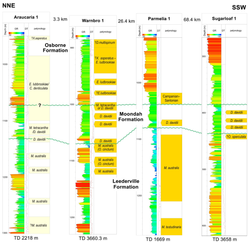
Araucaria 1 was drilled in 1993, approximately 2.5 km south southwest of Rottnest Island and 3.5 km north northwest of Warnbro 1 (Fig 1). The 1130–35 m cuttings sample contains Diconodinium davidii and the 1105–1110 m and 1120–1125 m cuttings samples contain Muderongia tetracantha. All three samples were originally placed in the Osborne Formation (Petrofina Exploration Australia S.A. 1993*). Because of heavy caving from younger strata, it is not possible to determine the exact interval that can be assigned to the Moondah Formation, but it is certainly present at, or slightly above, 1130–1135 m. The samples from 1105–1110 m and 1120–1125 m belong to the M. tetracantha or D. davidii Zones. Correlation of Warnbro 1 and Araucaria 1 is constrained by the limited number and poor quality of palynologically productive samples. One of the several possible correlations to nearby Warnbro 1 is based on the GR log and places the top of the Moondah Formation as high as 1073 m in Araucaria 1 (Fig. 5).
Parmelia 1 was drilled in 1983 approximately 26 km west southwest of Warnbro 1 and 15 km north northeast of Challenger 1 (Fig 1). The palynology in the well completion report (Crossing and Bundesen 1983*) records Diconodinium davidii and Endoceratium turneri in two SWCs, both from 1071 m. These identifications were confirmed in the review by Western Palynoservices* (1991). Of the two samples, the first is described as dark grey siltstone with minor glauconite, the second, presumably shot close to the first, is described as dark grey sandy siltstone with lenses of sandstone. The samples were originally assigned to the Osborne Formation, identified from 1025 m to 1108 m (Crossing and Bundesen 1983*). If the 1071 m SWC samples are from the Moondah Formation, then there is no palynological evidence for the Albian Osborne Formation in Parmelia 1, unless it is present between 1025 m and 1071 m. Samples from 1038 m to 1023 m are dated as Campanian to Santonian. Samples at 1092 m and below belong in the M. australis Zone, with Ovoidinium cinctum present at 1092 m, and are placed in the upper Leederville Formation.
Challenger 1 was drilled in 1975 by WAPET approximately 40 km southwest of Warnbro 1. The well completion report (Barr and Bradley 1975*) does not indicate the presence of any late Aptian strata. The review by Western Palynoservices* (1991) identifies Muderongia tetracantha in the SWC from 837 m, a sample originally assigned a Cenomanian age and placed in the Osborne Formation. The Moondah Formation may be present in in this well, possibly between 838.5 m and 848.9 m, or alternatively only the M. tetracantha Zone of early Albian age is present.
Felix 1 was drilled by Woodside Offshore Petroleum Pty Ltd in 1998, 28 km north northwest of Sugarloaf 1 on the Vasse Shelf, an upthrown fault block on the south-western margin of the Vlaming Sub-basin. The palynology report (Woodside Offshore Petroleum Pty Ltd 1998*) records the 640–650 m cuttings sample as M. australis Zone, but notes the presence of Muderongia tetracantha and suggests the M. tetracantha Zone lies between 625 m and 640 m. This could represent the D. davidii Zone or M. tetracantha Zone. The Moondah Formation may be present, but the evidence is equivocal.
Sugarloaf 1, 79 km south southwest of Warnbro 1 was drilled in 1971 in the southern part of the Vlaming Sub-basin. The well completion report (Bird and Moyes 1971*) records Muderongia tetracantha in a SWC from 413.6 m, which was dated as Albian and questionably assigned to the South Perth Formation. Western Palynoservices* (1991), recorded Diconodinium davidii at 425.8 m and the sample was assigned to the D. davidii Zone. The palynology slides from Sugarloaf 1 were reviewed for this paper and samples from 399.3 m, 413.6 m and 425.8 m were confirmed as D. davidii Zone. The Moondah Formation is present probably between 385 m and 437 m. The highest palynological sample that can be confidently placed in the Leederville Formation is from the SWC at 442 m.
COMPARISON WITH OTHER BASINS IN AUSTRALIA AND PAPUA NEW GUINEA
Late Aptian deposits containing the D. davidii Zone are widespead in marginal basins around Western Australian and in the inland basins of eastern Australia, notably the Surat and Eromanga basins. These strata are sometimes radiolarian rich and may contain shallow water foraminifers, but few macrofossils (Haig 2005). Haig and Barnbaum (1978) identified dinocysts in two outcrop nodule samples from the type section of the Wallumbilla Formation of the Surat Basin that are consistent with the D. davidii Zone though the original correlation was with Morgan’s (1980a) version of the O. operculata Zone. In the Eromanga Basin Morgan (1980a 1980b) defined several zones that Helby et al. (1987) re-organised into the current zonal scheme.
In the offshore Northern Carnarvon Basin, the D. davidii Zone is commonly encountered in petroleum exploration wells as far northwest as ODP Site 765 in the Argo Abyssal Plain (Helby and McMinn 1992). In the Southern Carnarvon Basin, the D. davidii Zone is present throughout the Windalia Radiolarite and known from many boreholes from c. 50 km south of Exmouth Gulf to east of Shark Bay. One of the best sampled sections is 98–145 m in Barrabiddy 1, which is entirely within the D. davidii Zone. Samples just above in the lower Gearle Siltstone are assigned to the M. tetracantha Zone (Backhouse in Mory and Yasin 1999). Outcrops of this unit are largely confined to the eastern margin of the basin and have yielded Aptian ammonites (Brunnschweiler, 1959). The southernmost outcrop is east of Kalbarri, where it is approximately 12 m thick (Hocking et al. 1987). To the west of the Southern Carnarvon Basin, four dredge samples obtained by Geoscience Australia from the offshore Houtman Sub-basin yielded the D. davidii Zone; another sample was assigned to the M. tetracantha Zone and nannofossils from this sample were dated as early Albian (Daniell et al. 2010*).
In the Bonaparte Basin the widely distributed but thin Darwin Formation has a radiolarian rich upper interval that Mory (1991) suggested may be correlated with the Windalia Radiolarite of the Carnarvon Basin. Campbell* (2003) indicates the Darwin Formation is late Aptian in age and immediately above the K40 regional pick of Woodside.
In the Eucla Basin east of the Yilgarn Craton, the D. davidii Zone is present in boreholes drilled for mineral exploration from close to the transcontinental railway line north of Eucla (Backhouse 2013*) and at the western margin of the Eucla Basin near Ponton Creek (Backhouse 2007*). In the South Australian part of the Eucla Basin, Morgan (1980a) records Diconodinium davidii in the borehole S.A. DM Nullarbor RDH 8. To the south of the Yilgarn Craton, in the offshore Bremer Sub-basin of the Bight Basin, four dredge samples are identified as D. davidii Zone and two as M. tetracantha Zone (Macphail and Monteil 2005*), thus confirming the presence of late Aptian and early Albian strata.
Farther afield, the early Albian EK3 and late Aptian EK4 Zones occur in the Juha Member of the Ieru Formation of the Papuan Fold Belt and other areas of Papua New Guinea (Davey 1999). These zones are the equivalent of the M. tetracantha and D. davidii Zones respectively. Davey (1999) noted a stratigraphic break at the top of EK3 and that the succeeding zone, EK2 (= C. denticulata Zone), is often absent. Another stratigraphic break and a significant change in dinoflagellate associations occur at the base of Zone EK4, which typically features a sandstone near or at its base. EK4 is consistently present and 91–152 m thick in the Papuan Fold Belt (Davey 1999). This stratigraphic succession is essentially identical to that in the Perth and Carnarvon basins.
CONCLUSIONS
The Moondah Formation can be considered as a chronostratigraphic unit as initial identification depended on biostratigraphic criteria in many locations. Follow up lithostratigraphic correlation has proved successful when sufficient sample and wireline log data has been available. The formation is differentiated from the Warnbro Group below and the Osborne Formation above on some wireline logs, and biostratigraphically by the presence of the late Aptian D. davidii Zone. Palynological boundaries at the base and top of the formation define a single discrete stratigraphic unit that correlates with the Windalia Radiolarite of the Carnarvon Basin and with stratigraphic units in onshore and offshore basins in Western Australia. It also correlates with units in the Eromanga and Surat Basins in eastern Australia and with the biostratigrphic EK4 Zone in Papua New Guinea.
Although late Aptian strata have been noted in the Perth Basin in many earlier reports, it has not been differentiated as a separate unit but instead was variously included in the underlying Leederville Formation or the overlying Osborne Formation. The zone immediately succeeding the D. davidii Zone, the M. tetracantha Zone, may be present within a very thin stratigraphic interval at the base of the overlying Osborne Formation in some boreholes. A sequence boundary probably exists between the M. tetracantha Zone and the rest of the Osborne Formation above, as is the case with the zone in the Gearle Formation in the Carnarvon Basin. This correlates with the K43 sequence boundary of Marshall and Lang (2013). These successive three sequence boundaries — at the base of the D. davidii Zone, between the D. davidii Zone and the M. tetracantha Zone and at the top of the M. tetracantha Zone — are possibly more widely present in Cretaceous successions than recognised to date.
In the southern Vlaming Sub-basin, the thickness of the Moondah Formation is unclear in most wells because of limited sampling, but is probably no more than 40–80 m. In this region the unit is poorly sampled because it lies above the Warnbro Group and has no commercial significance. Although the D. davidii Zone or a related biostratigraphic unit has been recorded previously in several reports on these offshore wells, it is placed here for the first time in a distinct sedimentary unit in that part of the basin.
In the onshore Perth Basin, the Moondah Formation has been identified along the eastern margin of the Dandaragan Trough near the Muchea Fault. The formation has also been recognised near the coast at Ledge Point, in the eastern Dandaragan Trough south of Gingin, on the coastal strip south of Mandurah and south of Busselton in the southern Perth Basin. Variations in the thickness and distribution of the unit suggest it may have been preferentially deposited or preserved on the downside of fault zones, possibly close to active north–south striking faults and associated accommodation zones, when tectonic spreading rates and reorganization of the Australia and Antarctica plates slowed during the late Aptian (Asimus et al. 2025; Bredow and Steinberger 2018; Jiang et al. 2020; Olierook et al. 2020). The formation is notably absent in the Perth metropolitan area and in parts of the central Dandaragan Trough where the Osborne Formation or younger strata unconformably overly the Warnbro Group.
References cited with an asterisk (*) are listed in APPENDIX 1: GREY-LITERATURE REFERENCES.
ACKNOWLEDGEMENTS
David Haig of the University of Western Australia unsuccessfully attempted to obtain radiolaria from four samples; he also assisted in guiding this paper to a satisfactory conclusion and his help is gratefully acknowledged. Sarah Martin (GSWA) provided considerable help with the loan of palynological slides from the GSWA collection over many years. Charmaine Thomas (GSWA) provided advice on the possibility of identifying the Moondah Formation in seismic lines. Daniel Peyrot of MGPalaeo provided help with Figure 2. The Department of Water Environment and Regulation provided data for the figures and Carolyn McMillan from that department generated Figure 1. Adam Charles of MGPalaeo is thanked for his thorough and helpful review. AJM publishes with the permission of the Director, GSWA.