_and_u_th_curves_and_ou.tiff)
INTRODUCTION
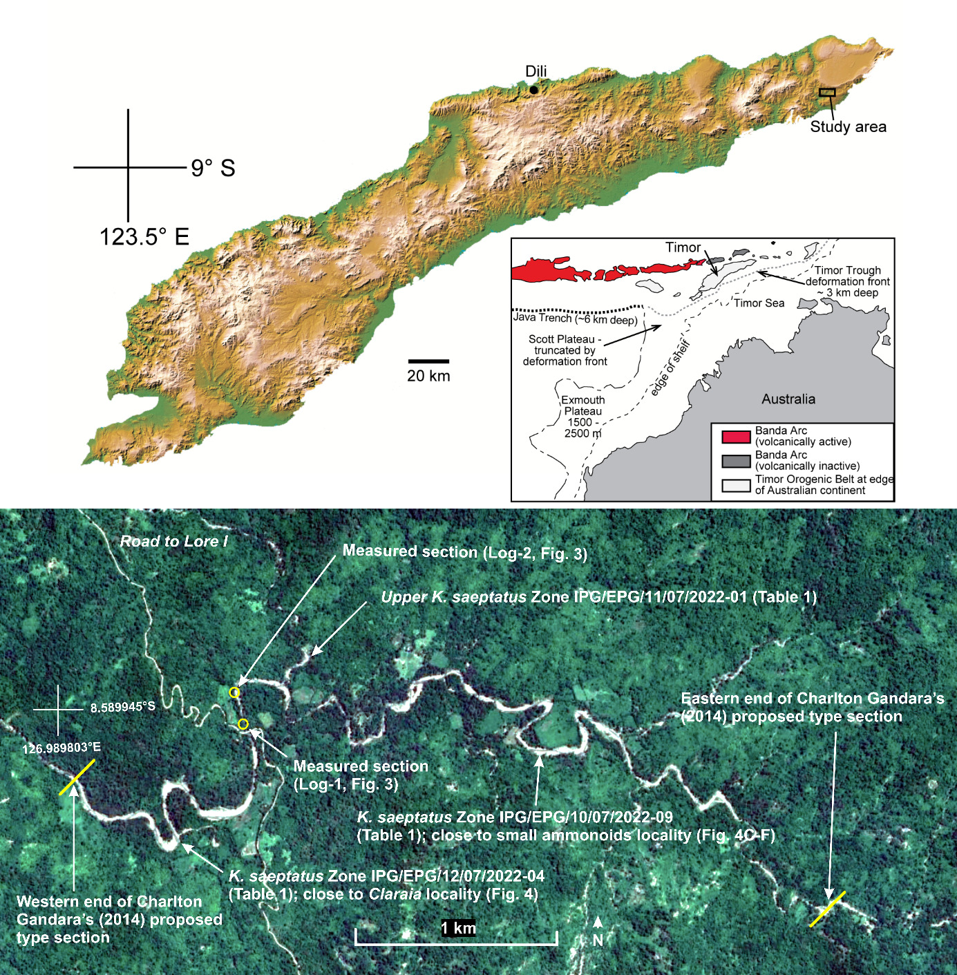
Timor Island, at the edge of the Australian continent, is part of one of the youngest and most chaotic orogenic belts in the world (Hamilton 1979; Fig. 1). This is the product of the ongoing collision between the north-west margin of the Australian continent and crustal blocks derived from Sundaland to the north. The collision was initiated between 9.8 Ma and 5.5 Ma based on the youngest pre-collision stratigraphic unit of the now deformed Australian continental margin and the oldest synorogenic deposit known in Timor (Haig and McCartain 2007, Haig 2012). Rock successions older than late Miocene are highly deformed and must be reconstructed to work out the tectonostratigraphic framework (Nano et al. 2023, Haig et al. 2024, 2025a, b).
One of the earliest geological reconnaissance studies in Timor Island was conducted by Hirschi (1907), who undertook petroleum exploration in Portuguese Timor, now Timor-Leste. His work and that of Wanner (1931), Grunau (1953), Wanner (1956), Gageonnet and Lemoine (1958), Leme (1963, 1968), Yamagiwa (1963), Nakazawa and Bando (1968) and Nogami (1968) demonstrated that Triassic–Jurassic successions were among the most prominent in the Timor-Leste sedimentary record. A comprehensive stratigraphic nomenclature with formal formation names was first applied by Audley-Charles (1968), based on his mainly reconnaissance mapping work over all of Timor-Leste. The Triassic–Jurassic nomenclature and stratal interpretations have been revised by Monteiro and Pinto (2003), Roniewicz et al. (2005), Haig et al. (2007, 2021a, b, 2024, 2025a, b), Charlton et al. (2009), Haig and McCartain (2010, 2012), Benincasa et al. (2012), Haig and Bandini (2013), Charlton and Gandara (2014), Peyrot et al. (2019, 2025), Barros et al. (2022, 2025), Scibiorski et al. (2022a, b), Nano et al. (2023), McCartain et al. (2024), and Forel et al. (2025).
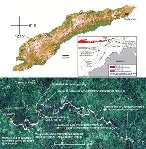
Since Timor-Leste independence in 2002, there has been a renewed effort in hydrocarbon exploration on the mainland. As part of petroleum prospectivity work, Charlton and Gandara (2014) recognised a succession of “red, grey, green and blackish shales, well laminated on a mm-cm scale with minor thin interbeds of siltstone/fine sandstone” in the Tchinver River in the eastern part of the island (Fig. 1).
Despite a lack of outcrop photographs, no stratigraphic log, and no biostratigraphic control, they named the unit the “Tchinver Shale” and proposed part of the Tchinver River as a potential type section (Fig.1). The Late Jurassic age was suggested based solely on lithological similarity with shale containing “fragments of Belemnopsis type-belemnites” in the Aliambata area about 50 km to the west. They stated that the Tchinver Shale was unfossiliferous but noted a lack of halobid/danonellid bivalves typical of the Triassic and suggested that this also supported a Late Jurassic age. Charlton and Gandara (2014) proposed that the Tchinver Shale “unconformably/disconformably” overlies the Wailuli Formation without any age control. The unit was later referred to as either the Tchinver Shale or the Tchinver Formation (Charlton et al. 2018, Charlton 2023a, b, and Munasri et al. 2024) and its position in stratigraphic charts was embedded in the Upper Jurassic: “Oxfordian to lower Tithonian” according to Charlton et al. (2018, fig. 2); “upper Oxfordian to top of Tithonian” according to Charlton (2023a, fig. 3); “Upper Jurassic to lowest Cretaceous” according to Bucknill et al. (2019, fig. 2) and Munasri et al. (2024, fig. 2); all without any direct age control for the unit.
Gageonnet and Lemoine (1958) mapped the Tchinver River as “Série de Kekneno (autochtone)”, Grunau (1953, 1957) showed it within the “Complexo Autoctono, Triásico (perto de Pualaca também Jurássico)”, Leme (1968) included it in the “flysch facies of the Série do Triásico-Jurássico”, and Audley-Charles (1968) mapped the southern part of the study area as the Aitutu Formation, while assigning the clay-dominated facies to the North as “Bobonaro Scaly Clay”.
During 2022, the Instituto do Geociências de Timor Leste-Instituto Público (IGTL-IP) remapped the area and found the presence of bivalves and ammonoids within the “type section” of the Tchinver Shale (Fig. 1). IGTL also recovered three palynological assemblages from the shale succession (two within the “type section” and another just to the north in a small tributary of the river; Fig. 1). The biostratigraphic results necessitate a major revision of the stratigraphic correlation of the shale succession exposed in the river outcrops.
The aim of this study is to describe the shale succession observed in the Tchinver River at the “type section” and provide evidence for its age. The shales are placed in the stratigraphic framework for Timor-Leste outlined in McCartain et al. (2024) and Haig et al. (2025b) and correlated to coeval units in basins of the East Gondwana Interior Rift system to the east and south of Timor-Leste.
MATERIAL AND METHODS
The study traversed along Charlton and Gandara’s (2014) potential type section on the Tchinver River and in nearby tributaries (Fig. 1), making outcrop observations of rock types, bed forms, sedimentary structures, and macrofossils. GPS locality co-ordinates were noted, structural measurements were made, and outcrop photographs were taken. Two stratigraphic sections were measured along river cliffs. Gamma-ray logs of the sections were produced, with measurements at 30 cm intervals using hand-held Radiation Solution RS-330 multipurpose gamma analyser. API values were calculated using recorded Uranium (U), Thorium (Th), and Potassium (K) values in each measured point. U/Th ratios from the measurement points were also plotted on a graph to show variation in the organic matter content within the section. Representative samples were collected and are housed in the IGTL laboratory in Dili. Three samples of dark grey shale with a kerogen smell were sent to the laboratory of MGPalaeo in Perth, Australia, for palynological analysis.
RESULTS
Shale outcrops
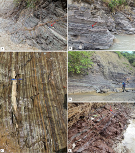
The study area has undergone intense structural deformation, with outcrop-scale folding and faulting very common. Because of the deformation and discontinuous outcrop, it is not possible to measure an overall stratigraphic section. The best rock exposures are along the riverbank, and in the upper part of the small tributary that includes palynology sample IPG/EPG/11/07/2022-01 (Fig. 1; Table 1). The main rock types found are varied-coloured shale (e.g., Fig. 2A, B) with rare thin beds to laminae of fine-grained carbonaceous lithic sandstone (e.g., Fig. 2C). Rare muddy limestone beds, no more than 10 cm thick, are also present. Matrix-supported fine to coarse polymict conglomerates, in discontinuous beds about 10-30 cm thick are present at 8.59408°S, 126.991°E in outcrop along the river. Clast size of this conglomerate varied from mm to cm in size. The affinity and age of the conglomeratic beds is uncertain. Due to discontinuity in outcrop exposures, no direct contact with a different formation was observed along the traverse during the fieldwork. However, towards the higher ground to the west, the succession is interpreted as grading upwards to the Middle to lower Upper Triassic Babulu Formation (see McCartain et al. 2024 for revised definition of this formation) but age control is needed to confirm this correlation.
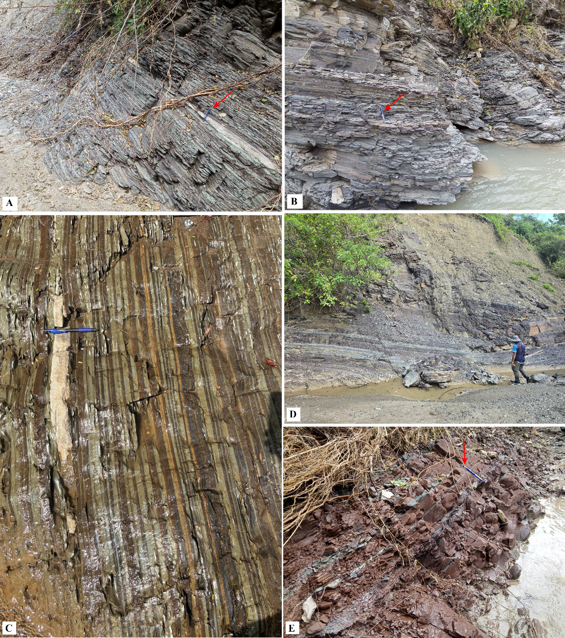
A stratigraphic section (Fig. 3A) of approximately 12 meters in thickness was logged within the study area at longitude 126.998682°S; latitude: -8.590027°E in the 2022 field season and later modified during the 2026 field season. The outcrop succession is characterized by mainly shale facies. An ~ 1.5 m interval of thin-bedded carbonaceous lithic sandstone and shale occur between 7–8.5 m, with the thin sandstone beds showing slightly irregular to straight cylindrical (? burrows, < 1 cm diameter) on bedding planes.
_and_u_th_curves_and_ou.tiff)
The Total Gamma Ray Log (in API) suggests a general fining-upwards succession at least up to 6.5 m with change in depositional cyclicity likely in this interval. What follows is probably a general coarsening upwards succession at least to 11 m.
A second stratigraphic section (Log-2, Fig. 3) of 4 m thickness was measured at 8.588234°S, 126.99798°E. The outcrop succession is mainly shale. Occasional thin bedded carbonaceous lithic sandstones, broadly lenticular, are also present in this section. Unlike Log-1, however, very little variation is observed in terms of gamma ray log values.
Biostratigraphy
Macrofossil assemblage
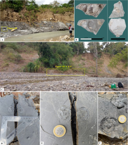
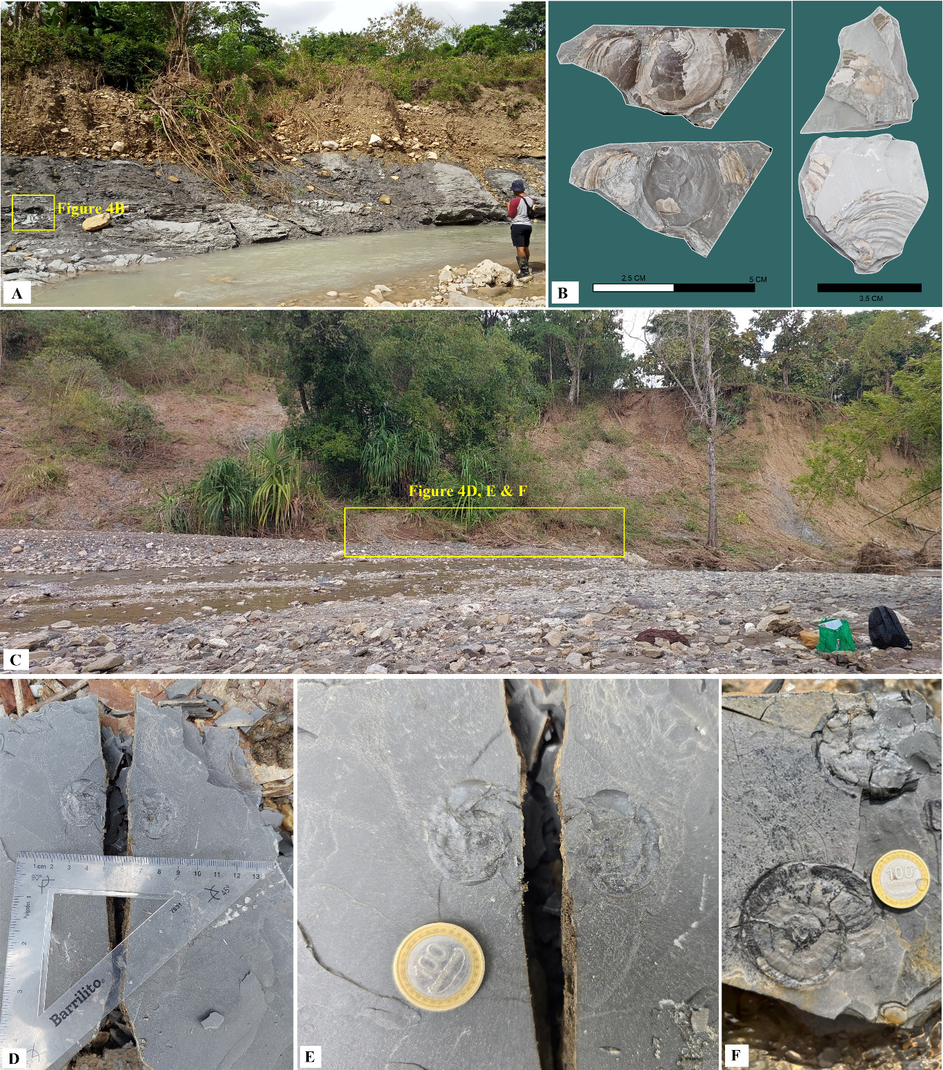
Rare thin-shelled bivalves attributed to Claraia Bittner were found in the Tchinver Shale “type section” (Fig. 4A, B). These are preserved as disarticulated valves that are thin-shelled and fragile. Most are moulds, but the remains of shell material, although probably recrystallized, are present on some of the fossils. Based on a slightly retrocrescent morphology, the left valve weakly inflated at the umbo that protrudes above the hinge, and weak concentric growth lines without radial ribs, the specimens seem close to Claraia griesbachi (Bittner) and to Claraia wangi (Patte) following He et al. (2007), Gao et al. (2009), and Huang et al. (2018). They differ from Claraia perthensis Dickins and McTavish (1963) from the Lower Triassic of the Perth Basin (see also Shi et al. 2022), in the southern part of the East Gondwana Interior Rift system, and from Claraia stachei, tentatively identified by McCartain et al. (2024) from the Baharedu beds in Timor-Leste, in lacking radial ornament. Claraia Bittner of the Lower Triassic differs from the longer ranging Posidonia Bronn by having a much longer hinge (see Fig. 4B) and fainter concentric ornament than in Posidonia (see illustration of its type species and diagnosis of the genus by Cox et al. 1969, p. N342, fig. C68, no. 5). Although the taxonomic affinities of the Claraia are clear, more precise identifications await a larger collection of these bivalves.
Ammonoids
Very rare, compressed moulds of small (< 2 cm diameter) thin-shelled ammonoids were found at two localities in the river outcrops. At one locality (8.589926°S and 127.012425°E), adjacent to K. saeptatus Zone sample IPG/EPG/10/07/2022-09 (Fig. 1), Claraia was also present. The ammonoids are planispiral and partly evolute. The shells are generally smooth with very faint radial ribbing, except for one specimen (Fig. 4F) where close-spaced fine ribbing is present on early whorls and becomes more prominent and more widely spaced on the final preserved whorl. Although the precise nature of the axial profile of the shell and the nature of the periphery is obscure and suture lines cannot be seen, the specimens are probably ophiceratids tentatively suggesting an age no younger than Dienerian (late Induan; Dai et al. 2018, Ware et al. 2018).
Palynomorphs
Palynomorphs were recorded from three outcrop samples of the Shale (Fig. 1; Table 1). The assemblages include spores and pollen of terrestrial plants as well as microplankton (acritarchs). The samples include very rare to abundant Kraeuselisporites saeptatus Balme and very rare to rare Densoisporites playfordii (Balme), as well as abundant acritarchs including Veryhachium spp. and Michrystridium spp. The spores Lundbladispora brevicula Balme, L. willmotti Balme, Protohaploxypinus samoilovhii (Jansonius) and Lunatiporites noviaulensis (Leschik) together with un-named species of Stroterosporites and Aratrisporites are present at least in one of the samples.
DISCUSSION
Age of Shale succession in upper Tchinver River
Macrofossils
The presence of Claraia with affinities to either C. griesbachi or C. wangi indicates that the shale containing these macrofossils lies within the Induan (lowest Triassic) Stage (He et al. 2007, Gao et al. 2009, Huang et al. 2018) with a chronometric range between 251.902±0.024 Ma (the Permian/Triassic boundary) and 249.9 Ma (http://www.stratigraphy.org/ICSchart/ChronostratChart2024-12.pdf). In Southwest China, Huang et al. (2018) recorded a C. griesbachi-C. wangi assemblage zone in the middle to upper Griesbachian (the lowest substage of the Induan). The probable ophiceratid ammonoids tentatively suggest an age no higher than the Dienerian in the upper Induan (Ware et al. 2018).
Palynomorphs
The palynomorph assemblages were obtained from a shale outcrop that lacked macrofossils. The presence of abundant palynomorphs dominated by Michrystridium and Veryhachium acritarchs were recovered from these samples. The assemblages (Table 1) are attributed to the Induan-lower Olenekian (Lower Triassic) Kraeuselisporites saeptatus Spore-Pollen Zone which was defined as an assemblage zone by Dolby and Balme (1976) with a type section in the Kockatea Shale of the Perth Basin.
This confirms that the shale unit at the macrofossil locality and at the three sites sampled for palynomorphs fall within the Lower Triassic and not the Upper Jurassic as suggested by Charlton and Gandara (2014). The shale succession lies within the Induan and possibly the lower Olenekian stages (i.e. the lowest Triassic; following correlations outlined by McCartain et al. 2024, fig. 3).
Depositional environment
The shale dominated succession, containing in places laminated to thin bedded very fine sandstone, suggests a low energy depositional environment. The presence of marine spiny acritarchs in the palynomorph assemblage together with Claraia bivalves indicate marine conditions. Huang et al. (2018) noted that Claraia (like a “paper pecten”) preferred mud substrates, particularly those that were apparently deposited under low oxygen conditions (i.e., dysoxic to anoxic environments) and suggested that Claraia lived in “deep-basin environments (more than 200 m depth)”. Multicoloured shale along the Tchinver River likely reflects alternating depositional environments driven by shifts in the marine redox conditions and organic matter supply. Dean and Stow (1984) proposed greyish red to purple shales formed during oxygen-rich intervals, when iron was oxidised and organic matter was largely decomposed, reflecting well-circulated bottom waters conditions. Very pale green shales represent transitional phases, deposited under fluctuating reducing conditions, with iron remaining in a reduced state, indicating partial oxygen depletion. On the other hand, black shales record episodes of anoxic conditions, with oxygen minimum zones expanded and organic matter exceptionally well preserved.
Correlation elsewhere in Timor-Leste
This study has shown that the shale-dominated succession in the Tchinver River is of Early Triassic age as opposed to the Late Jurassic age interpreted by Charlton and Gandara (2014). The succession is correlated to the Baharedu beds characterized by shale-dominated facies with intermittent fine-grained sandstone and thin calcilutite (McCartain et al. 2024). These beds are based on a type section in the Summasse River near Cribas that contains Claraia spp. and poorly preserved ammonoids of Early Triassic age. Sample C505a from the type section belongs to the Early Triassic Kraeuselisporites saeptatus Spore-Pollen Zone (McCartain et al. 2024, their table S2).
The Tchinver River succession should be mapped as Baharedu beds because of lithofacies similarity and demonstrated equivalent age range. The use of the term “Tchinver Shale” (Charlton and Gandara 2014) or “Tchinver Formation” (e.g., Charlton et al. 2018) should be discontinued because of lack of any original or subsequent age data by these authors, minimal lithostratigraphic details, and continual misalignment of its stratigraphic placement as Upper Jurassic without direct age control (e.g. by Charlton et al. 2018, Bucknill et al. 2019, Charlton 2023a, b, and Munasri et al. 2024).
Timor includes different tectonostratigraphic associations each with a different cluster of geological formations, and each deposited in a separate tectonic setting (Haig et al. 2019, 2021a, 2021b, 2024, 2025a, b, Nano et al. 2023). The Baharedu beds belong within the East Gondwana Interior Rift Association (EGIRA) as indicated by McCartain et al. (2024) and Haig et al. (2025a, b). EGIRA was deposited along a major interior rift system of basins in the eastern part of Gondwana (see Haig et al. 2025a and references therein).
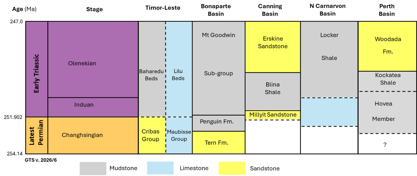
The Baharedu beds in the Tchinver River correlate, at least in part, to the Induan to lower Anisian Lilu facies of the Bandeira Formation (McCartain et al. 2024; see also Berry et al. 1984). This facies is a condensed ammonoid-rich wackestone/floatstone like in the “Hallstätt Kalk” of the Northern Calcareous Alps in Austria (see Flügel 2004, and description of the Upper Triassic Lilu facies in western Timor-Leste by Barros et al. 2022). The Lilu facies that overlies Late Permian very shallow-water limestone at the Permian-Triassic boundary section of McCartain et al. (2024) represents drowning of the shallow-water carbonate facies during the earliest Triassic. The coeval Baharedu beds in the Tchinver River may also reflect deepening of basinal water depths at this time, but more detailed study of Late Permian siliciclastic basinal facies in this region needs to be undertaken to confirm this.
Correlation within basins of the East Gondwana Interior Rift system
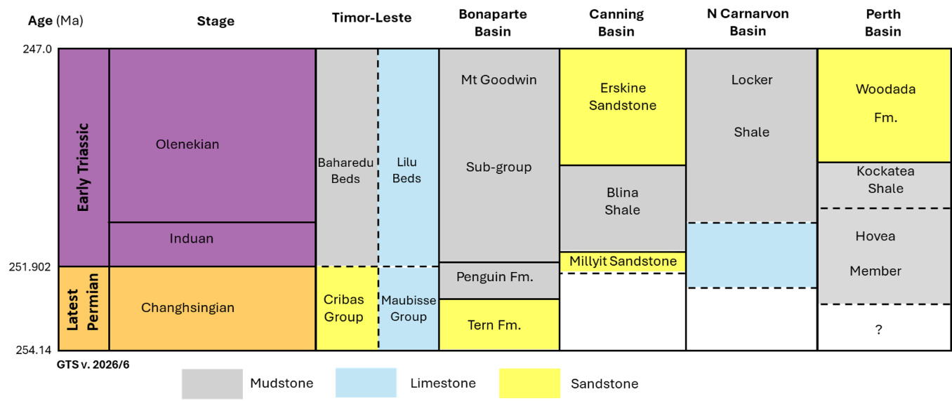
Early Triassic shale successions are widespread in basins of the East Gondwana Interior Rift system as far south as the northern Perth Basin (Fig. 5). Similar faunal and/or palynofloral assemblages to those at the studied Timor-Leste site are present in the Kockatea Shale in the northern Perth Basin (e.g., Haig et al. 2015), Locker Shale in the Northern Carnarvon Basin (Hocking et al. 1987), Blina Shale in the Canning Basin (Mory 2010), and shale within the Mt Goodwin Sub-group in the Bonaparte Basin (Gorter et al. 1998). This widespread shale facies represents a significant major marine transgression during the earliest Triassic (Marshall and Lang 2013).
CONCLUSIONS
The study highlights the importance of biostratigraphic control during geological mapping in Timor-Leste. Since shale successions may be superficially similar in terms of rock type and colour from the Permian to Quaternary in Timor-Leste, and deformation and dislocation of strata is widespread, the biogenic component of the rock should become a key reference in field stratigraphy as well as in more detailed analyses in the laboratory. A new sedimentary formation in Timor-Leste should not be established without proper age evidence from the designated type section. Our study has confirmed an Early Triassic age for the shale succession in the Tchinver River by diagnostic bivalve macrofossils as well as by palynomorphs, instead of a Late Jurassic age. The succession is placed in the Baharedu beds based on correspondence in lithofacies and age to the type section of these beds, and it fits well into the stratigraphic/facies framework of coeval formations in undeformed basins of the East Gondwana Interior Rift system to the east and south of Timor-Leste in Western Australia.
ACKNOWLEDGEMENTS
The Administrator of Lautem Municipality, the people of the Tchinver River area, and the Instituto de Geosciências de Timor-Leste are thanked for supporting this work. Thanks are also given to geologists Joanico Pires and Gregorio da Costa Ribeiro for helping during the 2022 field work. MGPALAEO is thanked for undertaking the palynological analyses. Two anonymous reviewers are thanked for enhancing the quality of the original manuscript.