INTRODUCTION
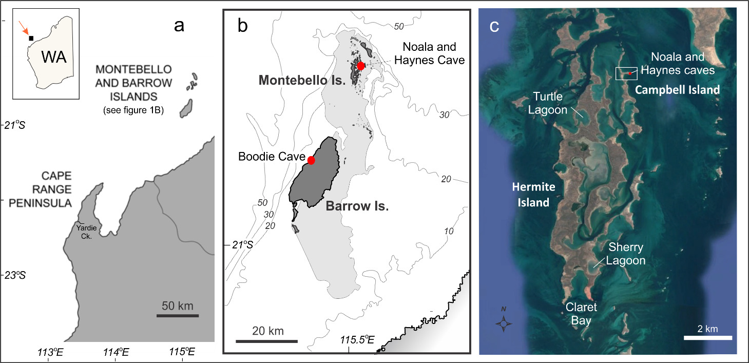
Quartz-rich sand terrains are ubiquitous throughout Australia, from the central deserts and northern arid zone through to coastal margins (Newsome and Ladd 1999) and offshore, particularly along the east coast (Short 2010). Quartz grains are relatively resistant to weathering, and their unique crystal structure and absence of cleavage allows them to record evidence of long-term sedimentary processes in the form of surface microtextural features, akin to knapping scars on artefacts (Mahaney 2002), that can be imaged via Scanning Electron Microscopy (SEM). Many archaeological sites in Australia also exist in sandy contexts, and different types of scarring on quartz grains can provide information on transportation history and depositional environment. SEM grain surface textural analysis is widely used in geology (e.g., review articles by Krinsley and Doornkamp 1973, Vos et al. 2014, Hanson and Burns 2022) but only rarely in archaeological investigations (Tankard 1974). This pilot study explores the use of quartz surface microtextural features to characterise past and present depositional contexts of archaeological rockshelter and adjacent lagoon sediments from Barrow Island and the Montebello Islands in NW Australia (Fig. 1). Our main questions are whether quartz-grain microtextures from this ancient coastal environment reflect their modern depositional context and how well the microtextures of buried grains reflect or conform to the published record of coastal change over the ~ 50,000 year record of human occupation in these islands (Veth et al. 2017).
Setting and Study sites
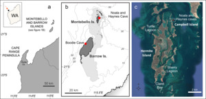
Barrow Island is situated ~ 60 km off the north-west coast of mainland Western Australia, and ~50 km from the inner continental shelf edge (Fig. 1A). As Western Australia’s second largest island (202 km2) Barrow Island encompasses a range of environments: limestone uplands, near coastal lowlands, coastal fringe, and intertidal platforms (Moro et al. 2013). The nearby (16 km) archipelago of the Montebello Islands comprises 15 N-S trending islands and 170 islets that at times of lower sea level defined the coastal margin of the inner continental shelf (Fig. 1B; see also Lebrec et al. 2022). The Montebello archipelago today includes of a mix of Quaternary calcarenitic limestone islands, barrier and fringing reefs, lagoons (some with mangroves) and intertidal embayments (Department of Environment and Conservation, 2017). During lower sea levels, the Barrow and less elevated Montebello Islands formed high points on an extensive coastal plain (Burbidge et al. 2000; Veth et al. 2007). The islands were later isolated from the mainland around 7,000 years ago by post-glacial sea level rise (Veth et al. 2007; Ward et al. 2022).
Northwestern Australia experiences extreme climatic and oceanographic conditions, with the occasional impact of severe tropical cyclones. The climate is characterised as arid and sub-tropical, with warm temperatures ranging from 24°C to 35°C throughout the year (Burbidge et al. 2000). Rainfall is generally low (~ 200 mm/yr) and unpredictable, largely influenced by the passage of cyclones. The region is tide-dominated with semi-diurnal tides with a maximum range of just over 3 m at spring tides. Whilst there is no single driver of change (Larcombe et al. 2018), large tides and cyclone-induced waves are capable of eroding sedimentary coastal features over short time frames, limited only by the underlying or abutting geological framework. Readers are referred to the cited texts above for further details of the past and present Barrow and Montebello Island environmental context.
Recent geoarchaeological field trips to Barrow and Montebello Islands were undertaken in 2020–2022, focusing on lagoon and rockshelter contexts, respectively, as well as range of modern settings as part of a larger project by Ward to characterise Holocene and Pleistocene deposits in embayments on the Montebello Islands. The lagoons with narrow (< 20 m) openings are a distinct geomorphic feature within the archipelago (Fig. 1C), and with the potential to be long-term net sediment traps were targeted for coring. This paper focuses on cores collected (by IW) from Sherry Lagoon (SH-01, 3.5 m long), Turtle Lagoon (TB-02, 3.7 m long) and from fringing mangroves within Claret Bay (CT-01, 2.7 m long) as part of a larger study of Post-Glacial palaeoenvironmental change within the Montebello Islands to be published separately
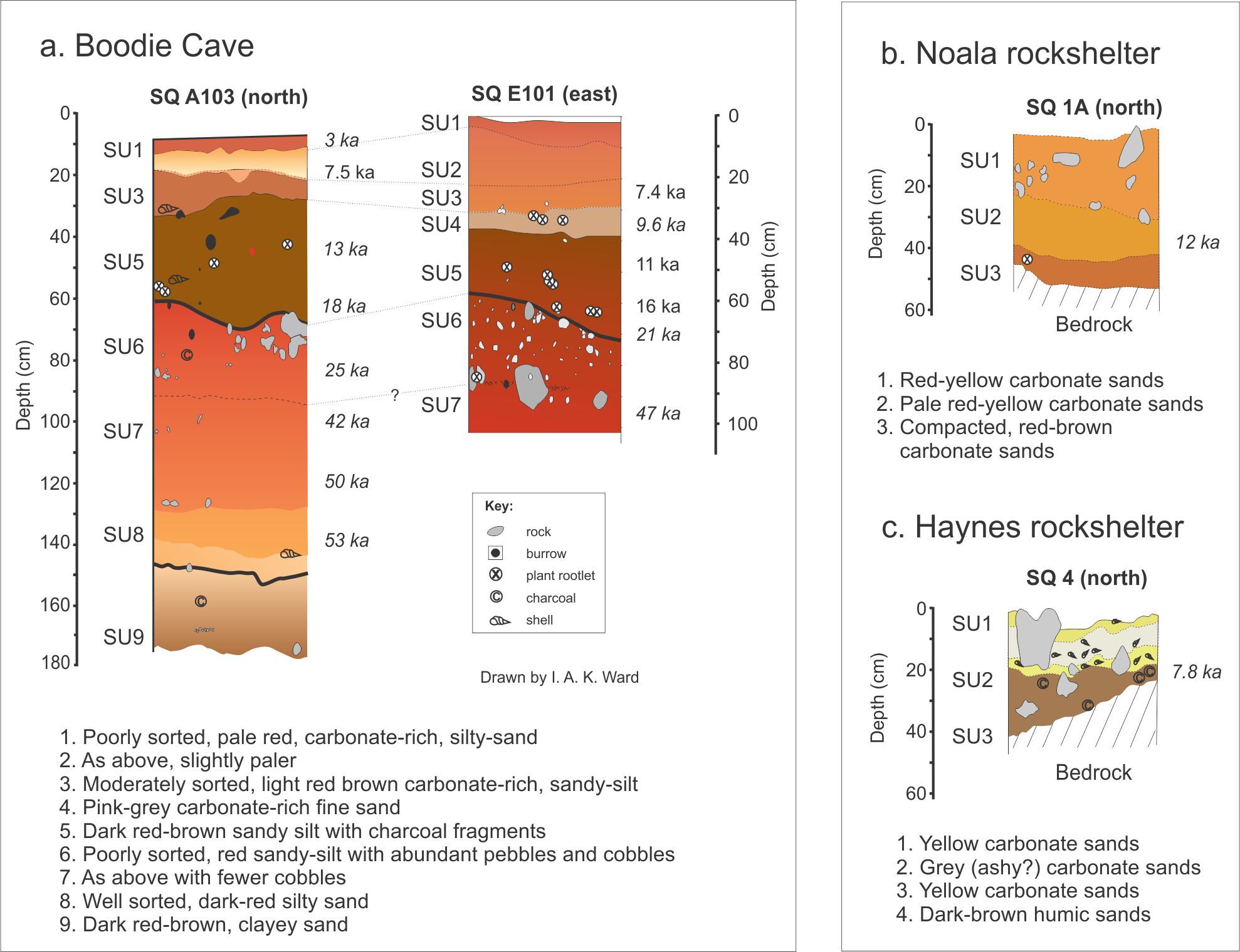
Boodie Cave (> 3000 m2) is a limestone cave located on the northwest (seaward) side of Barrow Island and ~22 m above mean sea-level (MSL). The cave was excavated between 2013–2015 as part of the Barrow Island Archaeology Project (BIAP) to a maximum depth of ~ 3 m, to reveal archaeological and zooarchaeological deposits extending back to ~ 50 ka (Veth et al. 2017). Both the zooarchaeological remains and the cave sediments show an increase in culturally-derived marine fauna and marine-derived sediments (increasing biogenic sands), particularly from 12 ka as rising sea levels were encroaching the islands (Ward et al. 2017; 2018).
The much smaller rockshelters in the Montebello Islands are clustered together on a < 1 km long E-W trending limestone peninsula on the eastern side of Campbell Island (Fig. 1C) and are likely old island flank-margin sea caves. The shallow (< 50 cm) deposits in Noala and Haynes rockshelter were excavated in the early 1990s and, as with Boodie Cave, found to be rich in cultural and zooarchaeological remains (Veth 1993; Veth et al. 2007). Noala (~ 10 m2) and Haynes rockshelters (> 100 m2) lie on the northern and southern side of the peninsula respectively. Noala rockshelter sits 5–7 m above high-water mark (HWM) and 30 m from the shore, with several large boulders partly obscuring the mouth of the cave (Veth et al. 2007). Haynes rockshelter sits 3–4 m above HWM, and 15 m from the shoreline and is also protected by large dislodged boulders, although with a relatively open entrance to the east. The most reliable age estimates for the cave deposits are from ~ 12 ka, when Post-Glacial sea levels were first encroaching the islands (Ingrid Ward et al. studies in progress, July 2026). Comprehensive descriptions of these cave excavations are given by Veth et al. (2007) and Manne and Veth (2015).
DATASETS AND METHODS
Regional Dataset
To evaluate grain microtextures from stratified lagoon, cave and rockshelter sediments, it was necessary to create a regional dataset from contemporary depositional contexts within the Montebello and Barrow Island complex (Table 1). Although the surface texture and shape of quartz grains exhibit resistance to post-depositional alteration for a considerable span, up to 8000 years according to Pye and Mazzullo (1994), there remains an inherent assumption that the reference grains are shaped in, or near, the environment in which they were collected. This assumption is intricately tied to the residence time of grains, influenced by the interplay of physical constraints, such as compartmentalization, and sediment supply, as expounded by Stul et al. (2014). Grains in short ephemeral tidal creeks of the Pilbara, for example, may bear the imprint of seasonal flash flooding events on grains inherited from outside the creek depositional context. Conversely, grains that are contained within a cave, rocky headland or protected lagoon likely have more limited exogenous input and a longer residence time. Independent 210Pb studies indicate significant local reworking within the lagoons and mangroves of the Montebello Islands over decades or a century (M. Hoffman, pers. comm. 2023).
The determination of factors such as degree of inheritance or residence time remains beyond the scope of this pilot study. It does, however, raise a fundamental question regarding how these reference grains genuinely mirror their contemporary depositional context. Within the confines of this study, a simplifying assumption is that cave sediments from Haynes rockshelter derive from wall-spall, reflecting a bedrock source and the lowest degree of textural maturity. Conversely grains from coastal creek, coastal dune, beach, intertidal and subtidal settings are posited to reflect greater textural maturity through transport by fluvial, aeolian, coastal and marine processes or a combination of these (see also Ward et al. 2022). Representative storm grains are derived from an indurated sedimentary breccia deposit located on the west coast of Barrow Island.
Lagoon sediments
For the lagoon core sediments, samples were aimed at encompassing the main lithologies that included organic and quartz-rich mangrove sands, shelly (biogenic) sands, grey calcareous (non-biogenic) silty sands, and red calcareous (non-biogenic) silty sands, all with authigenic phases from ambient fluids. These deposits are inferred to represent older terrestrial to intertidal deposits. Claret Bay (CT-01) was the only core from a mangrove setting, with sediments comprising mottled pink to brown, well-sorted, quartz-rich (< 80%) sandy peat becoming increasingly darker and more acidic (pH 4 – 4.5) with depth. The core from Sherry Lagoon (SH-01) was the only one to include a base of pale to bright red calcareous (non-biogenic) silty sands and limestone (rudstone) gravel. The quartz content of these red calcareous sediments was around 30% but less than 15% in the overlying grey calcareous silty-sand and shelly sand units. A comprehensive analysis of these marine core sediments and their chronology is part of the broader study by Ward, with initial dates providing a chronology from > 20 ka to present.
Cave and rockshelter sediments
For Boodie Cave, archival sediments from wall samples (collected by IW) were selected from six – specifically SU1, 4, 5, 6, 8 and 9, of the nine stratigraphic units (SUs) in Boodie Cave (from two excavation squares) to encompass the 50,000 year record of change (Fig. 2A). The SU numbers increase with depth and hence age. The cave sediments comprise poor to moderately sorted, medium to very coarse carbonate sands, with quartz increasing from < 5% to > 20% with depth in the profile (Ward et al. 2018). Sediment samples for Noala and Hayne’s rockshelters (Fig. 2B and C respectively) were selected from archived bulk sediments (collected by Peter Veth) from the initial excavations in the 1990’s (refer Veth et al. 2007). Sediments were taken from alternate arbitrary excavation units (spits), giving a total of six from Noala rockshelter and five from Haynes rockshelter. Spit results were then summarised per stratigraphic unit (SU), with the latter inferred from average spit depths (3 cm) and section drawings provided in Veth et al. (2007). The average quartz content for Noala and Haynes rockshelter sediments was < 25% and 10% respectively.
_within_a._boodie_cave_(modified_f.jpg)
Quartz grains were extracted from studied samples by digestion in dilute hydrochloric acid (HCl) and then rinsed in water following a modified method after Vos et al. (2014). Isolated quartz grains are set onto a ‘stub’ using double-sided carbon tape and then coated with a ~25 nanometre thin carbon layer to prevent charging. On average, images of between 15-20 individual grains per sample were taken using a Neoscope SEM housed at the Centre for Microscopy, Characterisation and Analysis (CMCA) at UWA. SEM images were analysed and compared with features from reference guides (Krinsley and Doornkamp 1973; Mahaney 2002; Vos et al. 2014). The number of individual grains that present a particular grain microtexture within the analysed grain population were documented. The occurrences were then translated into a nominal frequency or relative percentage: abundant (>70%), common (30% - 70%), sparse (5% - 30%) and rare or absent (<5%), or in the case of the lagoon sediments, averaged across the four main lithologies.
Nomenclature used here follows the grain surface microtextural classification scheme of Vos et al. (2014) that includes both mechanical and chemical microtextures. In the samples studied here mechanical microtextures include: bulbous edges (bb), conchoidal fractures (cf, < or > 100 µm), v-shaped percussion marks (vs), straight/curved grooves and scratches (sgs/cgs), arcuate/straight steps (ss), and crescentic percussion marks (cp). Chemical microtextures observed include oriented etch pits (ep), precipitated (silica) (pp) or adhering particles (ap), and holes (sp) and furrows (sc) of dissolution (after Vos et al. 2014). Added to the features list are what we termed a “remnant trough (rt)”, equivalent to the ‘dish-shaped depressions’ of Pye and Tsoar (2009), that are described as a ‘smoothed over depression face or trough with a shallow, concave appearance’ (e.g., see aeolian dune, Fig. 3). These are likely older conchoidal fractures that have been smoothed and rounded. Frosting was also recorded from visual analysis under plain light. Grain relief is also recorded and here relates to how low or high is the micro-textural topography (height difference on grain surfaces). Examples of these features are provided in the Supplementary Information.
According to Costa et al. (2012) at least five microtextural features should be considered to help determine likely sedimentary environment. The most useful features to differentiate marine or terrestrial material include (1) grain shape, (2) presence of percussion marks and fresh surfaces (conchoidal features), (3) V-shaped percussion cracks, (4) oriented etch pits, and (5) precipitated/adhering particles. However, this is complicated where source material is continuously recycled and overprinting of textures may occur. Principal Component Analysis (PCA), using the Excel addin XLSTAT (Addinsoft 2023), was undertaken to compare grains from the lagoon, cave and rockshelter settings against the reference grains with results presented below.
RESULTS AND INTERPRETATION
Regional Dataset
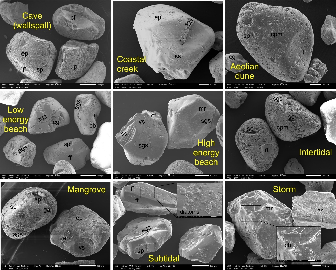
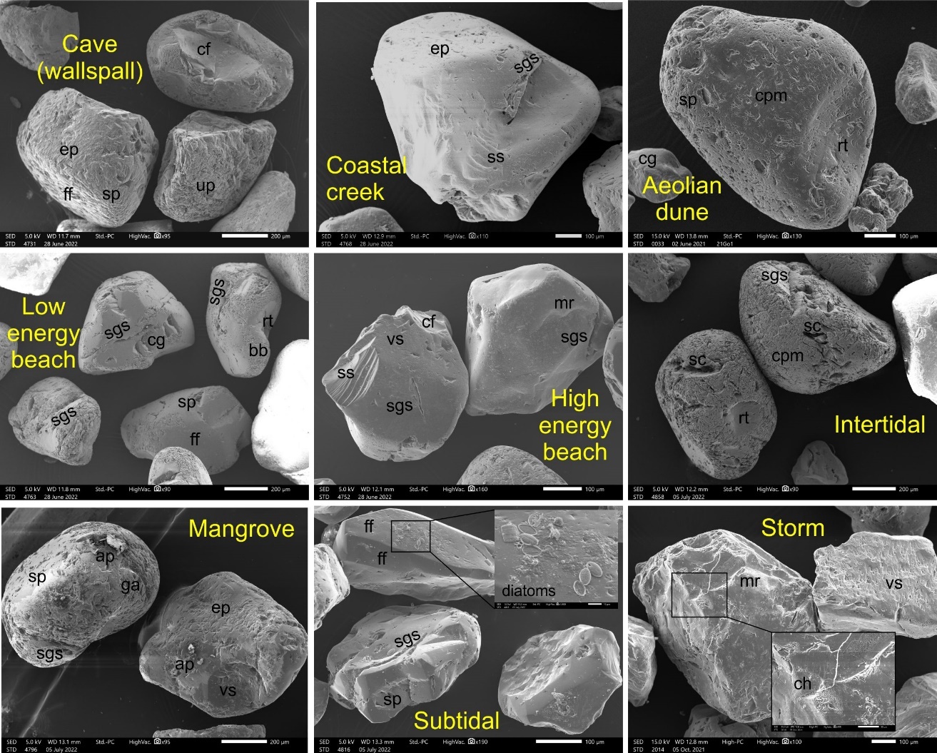
Quartz grains are described here from a terrestrial to marine context (Fig. 3 shows representative grains from the different environmental settings; refer also to Supplementary Information for close-up images of grain surface features). Grains from the cave walls have a matt appearance and comprise both subangular (50%) and rounded (50%) grains, of relatively equal proportions of low to high relief (Table 2). Mechanical microtextures dominated and include straight/curved grooves and scratches (69%), upturned plates (56%), crescentic percussion marks (44%) and remnant troughs (31%), with a high proportion of adhering particles (44%).
Grains from the coastal creek comprise fairly similar proportions of sub-rounded (47%) to rounded (35%) grains but generally of low (65%) to medium (35%) relief and with a matt appearance. Over 50% of coastal creek samples featured conchoidal fractures – both large (35%) and small (29%) and adhering particles (59%). Aeolian dune sediments are similarly frosted (matt) and comprise roughly equal proportions of rounded (35%) and subangular (41%) grains but also with significant percentage of angular grains (24%), and mostly of medium (53%) to low (35%) relief. The grain microtextures feature a high proportion of v-shaped percussion marks (47%), straight grooves and scratches (47%), meandering ridges (35%), and orientated etch pits (35%) that have been partially smoothed over.
Grains from both low and high-energy beach environments exhibit both chemical and mechanical microfeatures. Lower energy beach sands have a higher proportion of sub-rounded (60%) to rounded grains, the majority of medium relief (73%) with straight/curved grooves and scratches (67%), crescentic percussion marks (67%) and remnant troughs (47%) indicating less transport and reworking (Table 2). Samples from the high-energy beach comprised sub-rounded to rounded grains but also angular grains (13%) and included features such as v-shaped percussion marks (40%), meandering ridges (20%), graded arcs (20%), arcuate (20%) and straight steps (33%) that were largely absent in the low-energy beach. Over 80% of grains from the high-energy beach are polished (shiny).
Intertidal and mangrove environments within the Montebello Islands tend to be relatively protected. The two environments share similar microtextural features such as sub-rounded (53 – 57%) to rounded (40–43%) outlines, straight curves and grooves (60–73%), large (> 100 µm) conchoidal fractures (40–47%) with a few having remnant troughs (10–13%). Most grains have a semi-matt appearance. Where they differ most is in the abundance of orientated etch pits (60%), adhering particles (53%) and silica growth/precipitation (40%) in the mangroves, and abundance of solution crevasses (81%), crescentic percussion marks (67%) and slightly higher proportion of high relief grains (24%) in the intertidal setting.
The subtidal samples are indicative of a higher energy environment with 95% of all grains falling into the sub-rounded to angular category but with equal proportions of low and medium relief grains, and all grains are polished (Table 2). They differ from intertidal sands having a higher proportion of grains with solution pits (55%), small (< 100 µm) conchoidal factures (45%), v-shaped percussion cracks (45%), flat cleavage surfaces (30%), crystalline (mainly gypsum) overgrowth (40%) and encrustation by diatoms (45%). Diatoms are unlikely to preserve over time, hence are not expected in the archaeological sediments.
Lagoon sediments
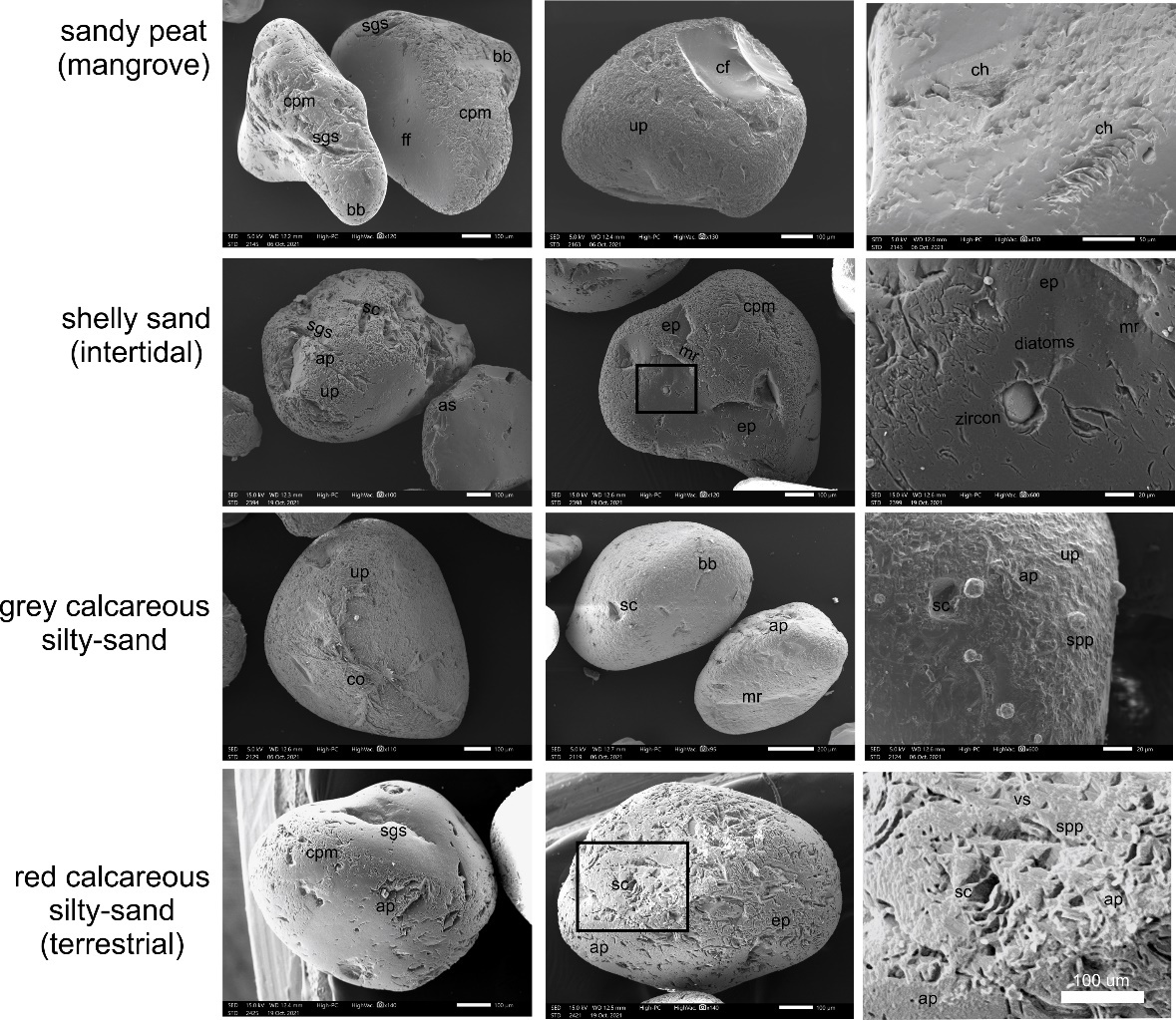
Grains are here described from the basal red calcareous silty sands in the Sherry Lagoon core, through the overlying grey calcareous silty sands and shelly sands in the Sherry and Turtle Lagoon core, and for Claret Bay, the sandy peats. Grains from the red silty sands, are similar to the open lagoon non-biogenic carbonate sands that overlie them, albeit with a higher percentage of rounded (65%), medium relief grains (45%), with straight grooves and scratches (60%), crescentic percussion marks (65%), conchoidal factures (35%), solution pits (35%), bulbous edges (35%), orientated etch pits (15%), with evident abrasion fatigue (15%) (Table 3). All have a matt appearance, with many quartz grains coated with secondary carbonate. Grains from the overlying grey unit are sub-round to rounded, of comparatively low relief, with abundant upturned plates (65%), giving a frosted (matt) appearance, and adhering particles (39%) (Fig. 4). There are relatively equal quantities of frosted and shiny grains, with the latter more common in the smaller (< 200 µm) grain fraction.
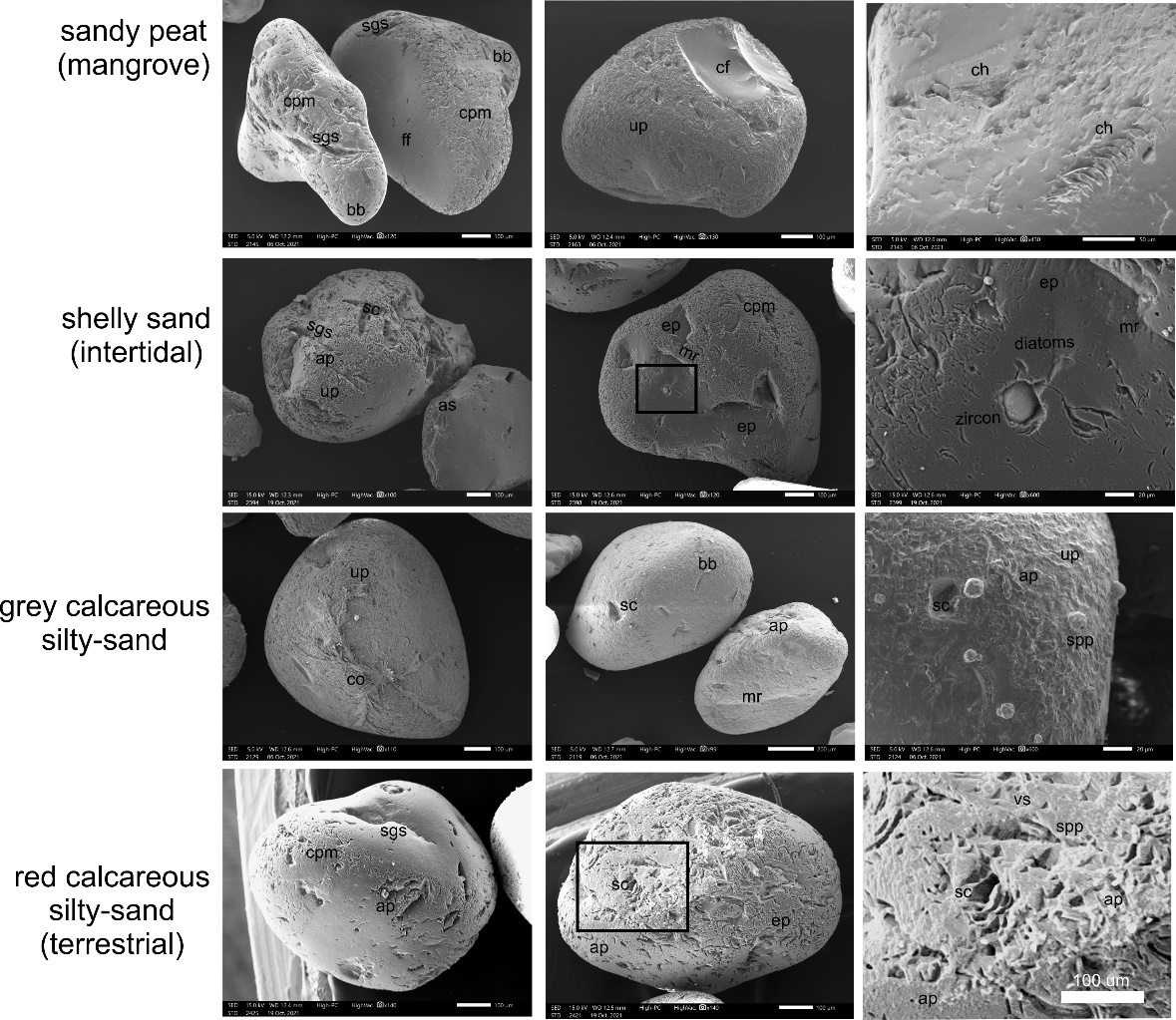
In both the Sherry and Turtle Lagoon profiles, these non-biogenic sands are overlain by shelly biogenic sands. Abundant to common in these shelly sands are rounded to subrounded, predominantly medium relief quartz grains (63%) with upturned plates (70%), straight and curved grooves (53%), crescentic percussion marks (43%, especially Sherry Lagoon), and solution pits and crevasses (30%, especially Turtle Lagoon). Flat cleavage surfaces are also common (30%) but these are generally antecedent features that have various superimposed microtextures.
The organic mangrove sediments comprise mainly sub-rounded grains (67%), almost all of medium relief (88%) and mainly frosted (matt), with shiny grains more common in the finer (250 µm) fraction. Flat cleavage surfaces are common (36%) along with bulbous edges (48%), but as for other lithologies, these are predominantly relict features (Fig. 4). Conversely conchoidal fractures (12%) and chattermarks are sparse (6%) but reflect high-energy impact, particularly in the younger (shallower) part of the profile. Abundant microtextures include straight/curved grooves and scratches (79%), crescentic percussion marks (76%) and upturned plates (67%) all of which have been enhanced by dissolution. Silica growth/precipitation is obvious on some fresh cleavage faces and rare diatoms are protected within crevasses or depressions.
Results from PCA indicate that the grains from the red and grey non-biogenic silty sands and shelly biogenic sands share most similarities with the modern cave reference samples, whilst the mangrove peats are most like a low-energy modern beach (Table 4). This may reflect the common coastal limestone origin of grains and preservation of relict features, in a protected and largely low-energy, littoral lagoon setting where all the cores were taken. Individual grain observations imply a more nuanced picture, with fewer chemical features in the grey silty sand deposits and variable aeolian contribution in all lithologies that is perhaps masked by the averaging of results.
Cave and rockshelter sediments
Boodie Cave
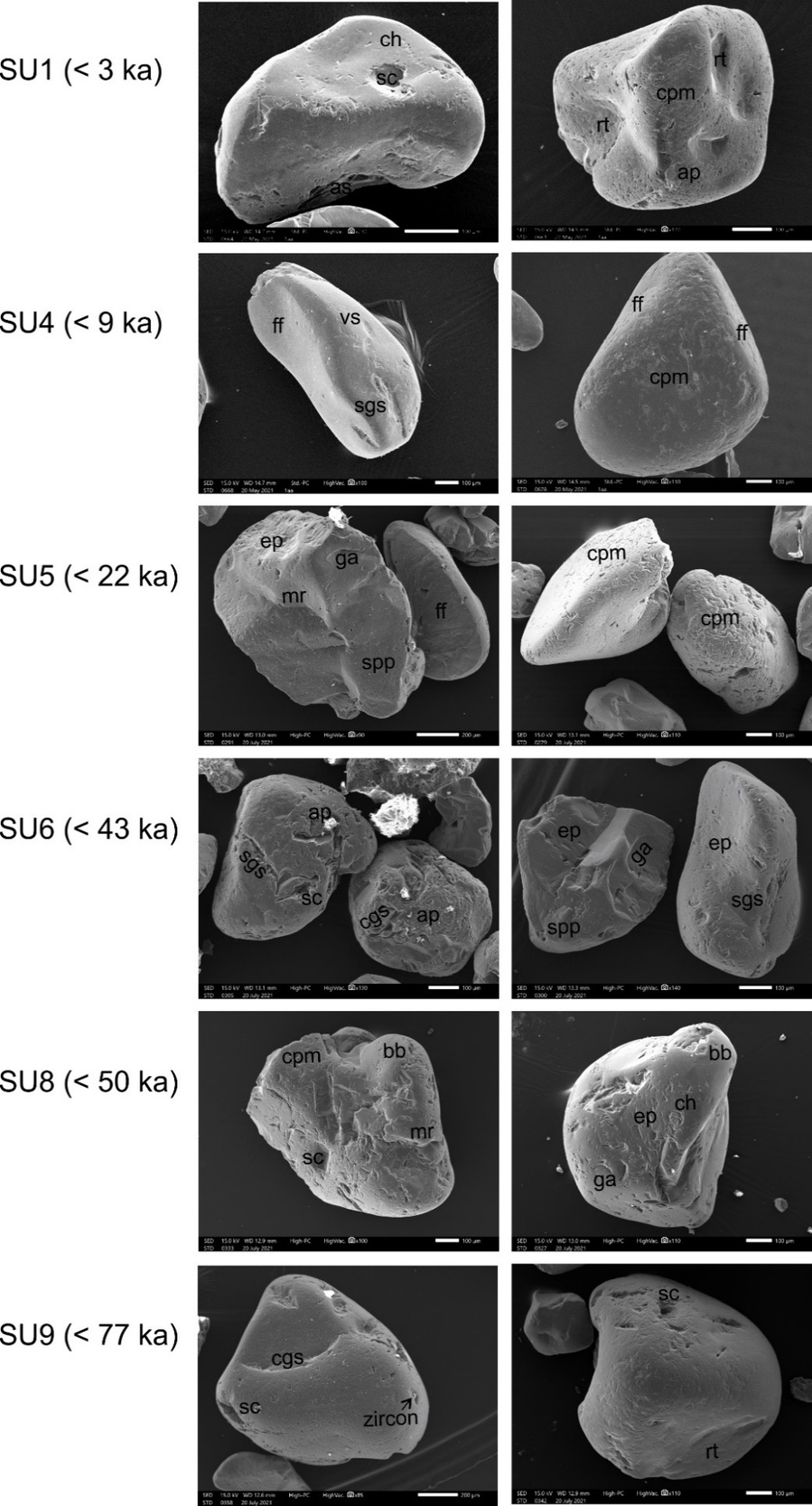
Grains from the oldest, unoccupied part of the Boodie Cave sequence (SU9) comprise relatively equal proportions of angular to rounded grains of which over half are of low relief (52%) and polished (Fig. 5). Adhering particles are common (48%) but otherwise the grains have minimal similar features to quartz grains in the overlying units (Table 5). Most grains in SU8, representing the earliest occupied layer, are mainly subrounded (75%) with crescentic percussion marks (69%). About half the grains are of medium relief (56%), have straight/curved grooves and scratches (50%) and have a matt appearance. Bulbous edges (38%), v-shaped percussion cracks (38%), oriented etch pits (38%) and solution pits and crevasses (31%) are common (Table 5).
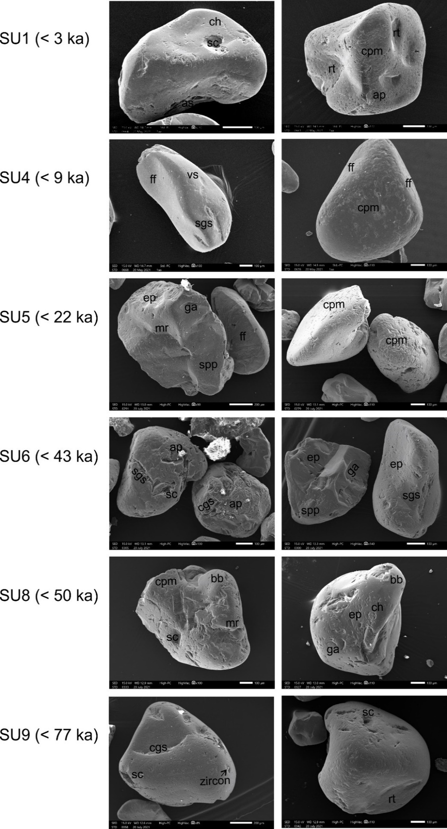
SU7 comprises both polished and matt grains but with a sparse but not insignificant proportion of angular (20%) and high-relief grains (17%), and in particular grains with v-shaped percussion cracks (75%), conchoidal factures (40%) and arcuate steps (25%). Grains in SU7 have the highest proportion of meandering ridges (40%), with upturned plates (20%) indicative of an aeolian contribution (Krinsley and Doornkamp 1973). Grains in SU6 have similar microtextural features to those in SU8, albeit with a higher proportion of grains with meandering ridges, graded arcs and straight steps (27% respectively) and polished grains (~ 80%) that imply a greater aeolian contribution (Krinsley and Doornkamp 1973). In both SU6 and SU5, flat surfaces are also common (~26%) but are an inherited feature that has been overprinted with mechanical and chemical features, and with a significant proportion of adhering particles (~48%). Grains in SU5 range from angular to rounded and generally of medium to low relief (Table 5) and semi-polished to matt (Fig. 5). Grains in this unit maintain some level of likely aeolian origin in the form of conchoidal fractures, albeit mainly small (< 100 µm, 39%), v-shaped percussion cracks (39%) and upturned plates (30%) but with evident chemical overprinting, particularly solution crevasses (35%).
SU4 has the highest proportion of low-relief grains (50%) with 45% of medium relief (Table 5). Straight grooves and scratches (55%), v-shaped cracks (45%) are common and solution crevasses are sparse to common (25%). They are equally rounded to sub-rounded (40% respectively) and variably polished or matt under plain light. Overlying this unit, grains from SU3/2 are mainly subrounded (69%) and semi-polished to matt, over a third of which have remnant troughs (37%). High-relief grains (16%) are common, many with upturned plates (37%), straight/curved grooves and scratches (32%), bulbous edges (32%), large conchoidal fractures (> 100 µm, 21%) and meandering ridges (21%). Chemical features are also present and include solution pits (26%) and crevasses (26%). Adhering particles are abundant (95%), although there is considerable uncertainty as to whether or not this is a result of sample preparation. In contrast, the uppermost unit, SU1, tend to be semi-polished and rounded (40%) but with sparse mechanical and chemical features throughout (Table 5).
PCA indicates the cave sediments generally reflect low-energy environments, with the exception of SU4 and SU7 that respectively correlate most strongly with the high-energy beach and aeolian dune references (Table 6). Both SU8 and SU6 correlate to the low-energy beach reference, SU9, SU5 and SU2/3 to the coastal (ephemeral) creek reference, and only SU1 to the cave reference (Table 6). Similar to the lagoon sediments, this bias towards cave and coastal creek references may reflect a high autochthonous contribution, whilst for SU7 and SU4, grains may reflect a greater allochthonous contribution at these different time periods.
Noala and Haynes rockshelters
The grains from Noala rockshelter are primarily rounded to subrounded and of low to medium relief, with the notable exception of grains from Spit 9 (SU 3/4) in Haynes rockshelter that include a very high percentage of angular (47%), high-relief grains (47%) and polished grains (Table 7). The grains from the uppermost unit in Noala rockshelter (SU 1) have a relative higher proportion of medium relief grains than the underlying units. Straight/curved grooves and scratches (43%), bulbous edges (41%), upturned plates (34%), meandering ridges (31%) are common and collectively indicative of likely aeolian derivation (Krinsley and Doornkamp 1973). These are overprinted by chemical features including solution crevasses (37%), solution pits (24%) and orientated etch pits (21%) that enhance V-shaped percussion cracks (31%).
Grains in the underlying units are very similar, with those from SU2 distinguished by far fewer v-shaped percussion cracks (14%) but more solution pits (43%) and evident silica precipitation (29%); and those from SU3 by more sparse meandering ridges (11%), more common small (< 100 µm) conchoidal fractures (17%) and crystalline overgrowth (12%), mainly in the form of gypsum. Although not absolute, the general trend is towards increasing chemical features in underlying units.
The grains from Haynes rockshelter comprise a broader mix of angular to rounded grains of medium relief (40 – 60%), and greater overall predominance of mechanical over chemical features (Table 7). Grains from the top of the profile (SU2) are not dissimilar to those at the top of Noala rockshelter, being mainly rounded (52) and with straight/curved grooves and scratches (36%), bulbous edges (39%), upturned plates (41%), v-shaped percussion cracks (36%) and meandering ridges (28%). Chemical features, including solution crevasses (42%) and solution pits (38%) are also common. In contrast, there is a significantly high proportion of grains in SU3/4 (Spit 9) that are angular (47%), high-relief (47%), with conchoidal fractures both small (<100 µm, 33%) and large (> 100 µm, 13%), straight steps (53%), and comparatively fresh as opposed to fossil (smoothed) flat cleavage surfaces (47%), with orientated etch pits common to abundant (67%). These features align best to the storm reference grains. Grains from the base of the profile (SU4) have a matt or semi-matt appearance and are characterised by a higher proportion of grains with straight/curved grooves and scratches (55%), many of which have been enhanced through chemical processes to form solution crevasses (35%) but much more sparse orientated etch pits (8%). The dataset does not closely align to one environment but has both aeolian and creek microtextures.
As for the Boodie Cave sediments, PCA indicates a very strong correlation with cave and coastal creek references in both Noala and Haynes rockshelters indicated a significant autochthonous contribution to these cave sediments (Tables 7 and 8). The exception is SU3/4 in Haynes rockshelter, that are consistent with a relatively strong tsunami/storm signature.
DISCUSSION
How well does the regional dataset reflect their modern depositional context
The Pilbara coast is an inherited coast, with an ancient hardrock terrain overlain or abutted by coastal and alluvial to colluvial sediments that in places have been lithified, including a high proportion of coastal limestone (Semeniuk 1993, 1996). Coastal and marine sediments reflect a high degree of reworking, evidenced from degraded and recycled Quaternary material; commonly > 80% of the samples are carbonate grains and the more resistant quartz grains likely represent reworked second or third-cycle clasts. The assemblage of mechanical and chemical surface features on grains from the Barrow and Montebello Islands show overlap as would be expected in a semi-arid, coastal-marine system where sediment is readily recycled between markedly different environments (Abd-Alla 1991). This does, however, complicate interpretations of surface microtextural features of grains from archaeological and adjacent sites.
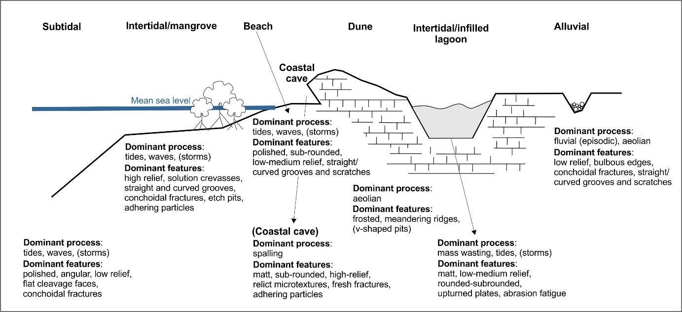
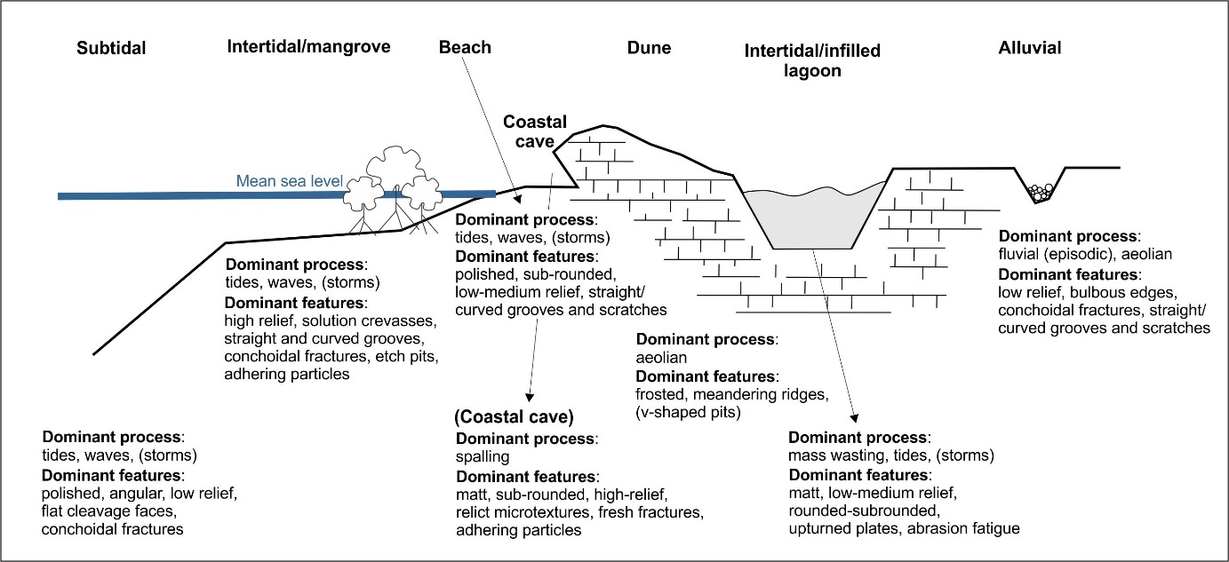
Several authors (Krinsley and Donahue 1968; Vos et al. 2014; Mahaney 2002) identify representative quartz-grain-surface microforms common to aeolian, colluvial and fluvial (and glacial) environments but acknowledge that these represent the ideal. The majority of modern reference grains loosely conform to the ‘ideal’ and have sufficient features (notwithstanding some overprinting) to be able to distinguish between the environments, particularly high energy (e.g., subtidal, high-energy beach, aeolian) and lower energy (mangrove, cave, low energy, creek) environments. A schematic overview of the dominant processes and associated grain microtextures in the Barrow-Montebello Island complex is shown in Fig. 5. Grains from the higher-energy environments have a higher proportion of low relief, orientated etch pits and v-shaped cracks and the latter a higher proportion of sub-rounded, high relief grains, with straight and curved grooves that are often enhanced through dissolution and adhering particles.
Low-energy cave wallspall comprises both subrounded and rounded, high-relief, pre-weathered grains with common adhering particles probably from the fine cements within the bedrock matrix. Sparse but fresh conchoidal fractures likely reflect grain detachment from the cave walls, with little or no abrasion. The windblown particles in the calcarenitic bedrock are of primary shallow marine derivation (Lebrec et al. 2022). The cave quartz grains preserving relict microtextures including straight/curved grooves and scratches, upturned plates and crescentic percussion marks that likely reflect the particles precursor aeolian origins (Vos et al. 2014; Ramos-Vazquez and Armstrong-Altrin 2020).
The micro-topography (or relief) of relict features (as directly above: straight/curved grooves and scratches, upturned plates and crescentic percussion marks) are also reduced through fluvial transport as evident from the creek deposits that comprise a majority of low relief grains (Fig. 5). Whilst the creek deposits show dominant mechanical features, including mainly straight/curved grooves and scratches, bulbous edges and both large and small conchoidal fractures consistent with water transport. The sparse presence of upturned plates and crescentic percussion marks may, however, also reflect an aeolian influence (Ramos-Vazques and Armstrong-Altrin 2021; Armstrong-Altrin et al. 2022) consistent with an ephemeral flow of these creeks in the semi-arid climate. Straight steps are delicate features, hence their presence, although sparse, is indicative of short transport and a local source. Adhering particles are attributed to post-depositional weathering (Machado et al. 2016).
The aeolian dune sediments similarly do not conform with the ‘ideal’ continental (inland) desert dune (c.f. Vos et al. 2014; see also Armstrong-Altrin et al. 2022) other than to show frosted grains, meandering ridges and sparse but evident crescentic percussion marks. The abundance of these crescentic features is not significantly greater than in the creek deposits that were likely also affected by a degree of wind-blown sorting. The common v-shaped impact pits, straight grooves and scratches and orientated etch pits are more typical of sub-aqueous (marine) environments (Mahaney et al. 2002; Vos et al. 2014), although a recent study indicates that v-pits can also form in an aeolian environment (Hanson and Burns 2022). It is possible that the aeolian dune sediments represent former foredunes with sediments partly sourced from marine deposits, and later reworked inland by aeolian processes (see Pye and Tsoar 2009). Regardless of origin, these exclusively quartz dune sands, in an otherwise carbonate-based environment reflect a high degree of grain sorting and mineral maturity (Ward et al. 2022).
Grains from beach settings are more variable depending on energy but may be expected to be rounded, of low relief, and polished (Krinsley and Smalley 1973). Our reference grains are polished but tend to be slightly more sub-rounded and of low to medium relief, with abundant (nearly 70%) straight or curved grooves and scratches that reflect wave action in a littoral source (Krinsley and Donahue 1968). Margolis (1968; see also Ramoz Vazquez and Armstrong-Altrin 2020) reported that sand grains from beaches with low energy (mean wave height, 0–0.1 m) exhibit features produced by chemical reaction, whereas grains from high-energy beaches (mean wave height, > 0.5 m) show mechanical features. Grains from the high-energy beach on the west coast of Barrow Island (John Wayne Beach) do show a greater variety of mechanical features (e.g. V-shaped percussion marks, large conchoidal features, arcuate or straight steps, graded arcs) but also more dissolution in the form of pitting (oriented etch pits and solution pits). The latter may in part reflect an intertidal-subtidal source (Vos et al. 2014; Ramos-Vazquez and Armstrong-Altrin 2021) but also a more dominant tide-driven rather than wave-driven coastal setting (Larcombe et al. 2018). The low-energy beach, is a protected beach adjacent to Streeter Lagoon, with grains showing a greater prevalence of solution crevasses that reflect more grain derivation from subtidal settings (Vos et al. 2014) or close proximity of the outer shelf.
Features consistent with an intertidal setting are common to abundant straight curves and grooves and conchoidal fractures (Vos et al. 2014). Crescentic percussion marks and high relief grains are also consistent with a higher energy intertidal environment, whilst the abundant solution crevasses in the intertidal grains similarly implies a contribution from the nearby shelf. Solution crevasses are still common in the modern mangrove reference grains, which also feature common to abundant orientated etch pits, silica growth/precipitation and adhering particles consistent with stability rather than transport in a lower energy intertidal environment. Compared with the modern mangrove reference grains, grains from the older mangroves comprise a much higher percentage of medium-relief grains, with upturned plates and crescentic percussion marks. The modern mangroves have a higher proportion of cracked grains, perhaps reflecting a less protected intertidal environment, or that mangrove belts were more extensive in the past.
Reference grains from the subtidal (marine) environment differ most from the ‘ideal’ (c.f. Vos et al. 2014) in showing a high proportion of angular (40%) but low relief grains (50%), with common small (< 100 µm) conchoidal factures, flat cleavage surfaces, and crystalline (gypsum) overgrowth (although the latter likely formed post-sampling). Grains are polished from continuous wave movement, although diatoms are still present. Sparse presence of straight and arcuate steps are indicative of short transport and a local source, probably from nearby reefs or coastal areas.
Overall, it is possible to discriminate between modern coastal and marine environments from grain surface microtextural features. However, as Costa et al. (2019) found, microtextures do not always conform to ‘ideal’ environment-linked assemblages and typically have overprinting microtextures, evidence of movement via a range of processes or between environmental settings. Hence the biggest distinction is less between terrestrial and marine but rather high-energy and low-energy environments and, as others have found, only combinations of surface textures should be taken as indicators of any specific environment (Costa et al. 2012; Margolis & Kennett 1971). Greatest distinction is possible where grains derive from completely different sources. In the following, the local reference set described is used in conjunction with published studies to explore the history of the stratified cave and lagoon sediments.
How well do cave and lagoon samples reflect the changing coastal environment
The increasing marine character of the Barrow and Montebello Island complex, driven by post-glacial sea-level rise and progressive islandisation, is well documented (Veth et al. 2017; Ward et al. 2017; 2018; Lebrec et al. 2022). Hence, one could hypothesise that stratigraphically younger deposits in both the lagoon and cave deposits would show fewer terrestrial and greater marine-linked microtextures over time. However, Tankard & Krinsley (1975) suggest that diagenetic microtextures depend more upon physicochemical conditions than upon time itself.
As with the reference grains, quartz microtextures from cave, rockshelter and lagoon environments have a predominant coastal, aeolian dune limestone origin and these relatively protected and low-energy settings help preserve relict grain features. Distinctions between environments and over time are therefore subtle, particularly in more ancient settings where reworking is high and there is considerable textural overprinting on individual quartz grains. The red calcareous sediments at the base of Streeter Lagoon, for example, likely derive from breakdown of the local limestone (rudstone) bedrock with quartz-grain features reflecting former littoral context. However, some grains also have evidence of abrasion fatigue and dissolution features that may form with grinding and compaction possibly associated with high-energy events and/or subaerial karstification, respectively, and in situ cementation of these Late Pleistocene deposits. These features are also shared by the indurated storm deposits.
The mangrove sediments similarly preserve features of littoral dune contexts, with dissolution enhancing many features, particularly straight grooves, crescentic percussion marks and possibly chattermarks (e.g. Fig. 4). Chattermark trails are a rare to sparse microtexture resulting from transport-related blunt collision but are made visible by dissolution (Peterknechet and Tietz 2011). Similar to Machado et al. (2016), this dissolution is more evident in the younger mangrove sediments at the top of the lagoon profiles and may reflect sub-aerial weathering consistent with the modern intertidal setting. The relative lack of oriented etch pits implies grains are not immobile for any significant length of time.
Sediments from Boodie Cave share similar microtextures to the wallspall and coastal (ephemeral) creek references, indicating a strong autochthonous contribution from the breakdown of the Miocene bedrock. Of interest, therefore, is the evident contribution of high-energy aeolian associated surface microtextures in SU7 that either indicate contribution from wallspall and/or from wind-blown material into the cave. The latter would be consistent with the interpretation of Ward et al. (2017) of the cave opening up around 46 – 43 ka BP, allowing reworked dune deposits to enter and start infilling the cave floor. The evident contribution of grains with microtextures corresponding with high-energy beach deposits in SU4 is similarly consistent with Ward et al.'s (2017, p. 361) interpretation of proximal marine source in the period between 7.4 – 7.2 ka BP.
The sedimentary record within the Montebello Island rockshelters represents a shorter period of time, 14.5 – 8.5 ky BP (Veth et al. 2007) but covers a period of rapid sea-level rise and significant coastal change that is perhaps not so apparent from the grain microtextures. As for the Boodie Cave sediments, the grain microtextures within Haynes and Noala rockshelters retain a strong cave signature that indicates a main contribution from the grain spalling of the coastal limestone bedrock. The exception is the grains towards the base of Haynes rockshelter that reflect a high-energy storm or even possible tsunami event early in the millennia (for stratal dates see Manne and Veth 2015). The impact of processes on the grain surface microrelief depends on the duration and energy of transport but here indicates that the most significant scarring may not necessarily be long-lived. Such an event(s) is likely to have disturbed any associated archaeological material within Haynes rockshelter, which in the last 30 years has seen a significant part of its sedimentary record eroded again (Ingrid Ward et al. studies in progress, July 2026).
Following from this, it might be argued that in an environment where the source grains are rounded-subrounded, the fraction of angular grains and in particular those that also have v-shaped percussion marks, fresh conchoidal fractures and straight or arcuate steps, may provide a measure of high-energy, storm-related, contributions in a particular depositional unit. Thus, for example, the higher percentage of angular grains with such features in Haynes rockshelter may reflect the more exposed aspect of that cave to storm events compared to Noala rockshelter. Conversely the high percentage of angular grains with large (> 100 µm) conchoidal fractures at the base of Boodie Cave more likely reflects collapse within the cave rather than something that is necessarily storm-related. Regardless, the quartz microtextural record from the archaeological cave deposits can be viewed as a valuable additional contribution to resolving past environment with its strength perhaps in helping assess the exceptional events in amongst the steady-state.
CONCLUSION
The micromorphological study of quartz grain surfaces with the use of scanning electron microscopes began in the 1950s and successfully complemented methods of mineralogy, but has become an oft overlooked technique in the geoarchaeological toolbox. Quartz has a high resistance to weathering and hence is widespread across a range of depositional environments, including carbonate-dominated settings. For the Barrow-Montebello Island complex, quartz grains maintain a strong relict coastal signature particularly regarding grain shape, with the grain microtextures indicating localised reworking between, and subsequent diagenetic alteration within, these coastal-marine (maritime desert) settings rather than any major long-distance transport. Hence, whilst definitive depositional characterisations are not possible, distinctions are most obvious between high and low-energy settings in both cave and open site contexts, and arguably more so in modern than ancient environments. Higher-resolution grain studies may help better isolate storm-influenced grains and hence frequency of high-energy storm events within any depositional unit. Whilst larger datasets and more detailed analyses are warranted, results from this study indicate that quartz-grain microtextural studies can provide useful information to support interpretations of site formation history and environmental change within archaeological and associated environments here and in sites across the Australian continent.
ACKNOWLEDGEMENTS
This work formed part of Crystal Vogel’s Honours project, which was supervised by Dr Ingrid Ward and Prof. Peter Veth (University of Western Australia). We gratefully acknowledge the support of the Buurabalayji Thalanyji Aboriginal Corporation (BTAC), and their review and approval of this manuscript prior to publication. Publication of this work was delayed by approximately two years pending this review process. Analysis funding was provided through Ward’s Discovery Early Career Researcher Award (DE180100601), with the writing undertaken in all the authors’ personal time.